Development Plan - City of Playford - SA.Gov.au
Development Plan - City of Playford - SA.Gov.au
Development Plan - City of Playford - SA.Gov.au

Create successful ePaper yourself
Turn your PDF publications into a flip-book with our unique Google optimized e-Paper software.
Housing <strong>SA</strong><br />
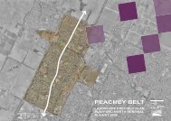
Housing <strong>SA</strong> owns a considerable number <strong>of</strong> properties/dwellings within the Peachey Belt.<br />
Based on 2001 Census data for the suburbs <strong>of</strong> Davoren Park, Smithfield and Smithfield Plains,<br />
Housing <strong>SA</strong> owns approximately 35% <strong>of</strong> the existing residential dwelling stock. Over the past<br />
decade or so the number and proportion <strong>of</strong> Housing <strong>SA</strong> owned properties has declined<br />
considerably, down from approximately 55% <strong>of</strong> the total housing stock at the 1991 Census.<br />
It is evident that there are several distinct clusters <strong>of</strong> relatively high concentrations <strong>of</strong> Housing <strong>SA</strong><br />
properties, these being:<br />
• west <strong>of</strong> Peachey Road and south <strong>of</strong> Curtis Road, Smithfield Plains, comprising mainly double<br />
units and vacant land;<br />
• west <strong>of</strong> Peachey Road, south <strong>of</strong> Davoren Road and north <strong>of</strong> Whittington Road, Davoren Park,<br />
comprising a mix <strong>of</strong> single and double units;<br />
• west <strong>of</strong> Bishopstone’s Road, south <strong>of</strong> Bulkington Road and north <strong>of</strong> Womma Road, Davoren<br />
Park, comprising predominantly double units;<br />
• east <strong>of</strong> Peachey Road, Smithfield Plains, approximately 20% <strong>of</strong> the overall housing stock,<br />
primarily in the form <strong>of</strong> single units;<br />
• south <strong>of</strong> Whittington Road, east <strong>of</strong> Ward Street, west <strong>of</strong> Coventry Road and north <strong>of</strong> Neagle<br />
Road, Davoren Park, comprising primarily double units.<br />
1.5.2 Land Use/Site History<br />
The substantial majority <strong>of</strong> existing broad hectare land located within the Area Affected is used for<br />
cropping and grazing purposes, or is otherwise vacant. It is understood that historically much <strong>of</strong> the<br />
existing broad hectare land was actively used for farming/grazing purposes until purchased by the<br />
South Australian Urban Land Trust in the 1970’s.<br />
Those areas which have been more intensively developed include:<br />
• a residential enclave located north <strong>of</strong> Craigmore Road, Blakeview, which was established within<br />
the last decade;<br />
• the established suburb <strong>of</strong> Munno Para, located immediately to the west <strong>of</strong> Main North Road.<br />
This suburb has been essentially developed for residential purposes by the then South<br />
Australian Housing Trust. The suburb was developed in a Radburn style layout for and<br />
includes:<br />
- a State Primary School, local shopping centre (owned by LMC) and largely<br />
undeveloped reserve on Karri Street which links Main North Road with the Munno Para<br />
Railway Station;<br />
- the Munno Para Bowls Club on the intersection <strong>of</strong> Main North and Curtis Roads;<br />
- State heritage listed 1890 house at 36 Maltarra Road; and<br />
- Many houses owned by Housing <strong>SA</strong> and the Defence Housing Authority.<br />
• the developing suburb <strong>of</strong> Munno Para West, where original horticultural activities have steadily<br />
been displaced by the ad-hoc division <strong>of</strong> land into residential allotments;<br />
• the well established suburbs <strong>of</strong> Smithfield Plains and Davoren Park, the majority <strong>of</strong> which was<br />
developed in the 1960’s by the then <strong>SA</strong>HT and known as the Peachey Belt. The majority <strong>of</strong> this<br />
area was developed for residential purposes, however is serviced by three Local Centres, all <strong>of</strong><br />
which contain small scale retail and/or consulting room type facilities. The Peachey Belt also<br />
includes two Primary School’s and one Secondary School, plus the Para West Adult Campus.<br />
Light industrial and commercial uses are located adjacent to Curtis Road, Smithfield and also<br />
<strong>Playford</strong> North DPA -8-<br />
Jul 08<br />
Final DPA 20 August 08.doc Version 3