Development Plan - City of Playford - SA.Gov.au
Development Plan - City of Playford - SA.Gov.au
Development Plan - City of Playford - SA.Gov.au

You also want an ePaper? Increase the reach of your titles
YUMPU automatically turns print PDFs into web optimized ePapers that Google loves.
• the need to establish several new activity centres in order to service the new population, which<br />
would provide opportunity to support smaller household types and higher residential densities;<br />
• the overall concept <strong>of</strong> creating connected communities through road layout and open space<br />
distribution, which major open space networks supporting higher density housing, such as two<br />
storey townhouses and terrace homes;<br />
• the overall concept <strong>of</strong> providing attractive streetscapes whilst maximizing the efficient use <strong>of</strong><br />
land, with rear laneway development a means <strong>of</strong> facilitating both objectives, whilst also<br />
enabling the provision <strong>of</strong> alternate housing forms such as mews dwellings.<br />
The key amendments to the <strong>Development</strong> <strong>Plan</strong> in order to facilitate the above include:<br />
• an update <strong>of</strong> existing structure plans, particularly those that apply to Blakeview, Munno Para<br />
West, Andrews Farm and Penfield;<br />
• new desired future character statements and policy which clearly outline the future design and<br />
character intent, with specific reference to urban design, land division and road layout, housing<br />
form and density;<br />
• amended/new provisions relating to building height, front, side and rear setback, site coverage<br />
and private open space provisions which are specifically tailored to higher density housing<br />
forms and new housing forms such as terrace housing and mews dwellings;<br />
• amended/new provisions relating to complying development and public notification categories.<br />
6.3 Activity Centres<br />
6.3.1 Existing Centres<br />
Metropolitan Adelaide has a designated hierarchy <strong>of</strong> Activity Centres based on function, as ranked<br />
below from highest to lowest order level <strong>of</strong> centre:<br />
• CBD;<br />
• Regional Activity Centre (eg: Elizabeth, Tea Tree Gully);<br />
• District Activity Centre (eg: Munno Para, Gawler, Salisbury Town Centre);<br />
• Neighbourhood Activity Centre (eg: Craigmore); and<br />
• Local Activity Centre (eg: Smithfield Plains, Swallowcliff).<br />
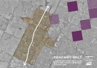
The Area Affected is served by a range <strong>of</strong> centres. At the highest level, the CBD provides for high<br />
order shopping, entertainment, cultural activities and specialist services and facilities. The CBD’s<br />
influence over the Area Affected is expected to be relatively small, given its distance from Munno<br />
Para West / Blakeview / Penfield / Peachey Belt, the typical destinations <strong>of</strong> the majority <strong>of</strong> the local<br />
workforce and the prevailing socio-demographic characteristics <strong>of</strong> the population. The CBD’s<br />
influence is unlikely to grow into the future.<br />
At the regional level, Elizabeth <strong>City</strong> Centre serves the Area Affected. It is located approximately 5<br />
km to the south <strong>of</strong> the Area Affected and is directly accessible via Main North Road and a number<br />
<strong>of</strong> collector roads, including Peachey Road and Yorktown Road. Elizabeth <strong>City</strong> Centre contains the<br />
following key retailers and services:<br />
Elizabeth <strong>City</strong> Centre contains nearly 70,000 m 2 <strong>of</strong> retail floorspace and has undergone a major<br />
refurbishment in recent times. It is well served by car parking, buses and trains. It will continue to<br />
exert influence over the Area Affected into the future, however, it has been challenged by the<br />
expansion and floorspace mix <strong>of</strong> the Munno Para District Centre in recent years, which is much<br />
more proximate to the majority <strong>of</strong> the Area Affected.<br />
Munno Para District Centre is located on Main North Road, less than 1km from the Area Affected.<br />
Access is via Main North Road, Uley Road and Warooka Drive / Konanda Road.<br />
<strong>Playford</strong> North DPA -85-<br />
Jul 08<br />
Final DPA 20 August 08.doc Version 3