Development Plan - City of Playford - SA.Gov.au
Development Plan - City of Playford - SA.Gov.au
Development Plan - City of Playford - SA.Gov.au

Create successful ePaper yourself
Turn your PDF publications into a flip-book with our unique Google optimized e-Paper software.
• better health and community facilities (including open space); and<br />
• better public transport options.<br />
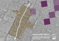
The Project’s physical description is as follows:<br />
• total area <strong>of</strong> 930 hectares;<br />
• 15 year plus project, with the development <strong>of</strong> more than 10,000 new homes;<br />
• renewal <strong>of</strong> the Peachey Belt effecting 1,177 <strong>SA</strong>HT properties;<br />
• population growth from 13,000 to approximately 40,000 people.<br />
The Project is being led by the Land Management Corporation (LMC) in partnership with the<br />
Department for Families and Communities (Housing <strong>SA</strong>) and the <strong>City</strong> <strong>of</strong> <strong>Playford</strong>. The <strong>Playford</strong><br />
North community is also acknowledged as an important partner in this Project. In addition, there<br />
will be significant contributions from other State <strong>Gov</strong>ernment agencies and working relationships<br />
established with a range <strong>of</strong> non-<strong>Gov</strong>ernment, Local and Commonwealth <strong>Gov</strong>ernment services<br />
and agencies.<br />
An extensive master planning process has occurred to date, including community consultation.<br />
The <strong>Playford</strong> Alive Master <strong>Plan</strong> is in the process <strong>of</strong> final drafting prior to stakeholder<br />
endorsement.<br />
The draft Master <strong>Plan</strong> is both comprehensive in terms <strong>of</strong> scope and detail, and provides for the<br />
implementation <strong>of</strong> the possible intended outcomes, many <strong>of</strong> which are not adequately supported<br />
by the current <strong>Development</strong> <strong>Plan</strong> provisions. Key future development outcomes as proposed in<br />
the Master <strong>Plan</strong> include:<br />
Munno Para West<br />
• a large neighbourhood centre, town park and lake/wetland to the north <strong>of</strong> Curtis Road;<br />
• accommodation <strong>of</strong> a Birth-Year 12 school to the north <strong>of</strong> the neighbourhood centre;<br />
• potential private education facility site west <strong>of</strong> Munno Para Railway Station;<br />
• playing fields adjacent to the B-12 school;<br />
• a Transit Oriented <strong>Development</strong> (TOD) around the Munno Para Railway Station which<br />
includes a small neighbourhood centre;<br />
• developing local wetlands as part <strong>of</strong> the Waterpro<strong>of</strong>ing Northern Adelaide Project with the<br />
major site near Curtis Road and Coventry Road;<br />
• creation <strong>of</strong> local employment opportunities in commercial areas fronting Curtis Road;<br />
• encouraging a range <strong>of</strong> housing development densities near the large shopping centre and<br />
Munno Para Railway Station.<br />
Andrews Farm South<br />
• a small neighbourhood shopping centre on Petherton Road;<br />
• a possible future primary school.<br />
Davoren Park<br />
• rezoning the shopping centre on the corner <strong>of</strong> Peachey Road/Whitington Road to pave the<br />
way for future expansion;<br />
• redevelopment <strong>of</strong> the Davoren Park Primary School.<br />
Smithfield Plains<br />
• a new Birth-Year 7 school in the eastern part <strong>of</strong> Kooranowa Reserve; and<br />
• redeveloping the Smithfield Plains Primary School and Smithfield Plains High School sites.