Development Plan - City of Playford - SA.Gov.au
Development Plan - City of Playford - SA.Gov.au
Development Plan - City of Playford - SA.Gov.au

You also want an ePaper? Increase the reach of your titles
YUMPU automatically turns print PDFs into web optimized ePapers that Google loves.
4. Encourage people to walk and cycle<br />
to destinations by providing suitable<br />
infrastructure and developing safe,<br />
attractive and convenient walking and<br />
cycling environments.<br />
(a) Provide a safe, strategic network <strong>of</strong><br />
commuter and recreational links<br />
between major cycle trip destinations,<br />
such as activity centres, community<br />
facilities, public transport, parks and<br />
residential neighbourhoods.<br />
(c) Develop high-quality walking<br />
environments designed for the comfort,<br />
ease and safety <strong>of</strong> all users.<br />
(d) Improve opportunities for incidental<br />
exercise (particularly walking and<br />
cycling) by locating residential<br />
neighbourhoods and key services and<br />
facilities and other regularly visited<br />
destinations within walking distance <strong>of</strong><br />
each other.<br />
9. Ensure integrated transport and land<br />
use supports quality <strong>of</strong> life outcomes.<br />
(a) Ensure that road corridors are planned<br />
to integrate land use and transport to<br />
address health and safety issues along<br />
transport routes.<br />
(b) Design and locate development adjacent<br />
transport corridors to minimise health<br />
and safety issues arising from road<br />
traffic noise and transport uses through<br />
consideration <strong>of</strong> a range <strong>of</strong> factors<br />
including distance from major transport<br />
corridors, building layout and design, the<br />
inclusion <strong>of</strong> noise attenuation measures,<br />
safe pedestrian and vehicle access<br />
points, and appropriate building<br />
ventilation.<br />
(e) Provide pedestrian and cycle corridors<br />
separate from transport routes and in<br />
coordination with the establishment <strong>of</strong><br />
facilities in MOSS, Parklands, linear<br />
parks, and other public open spaces.<br />
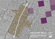
The Structure <strong>Plan</strong> incorporates major and<br />
minor road networks, together with open<br />
space networks and connections. These key<br />
features provide for the reinforcement and<br />
expansion <strong>of</strong> existing pedestrian and cycling<br />
networks and the creation <strong>of</strong> new ones.<br />
A key philosophy <strong>of</strong> the intended urban<br />
design outcome is to create walkable<br />
communities. This is to be achieved through<br />
the regular dispersal <strong>of</strong> activity centres<br />
throughout the Area Affected, policy which<br />
requires footpaths on both sides <strong>of</strong> the road,<br />
and structure plans which ensure connectivity<br />
between open space areas.<br />
Existing and predicted future traffic volumes<br />
have been considered as part <strong>of</strong> the<br />
preparation <strong>of</strong> the structure plans. For<br />
instance, the future establishment <strong>of</strong> NEXY<br />
will have a significant impact on traffic<br />
movements on Curtis Road. This has<br />
required an urban design response to the<br />
planning <strong>of</strong> future development to the north <strong>of</strong><br />
Curtis Road, relating to land use, allotment<br />
depth and access considerations.<br />
It is anticipated that all future activity centres<br />
will be well serviced by future public transport<br />
networks.<br />
<strong>Playford</strong> North DPA -45-<br />
Jul 08<br />
Final DPA 20 August 08.doc Version 3