- Page 1 and 2:
Chapter and Section Chapter 1: Meas
- Page 3 and 4:
Chapter and Section Chapter 5: Forc
- Page 5 and 6:
Chapter and Section Chapter 9: Heat
- Page 7 and 8:
Chapter and Section Chapter 14: Cha
- Page 9 and 10:
Chapter and Section Chapter 18: Ear
- Page 11 and 12:
Chapter and Section Chapter 24: Wav
- Page 13 and 14:
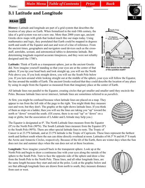
Name: Date: 1.1 Lab Safety What can
- Page 15 and 16:
Page 3 of 6 Safety quiz 1. Draw a d
- Page 17 and 18:
Page 5 of 6 c. You suddenly you beg
- Page 19 and 20:
Name: Date: 1.1 Using Your Textbook
- Page 21 and 22:
Page 2 of 3 The following prefixes
- Page 23 and 24:
Name: Date: 1.1 Scientific Notation
- Page 25 and 26:
Page 3 of 3 3. Write the numbers in
- Page 27 and 28:
Page 2 of 4 Example 1: Measuring ob
- Page 29 and 30:
Page 4 of 4 4. . Prefix Symbol Mult
- Page 31 and 32:
Name: Date: 1.2 Reading Strategies
- Page 33 and 34:
Name: Date: 1.2 Stopwatch Math What
- Page 35 and 36: Name: Date: 1.2 Understanding Light
- Page 37 and 38: Name: Date: 1.2 Indirect Measuremen
- Page 39 and 40: Name: Date: 1.3 Dimensional Analysi
- Page 41 and 42: Name: Date: Skill Builder Fractions
- Page 43 and 44: Page 3 of 4 Solving fraction proble
- Page 45 and 46: Name: Date: 1.3 Significant Digits
- Page 47 and 48: Page 3 of 4 Follow these steps for
- Page 49 and 50: Name: Date: 1.3 Study Notes This sk
- Page 51 and 52: Name: Date: 1.3 Science Vocabulary
- Page 53 and 54: Page 3 of 3 Using the table of pref
- Page 55 and 56: Page 2 of 2 5. Earth’s moon is co
- Page 57 and 58: Page 2 of 3 When precise conversion
- Page 59 and 60: Name: Date: 1.4 Creating Scatterplo
- Page 61 and 62: Page 3 of 3 g. What is the position
- Page 63 and 64: Page 2 of 2 1.4 1. Given the variab
- Page 65 and 66: Page 2 of 3 Step 3: Look at the ran
- Page 67 and 68: Name: Date: 1.4 Recognizing Pattern
- Page 69 and 70: Page 3 of 3 Answer the following qu
- Page 71 and 72: Page 2 of 2 4. Measurements: List a
- Page 73 and 74: Page 2 of 2 2. Your teacher shows y
- Page 75 and 76: Page 2 of 4 Recording valid observa
- Page 77 and 78: Page 4 of 4 b. How did the student
- Page 79 and 80: Page 2 of 3 Name: Lucy O. Date: Jan
- Page 81 and 82: Name: Date: 2.2 Using Computer Spre
- Page 83 and 84: Page 3 of 3 5. The following data i
- Page 85: Page 2 of 2 2. John notices that hi
- Page 89 and 90: Page 3 of 4 Use an atlas or globe t
- Page 91 and 92: Name: Date: 3.1 Map Scales Mapmaker
- Page 93 and 94: Page 3 of 3 f. Point Q to Point M g
- Page 95 and 96: Page 2 of 5 It’s time to go! 3.1
- Page 97 and 98: Page 4 of 5 37. Now you will head t
- Page 99 and 100: Name: Date: 4.1 Vectors on a Map Yo
- Page 101 and 102: Page 2 of 3 1. Draw a profile map o
- Page 103 and 104: Name: Date: 3.3 Bathymetric Maps Im
- Page 105 and 106: Page 1 of 2 3.3 Tanya Atwater Tanya
- Page 107 and 108: Name: Date: 4.1 Solving Equations w
- Page 109 and 110: Page 3 of 4 Use the formula V = l
- Page 111 and 112: Name: Date: 4.1 Problem Solving Box
- Page 113 and 114: Page 2 of 3 In problems 6 and 7, yo
- Page 115 and 116: Name: Date: 4.1 Percent Error When
- Page 117 and 118: Page 3 of 3 1. The lab group conduc
- Page 119 and 120: Page 2 of 3 1. A bicyclist travels
- Page 121 and 122: Name: Date: 4.1 Velocity Speed and
- Page 123 and 124: Name: Date: 4.2 Calculating Slope f
- Page 125 and 126: Name: Date: 4.2 Analyzing Graphs of
- Page 127 and 128: Page 3 of 4 1. For each position-ti
- Page 129 and 130: Name: Date: 4.2 Analyzing Graphs of
- Page 131 and 132: Name: Date: 4.3 Acceleration Accele
- Page 133 and 134: Name: Date: 4.3 Acceleration and Sp
- Page 135 and 136: Page 3 of 3 3. Graph 3: 4. Find acc
- Page 137 and 138:
Page 2 of 3 Example 1: How fast wil
- Page 139 and 140:
Name: Date: 5.1 Ratios and Proporti
- Page 141 and 142:
Name: Date: 5.1 Internet Research S
- Page 143 and 144:
Name: Date: 5.1 Preparing a Bibliog
- Page 145 and 146:
Name: Date: 5.1 Mass vs. Weight Wha
- Page 147 and 148:
Page 2 of 2 1. A physical science t
- Page 149 and 150:
Page 2 of 2 How much does it weigh
- Page 151 and 152:
Page 2 of 2 Answer the following pr
- Page 153 and 154:
Name: Date: 5.3 Equilibrium When al
- Page 155 and 156:
Name: Date: 6.1 Net Force and Newto
- Page 157 and 158:
Page 2 of 2 Reading reflection 1. I
- Page 159 and 160:
Name: Date: 6.3 Applying Newton’s
- Page 161 and 162:
Name: Date: 6.3 Momentum Conservati
- Page 163 and 164:
Name: Date: 6.3 Collisions and Cons
- Page 165 and 166:
Name: Date: 6.3 Rate of Change of M
- Page 167 and 168:
Page 3 of 3 6. A 50.-g (0.050-kg) e
- Page 169 and 170:
Page 2 of 2 1. A machine uses an in
- Page 171 and 172:
Page 2 of 2 Example 3: A 500-newton
- Page 173 and 174:
Page 2 of 2 7. You pull your sled t
- Page 175 and 176:
Page 2 of 2 The relationship betwee
- Page 177 and 178:
Page 2 of 2 6. Use the gear ratio f
- Page 179 and 180:
Page 2 of 2 The three classes of le
- Page 181 and 182:
Page 2 of 2 3. Now, calculate the g
- Page 183 and 184:
Page 2 of 2 To do this calculation,
- Page 185 and 186:
Name: Date: 7.2 Energy Transformati
- Page 187 and 188:
Name: Date: 7.2 Conservation of Ene
- Page 189 and 190:
Page 2 of 2 Reading reflection 1. W
- Page 191 and 192:
Name: Date: 7.3 Power In science, w
- Page 193 and 194:
Name: Date: 7.3 Power in Flowing En
- Page 195 and 196:
Name: Date: 7.3 Efficiency and Ener
- Page 197 and 198:
Page 2 of 2 Reading the temperature
- Page 199 and 200:
Page 2 of 4 1. For each of the prob
- Page 201 and 202:
Page 4 of 4 1. Surface temperatures
- Page 203 and 204:
Page 2 of 2 The graph below shows a
- Page 205 and 206:
Name: Date: 9.1 Using the Heat Equa
- Page 207 and 208:
Name: Date: 10.1 Measuring Mass wit
- Page 209 and 210:
Page 3 of 3 Reading the balance cor
- Page 211 and 212:
Page 2 of 2 d. Explain how the disp
- Page 213 and 214:
Page 2 of 3 Calculating volume of a
- Page 215 and 216:
Name: Date: 10.1 Density The densit
- Page 217 and 218:
Name: Date: 10.3 Pressure in Fluids
- Page 219 and 220:
Name: Date: 10.3 Boyle’s Law The
- Page 221 and 222:
Name: Date: 10.4 Charles’s Law Ch
- Page 223 and 224:
Name: Date: 10.4 Archimedes 10.4 Ar
- Page 225 and 226:
Name: Date: 10.4 Narcís Monturiol
- Page 227 and 228:
Name: Date: 10.4 Archimedes’ Prin
- Page 229 and 230:
Name: Date: 11.1 Layers of the Atmo
- Page 231 and 232:
Page 2 of 2 Reading reflection 1. H
- Page 233 and 234:
Page 2 of 3 Using temperature data
- Page 235 and 236:
Page 1 of 2 11.3 Joanne Simpson 11.
- Page 237 and 238:
Name: Date: 11.3 Weather Maps You h
- Page 239 and 240:
Name: Date: 11.3 Tracking a Hurrica
- Page 241 and 242:
Page 3 of 4 Hurricane Andrew crosse
- Page 243 and 244:
Name: Date: 12.1 Structure of the A
- Page 245 and 246:
Name: Date: 12.1 Atoms and Isotopes
- Page 247 and 248:
Name: Date: 12.1 Ernest Rutherford
- Page 249 and 250:
Name: Date: 12.2 Electrons and Ener
- Page 251 and 252:
Page 2 of 2 Reading reflection 1. H
- Page 253 and 254:
Page 2 of 2 Periodic Table Groups T
- Page 255 and 256:
Page 2 of 2 Using dot diagrams to r
- Page 257 and 258:
Page 2 of 2 13.2 Important note: If
- Page 259 and 260:
Page 2 of 2 Example 2: Aluminum and
- Page 261 and 262:
Page 2 of 2 13.2 Predict the name o
- Page 263 and 264:
Page 2 of 2 Using the information i
- Page 265 and 266:
Page 2 of 3 Conservation of atoms T
- Page 267 and 268:
Name: Date: 14.1 The Avogadro Numbe
- Page 269 and 270:
Page 3 of 4 Substance Elements in s
- Page 271 and 272:
Name: Date: 14.1 Formula Mass A che
- Page 273 and 274:
Name: Date: 14.2 Classifying Reacti
- Page 275 and 276:
Name: Date: 14.2 Predicting Chemica
- Page 277 and 278:
Name: Date: 14.2 Percent Yield You
- Page 279 and 280:
Name: Date: 14.4 Lise Meitner Lise
- Page 281 and 282:
Name: Date: 14.4 Marie and Pierre C
- Page 283 and 284:
Page 3 of 3 Reading reflection 1. W
- Page 285 and 286:
Page 2 of 2 Reading reflection 1. R
- Page 287 and 288:
Page 2 of 2 Reading reflection 1. U
- Page 289 and 290:
Page 2 of 2 1. The decay series for
- Page 291 and 292:
Page 2 of 2 Reading reflection 1. D
- Page 293 and 294:
. Page 2 of 3 i. Switches 2, 3, and
- Page 295 and 296:
Name: Date: 16.1 Benjamin Franklin
- Page 297 and 298:
Name: Date: 16.2 Using an Electric
- Page 299 and 300:
Page 3 of 4 Build a series circuit
- Page 301 and 302:
Name: Date: 16.3 Voltage, Current,
- Page 303 and 304:
Page 3 of 3 Now you will have the o
- Page 305 and 306:
Page 2 of 2 7. How much voltage wou
- Page 307 and 308:
Page 2 of 2 5. Use the series circu
- Page 309 and 310:
Page 2 of 2 In part (d) of problems
- Page 311 and 312:
Page 2 of 2 Reading reflection 1. N
- Page 313 and 314:
Page 2 of 2 Reading reflection 1. W
- Page 315 and 316:
Page 2 of 2 Reading reflection 1. H
- Page 317 and 318:
Page 2 of 2 7. The directions—nor
- Page 319 and 320:
Page 2 of 2 6. Repeat step 5 to for
- Page 321 and 322:
Page 2 of 2 Reading reflection 1. W
- Page 323 and 324:
Page 2 of 2 A transformer steps dow
- Page 325 and 326:
Page 2 of 2 4. Calculate the power
- Page 327 and 328:
Page 2 of 2 Reading reflection 1. H
- Page 329 and 330:
Page 2 of 4 Determining the relativ
- Page 331 and 332:
Page 4 of 4 Extension—Creating cl
- Page 333 and 334:
Page 2 of 2 Reading reflection 1. N
- Page 335 and 336:
Name: Date: 19.1 Earth’s Interior
- Page 337 and 338:
Page 2 of 2 Reading reflection 1. L
- Page 339 and 340:
Page 2 of 2 Reading reflection 1. W
- Page 341 and 342:
Page 2 of 2 Reading reflection 1. E
- Page 343 and 344:
Page 2 of 2 Reading reflection 1. H
- Page 345 and 346:
Page 2 of 2 Reading reflection 1. H
- Page 347 and 348:
Name: Date: 19.4 Continental United
- Page 349 and 350:
Page 3 of 4 When a mountain is form
- Page 351 and 352:
Name: Date: 20.1 Averaging The most
- Page 353 and 354:
Page 2 of 5 Locating the epicenter
- Page 355 and 356:
Page 4 of 5 20.1 For each of the pr
- Page 357 and 358:
Name: Date: 20.2 Volcano Parts 20.2
- Page 359 and 360:
Name: Date: 21.2 Calculating Concen
- Page 361 and 362:
Name: Date: 21.2 Solubility In this
- Page 363 and 364:
Page 3 of 3 The influence of temper
- Page 365 and 366:
Page 2 of 3 Work through these exam
- Page 367 and 368:
Name: Date: 21.3 Calculating pH The
- Page 369 and 370:
Name: Date: 22.1 Groundwater and We
- Page 371 and 372:
Page 3 of 3 Testing the model: 1. W
- Page 373 and 374:
Name: Date: 24.1 Period and Frequen
- Page 375 and 376:
Page 2 of 2 2. Use the grids below
- Page 377 and 378:
Page 2 of 2 2. Use the grids below
- Page 379 and 380:
Page 2 of 3 x-axis (blocks) Height
- Page 381 and 382:
Name: Date: 24.3 Decibel Scale The
- Page 383 and 384:
Page 2 of 2 a. ____________________
- Page 385 and 386:
Page 2 of 2 2. Two students want to
- Page 387 and 388:
Name: Date: 24.3 Palm Pipes Project
- Page 389 and 390:
Page 3 of 3 6. Challenge: You can f
- Page 391 and 392:
Page 2 of 2 Answer the following pr
- Page 393 and 394:
Page 2 of 2 4. You see a chair that
- Page 395 and 396:
Page 2 of 2 a. ____________________
- Page 397 and 398:
Name: Date: 25.3 Using Ray Diagrams
- Page 399 and 400:
Page 2 of 2 2. Light strikes a mirr
- Page 401 and 402:
Page 2 of 2 Which way does the ligh
- Page 403 and 404:
Page 2 of 2 25.3 1. A lens has a fo
- Page 405 and 406:
Name: Date: 26.1 Gravity Problems I
- Page 407 and 408:
Name: Date: 26.1 Universal Gravitat
- Page 409 and 410:
Page 1 of 2 26.1 Nicolaus Copernicu
- Page 411 and 412:
Page 1 of 2 26.1 Galileo Galilei Ga
- Page 413 and 414:
Page 1 of 2 26.1 Johannes Kepler 26
- Page 415 and 416:
Name: Date: 26.1 Measuring the Moon
- Page 417 and 418:
Page 3 of 3 Semi-Circle Card: 26.1
- Page 419 and 420:
Page 2 of 2 Reading reflection 1. B
- Page 421 and 422:
Page 2 of 2 Part 2: Provisions for
- Page 423 and 424:
Page 1 of 2 27.1 Arthur Walker 27.1
- Page 425 and 426:
Name: Date: 27.2 The Inverse Square
- Page 427 and 428:
Page 2 of 3 1. Fill in the missing
- Page 429 and 430:
Name: Date: 28.1 Understanding Ligh
- Page 431 and 432:
Name: Date: 28.1 Parsecs You have a
- Page 433 and 434:
Page 1 of 2 28.1 Edwin Hubble Edwin
- Page 435 and 436:
Name: Date: 28.2 Light Intensity Pr
- Page 437 and 438:
Page 2 of 2 Reading reflection 1. H
- Page 439 and 440:
Page 2 of 2 If we know the brightne
- Page 441 and 442:
Page 2 of 2 Solving Doppler Shift P
- Page 443 and 444:
13. A decimeter is 100 times larger
- Page 445 and 446:
Skill Sheet 1.3: Significant Digits
- Page 447 and 448:
7. Yes, there is a relationship bet
- Page 449 and 450:
6. The slope is the same (2.0) unti
- Page 451 and 452:
13. S Sh—Sand and shells on the b
- Page 453 and 454:
10. 410 miles 11. 6.6 miles -------
- Page 455 and 456:
Skill Sheet 4.2: Analyzing Graphs o
- Page 457 and 458:
Skill Sheet 5.1: Mass, Weight, and
- Page 459 and 460:
Skill Sheet 6.3: Applying Newton’
- Page 461 and 462:
Skill Sheet 7.1: Mechanical Advanta
- Page 463 and 464:
8. The middle gear turns left. The
- Page 465 and 466:
Skill Sheet 7.3: Power in Flowing E
- Page 467 and 468:
Skill Sheet 10.1: Calculating volum
- Page 469 and 470:
3. Answers are: a. 100 cm 3 b. 13 N
- Page 471 and 472:
Skill Sheet 11.3: Weather Maps Samp
- Page 473 and 474:
a. b. c. d. e f. Skill Sheet 12.2:
- Page 475 and 476:
Skill Sheet 14.1: Chemical Equation
- Page 477 and 478:
must be blocking their insulin’s
- Page 479 and 480:
8. The current is approximately the
- Page 481 and 482:
7. Students can find information ab
- Page 483 and 484:
Skill Sheet 17.4: Electrical Power
- Page 485 and 486:
Skill Sheet 19.1: Charles Richter 1
- Page 487 and 488:
Practice 2: 1. First problem is don
- Page 489 and 490:
Skill Sheet 21.3: Calculating pH 1.
- Page 491 and 492:
Question 8 (con’t) 9. The new wav
- Page 493 and 494:
Skill Sheet 25.2: The Human Eye a.
- Page 495 and 496:
Skill Sheet 26.1: Nicolaus Copernic
- Page 497 and 498:
Skill Sheet 27.1: Arthur Walker 1.