- Page 1:
Edward J.Tarbuck Frederick K. Lutge
- Page 5 and 6:
Ciencias de la Tierra UNA INTRODUCC
- Page 7:
En memoria de nuestros padres, nues
- Page 11 and 12:
IE N CIA S D E TIER R L A GEODe: Ci
- Page 13 and 14:
Índice de contenido IE N CIA S D E
- Page 15 and 16:
Índice de contenido XIII IE N CIA
- Page 17 and 18:
Índice de contenido XV IE N CIA S
- Page 19 and 20:
Índice de contenido XVII IE N CIA
- Page 21:
Índice de contenido XIX Capítulo
- Page 24 and 25:
XXII Prólogo se considera el papel
- Page 26 and 27:
XXIV Prólogo co que refuerza los c
- Page 28 and 29:
2 CAPÍTULO 1 Introducción a la Ge
- Page 30 and 31:
4 CAPÍTULO 1 Introducción a la Ge
- Page 32 and 33:
6 CAPÍTULO 1 Introducción a la Ge
- Page 34 and 35:
8 CAPÍTULO 1 Introducción a la Ge
- Page 36 and 37:
10 CAPÍTULO 1 Introducción a la G
- Page 38 and 39:
12 CAPÍTULO 1 Introducción a la G
- Page 40 and 41:
14 CAPÍTULO 1 Introducción a la G
- Page 42 and 43:
16 CAPÍTULO 1 Introducción a la G
- Page 44 and 45:
18 CAPÍTULO 1 Introducción a la G
- Page 46 and 47:
20 CAPÍTULO 1 Introducción a la G
- Page 48 and 49:
22 CAPÍTULO 1 Introducción a la G
- Page 50 and 51:
24 CAPÍTULO 1 Introducción a la G
- Page 52 and 53:
26 CAPÍTULO 1 Introducción a la G
- Page 54 and 55:
28 CAPÍTULO 1 Introducción a la G
- Page 56 and 57:
30 CAPÍTULO 1 Introducción a la G
- Page 59 and 60:
CAPÍTULO 2 Tectónica de placas: e
- Page 61 and 62:
P Deriva continental: una idea que
- Page 63 and 64:
Deriva continental: una idea que se
- Page 65 and 66:
Deriva continental: una idea que se
- Page 67 and 68:
Deriva continental y paleomagnetism
- Page 69 and 70:
Deriva continental y paleomagnetism
- Page 71 and 72:
Comienzo de una revolución cientí
- Page 73 and 74:
Comienzo de una revolución cientí
- Page 75 and 76:
Comienzo de una revolución cientí
- Page 77 and 78:
Tectónica de placas: el nuevo para
- Page 79 and 80:
Tectónica de placas: el nuevo para
- Page 81 and 82:
Astenosfera Bordes divergentes 55 V
- Page 83 and 84:
Bordes convergentes 57 Ascensión C
- Page 85 and 86:
Bordes convergentes 59 Arco volcán
- Page 87 and 88:
Bordes de falla transformante (bord
- Page 89 and 90:
Bordes de falla transformante (bord
- Page 91 and 92:
Comprobación del modelo de la tect
- Page 93 and 94:
Medición del movimiento de placas
- Page 95 and 96:
¿Qué impulsa los movimientos de l
- Page 97 and 98:
¿Qué impulsa los movimientos de l
- Page 99 and 100:
La importancia de la teoría de la
- Page 101:
Recursos de la web 75 está produci
- Page 104 and 105:
78 CAPÍTULO 3 Materia y minerales
- Page 106 and 107:
80 CAPÍTULO 3 Materia y minerales
- Page 108 and 109:
82 CAPÍTULO 3 Materia y minerales
- Page 110 and 111:
84 CAPÍTULO 3 Materia y minerales
- Page 112 and 113:
86 CAPÍTULO 3 Materia y minerales
- Page 114 and 115:
88 CAPÍTULO 3 Materia y minerales
- Page 116 and 117:
90 CAPÍTULO 3 Materia y minerales
- Page 118 and 119:
92 CAPÍTULO 3 Materia y minerales
- Page 120 and 121:
94 CAPÍTULO 3 Materia y minerales
- Page 122 and 123:
96 CAPÍTULO 3 Materia y minerales
- Page 124 and 125:
98 CAPÍTULO 3 Materia y minerales
- Page 126 and 127:
100 CAPÍTULO 3 Materia y minerales
- Page 128 and 129:
102 CAPÍTULO 3 Materia y minerales
- Page 130 and 131:
104 CAPÍTULO 3 Materia y minerales
- Page 132 and 133:
106 CAPÍTULO 3 Materia y minerales
- Page 134 and 135:
108 CAPÍTULO 4 Rocas ígneas Las r
- Page 136 and 137:
110 CAPÍTULO 4 Rocas ígneas magma
- Page 138 and 139:
112 CAPÍTULO 4 Rocas ígneas pezan
- Page 140 and 141:
114 CAPÍTULO 4 Rocas ígneas Confo
- Page 142 and 143:
116 CAPÍTULO 4 Rocas ígneas Recua
- Page 144 and 145:
118 CAPÍTULO 4 Rocas ígneas 2 cm
- Page 146 and 147:
120 CAPÍTULO 4 Rocas ígneas ? A V
- Page 148 and 149:
122 CAPÍTULO 4 Rocas ígneas ? A V
- Page 150 and 151:
124 CAPÍTULO 4 Rocas ígneas Figur
- Page 152 and 153:
126 CAPÍTULO 4 Rocas ígneas nar)
- Page 154 and 155:
128 CAPÍTULO 4 Rocas ígneas potá
- Page 156 and 157:
130 CAPÍTULO 4 Rocas ígneas proce
- Page 158 and 159:
132 CAPÍTULO 4 Rocas ígneas Pregu
- Page 161 and 162:
CAPÍTULO 5 Los volcanes y otra act
- Page 163 and 164:
Naturaleza de las erupciones volcá
- Page 165 and 166:
Naturaleza de las erupciones volcá
- Page 167 and 168:
Materiales expulsados durante una e
- Page 169 and 170:
Estructuras volcánicas y estilos d
- Page 171 and 172:
Estructuras volcánicas y estilos d
- Page 173 and 174:
Estructuras volcánicas y estilos d
- Page 175 and 176:
Vivir a la sombra de un cono compue
- Page 177 and 178:
Vivir a la sombra de un cono compue
- Page 179 and 180:
Otras formas volcánicas 153 ? A VE
- Page 181 and 182:
Otras formas volcánicas 155 no se
- Page 183 and 184:
Actividad ígnea intrusiva 157 Recu
- Page 185 and 186:
Actividad ígnea intrusiva 159 yore
- Page 187 and 188:
Actividad ígnea intrusiva 161 drad
- Page 189 and 190:
Actividad ígnea intrusiva 163 lóm
- Page 191 and 192:
Actividad ígnea intrusiva 165 D. V
- Page 193 and 194:
Actividad ígnea intrusiva 167 Lito
- Page 195 and 196:
¿Pueden los volcanes cambiar el cl
- Page 197 and 198:
Resumen 171 Ahora sabemos que las n
- Page 199:
Recursos de la web 173 19. Describa
- Page 202 and 203:
176 CAPÍTULO 6 Meteorización y su
- Page 204 and 205:
178 CAPÍTULO 6 Meteorización y su
- Page 206 and 207:
180 CAPÍTULO 6 Meteorización y su
- Page 208 and 209:
182 CAPÍTULO 6 Meteorización y su
- Page 210 and 211:
184 CAPÍTULO 6 Meteorización y su
- Page 212 and 213:
186 CAPÍTULO 6 Meteorización y su
- Page 214 and 215:
188 CAPÍTULO 6 Meteorización y su
- Page 216 and 217:
190 CAPÍTULO 6 Meteorización y su
- Page 218 and 219:
192 CAPÍTULO 6 Meteorización y su
- Page 220 and 221:
194 CAPÍTULO 6 Meteorización y su
- Page 222 and 223:
196 CAPÍTULO 6 Meteorización y su
- Page 224 and 225:
198 CAPÍTULO 6 Meteorización y su
- Page 227 and 228:
CAPÍTULO 7 Rocas sedimentarias ¿Q
- Page 229 and 230:
Rocas sedimentarias detríticas 203
- Page 231 and 232:
Rocas sedimentarias detríticas 205
- Page 233 and 234:
Rocas sedimentarias químicas 207 C
- Page 235 and 236:
Rocas sedimentarias químicas 209 R
- Page 237 and 238:
Rocas sedimentarias químicas 211 r
- Page 239 and 240:
Clasificación de las rocas sedimen
- Page 241 and 242:
Ambientes sedimentarios 215 5 cm Ap
- Page 243 and 244:
Ambientes sedimentarios 217 Abanico
- Page 245 and 246:
Ambientes sedimentarios 219 brio t
- Page 247 and 248:
Estructuras sedimentarias 221 grues
- Page 249 and 250:
Resumen 223 Corriente de turbidez C
- Page 251:
Recursos de la web 225 7. ¿Por qu
- Page 254 and 255:
228 CAPÍTULO 8 Metamorfismo y roca
- Page 256 and 257:
230 CAPÍTULO 8 Metamorfismo y roca
- Page 258 and 259:
232 CAPÍTULO 8 Metamorfismo y roca
- Page 260 and 261:
234 CAPÍTULO 8 Metamorfismo y roca
- Page 262 and 263:
236 CAPÍTULO 8 Metamorfismo y roca
- Page 264 and 265:
238 CAPÍTULO 8 Metamorfismo y roca
- Page 266 and 267:
240 CAPÍTULO 8 Metamorfismo y roca
- Page 268 and 269:
242 CAPÍTULO 8 Metamorfismo y roca
- Page 270 and 271:
244 CAPÍTULO 8 Metamorfismo y roca
- Page 272 and 273:
246 CAPÍTULO 8 Metamorfismo y roca
- Page 274 and 275:
248 CAPÍTULO 8 Metamorfismo y roca
- Page 276 and 277:
250 CAPÍTULO 8 Metamorfismo y roca
- Page 278 and 279:
252 CAPÍTULO 8 Metamorfismo y roca
- Page 281 and 282:
CAPÍTULO 9 El tiempo geológico La
- Page 283 and 284:
Datación relativa: principios fund
- Page 285 and 286:
Datación relativa: principios fund
- Page 287 and 288:
Correlación de las capas rocosas 2
- Page 289 and 290:
Fósiles: evidencias de vida en el
- Page 291 and 292:
Fósiles: evidencias de vida en el
- Page 293 and 294:
Datación con radiactividad 267 y s
- Page 295 and 296:
Datación con radiactividad 269 Mas
- Page 297 and 298:
Datación con radiactividad 271 ci
- Page 299 and 300:
Escala de tiempo geológico 273 El
- Page 301 and 302:
Escala de tiempo geológico 275 Era
- Page 303 and 304:
Escala de tiempo geológico 277 Tab
- Page 305 and 306:
Resumen 279 Terciario empezó despu
- Page 307 and 308:
Preguntas de repaso 281 E K A J H B
- Page 309 and 310:
CAPÍTULO 10 Deformación de la cor
- Page 311 and 312:
Deformación 285 Tipos de esfuerzo
- Page 313 and 314:
Deformación 287 ▲ Figura 10.3 Es
- Page 315 and 316:
Cartografía de las estructuras geo
- Page 317 and 318:
Pliegues 291 ángulo de buzamiento
- Page 319 and 320:
Pliegues 293 ▲ Figura 10.9 El sin
- Page 321 and 322:
Fallas 295 Estratos más antiguos E
- Page 323 and 324:
Fallas 297 Mena a lo largo de la tr
- Page 325 and 326:
Fallas 299 fallas con desplazamient
- Page 327 and 328:
Diaclasas 301 radas y rotas produci
- Page 329 and 330:
Diaclasas 303 Alaska Canadá Califo
- Page 331 and 332: Preguntas de repaso 305 sección de
- Page 333 and 334: CAPÍTULO 11 Los terremotos ¿Qué
- Page 335 and 336: ¿Qué es un terremoto? 309 ▲ Fig
- Page 337 and 338: Ruptura y propagación de un terrem
- Page 339 and 340: Sismología 313 Los terremotos que
- Page 341 and 342: Localización de un terremoto 315 E
- Page 343 and 344: Localización de un terremoto 317 P
- Page 345 and 346: Medición de las dimensiones sísmi
- Page 347 and 348: Medición de las dimensiones sísmi
- Page 349 and 350: Medición de las dimensiones sísmi
- Page 351 and 352: Destrucción causada por los terrem
- Page 353 and 354: Destrucción causada por los terrem
- Page 355 and 356: Destrucción causada por los terrem
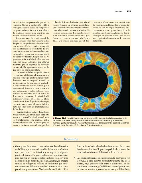
- Page 357 and 358: ¿Pueden predecirse los terremotos?
- Page 359 and 360: ¿Pueden predecirse los terremotos?
- Page 361 and 362: Terremotos: pruebas de la tectónic
- Page 363 and 364: Resumen 337 Resumen • Los terremo
- Page 365: Recursos de la web 339 inercia inte
- Page 368 and 369: 342 CAPÍTULO 12 El interior de la
- Page 370 and 371: 344 CAPÍTULO 12 El interior de la
- Page 372 and 373: 346 CAPÍTULO 12 El interior de la
- Page 374 and 375: 348 CAPÍTULO 12 El interior de la
- Page 376 and 377: 350 CAPÍTULO 12 El interior de la
- Page 378 and 379: 352 CAPÍTULO 12 El interior de la
- Page 380 and 381: 354 CAPÍTULO 12 El interior de la
- Page 384 and 385: 358 CAPÍTULO 12 El interior de la
- Page 387 and 388: CAPÍTULO 13 Bordes divergentes: or
- Page 389 and 390: Imagen del fondo oceánico 363 Señ
- Page 391 and 392: Márgenes continentales 365 Órbita
- Page 393 and 394: Márgenes continentales 367 Márgen
- Page 395 and 396: Características de las cuencas oce
- Page 397 and 398: Anatomía de una dorsal oceánica 3
- Page 399 and 400: Anatomía de una dorsal oceánica 3
- Page 401 and 402: Origen de la litosfera oceánica 37
- Page 403 and 404: Estructura de la corteza oceánica
- Page 405 and 406: Estructura de la corteza oceánica
- Page 407 and 408: Ruptura continental: el nacimiento
- Page 409 and 410: Ruptura continental: el nacimiento
- Page 411 and 412: Destrucción de la litosfera oceán
- Page 413 and 414: ▲ Apertura y cierre de cuencas oc
- Page 415 and 416: Apertura y cierre de cuencas oceán
- Page 417 and 418: Resumen 391 Resumen • La batimetr
- Page 419: Recursos de la web 393 dorsal oceá
- Page 422 and 423: 396 CAPÍTULO 14 Bordes convergente
- Page 424 and 425: 398 CAPÍTULO 14 Bordes convergente
- Page 426 and 427: 400 CAPÍTULO 14 Bordes convergente
- Page 428 and 429: 402 CAPÍTULO 14 Bordes convergente
- Page 430 and 431: 404 CAPÍTULO 14 Bordes convergente
- Page 432 and 433:
406 CAPÍTULO 14 Bordes convergente
- Page 434 and 435:
408 CAPÍTULO 14 Bordes convergente
- Page 436 and 437:
410 CAPÍTULO 14 Bordes convergente
- Page 438 and 439:
412 CAPÍTULO 14 Bordes convergente
- Page 440 and 441:
414 CAPÍTULO 14 Bordes convergente
- Page 442 and 443:
416 CAPÍTULO 14 Bordes convergente
- Page 444 and 445:
418 CAPÍTULO 14 Bordes convergente
- Page 446 and 447:
420 CAPÍTULO 14 Bordes convergente
- Page 448 and 449:
422 CAPÍTULO 14 Bordes convergente
- Page 451 and 452:
CAPÍTULO 15 Procesos gravitacional
- Page 453 and 454:
Controles y desencadenantes de los
- Page 455 and 456:
Controles y desencadenantes de los
- Page 457 and 458:
Clasificación de los procesos grav
- Page 459 and 460:
Clasificación de los procesos grav
- Page 461 and 462:
Deslizamiento de rocas 435 Figura 1
- Page 463 and 464:
Flujo de derrubios 437 Recuadro 15.
- Page 465 and 466:
Movimientos lentos 439 Flujos de ti
- Page 467 and 468:
Movimientos lentos 441 Recuadro 15.
- Page 469 and 470:
Preguntas de repaso 443 Resumen •
- Page 471 and 472:
CAPÍTULO 16 Corrientes de aguas su
- Page 473 and 474:
La Tierra como sistema: el ciclo hi
- Page 475 and 476:
Flujo de corriente 449 agua, de man
- Page 477 and 478:
Cambios de corriente arriba a corri
- Page 479 and 480:
Nivel de base y corrientes en equil
- Page 481 and 482:
Transporte del sedimento por las co
- Page 483 and 484:
Depósitos de sedimentos por las co
- Page 485 and 486:
Depósitos de sedimentos por las co
- Page 487 and 488:
Depósitos de sedimentos por las co
- Page 489 and 490:
Valles fluviales 463 debajo del niv
- Page 491 and 492:
Valles fluviales 465 Valle estrecho
- Page 493 and 494:
Meandros encajados y terrazas fluvi
- Page 495 and 496:
Río Missouri Redes de drenaje 469
- Page 497 and 498:
Inundaciones y control de la inunda
- Page 499 and 500:
Inundaciones y control de la inunda
- Page 501 and 502:
Resumen 475 de energía hidroeléct
- Page 503 and 504:
Términos fundamentales 477 5. Supo
- Page 505 and 506:
CAPÍTULO 17 Aguas subterráneas Im
- Page 507 and 508:
El nivel freático 481 que la tasa
- Page 509 and 510:
El nivel freático 483 A. 138,47 13
- Page 511 and 512:
Factores que influyen en el almacen
- Page 513 and 514:
Manantiales o fuentes 487 agua en l
- Page 515 and 516:
Fuentes termales y géiseres 489 Fi
- Page 517 and 518:
Pozos artesianos 491 Pozo Pozo Pozo
- Page 519 and 520:
Problemas relacionados con la extra
- Page 521 and 522:
Problemas relacionados con la extra
- Page 523 and 524:
Contaminación del agua subterráne
- Page 525 and 526:
El trabajo geológico del agua subt
- Page 527 and 528:
El trabajo geológico del agua subt
- Page 529 and 530:
Preguntas de repaso 503 contaminaci
- Page 531 and 532:
CAPÍTULO 18 Glaciares y glaciacion
- Page 533 and 534:
Tipos de glaciares 507 Groenlandia
- Page 535 and 536:
Tipos de glaciares 509 ▲ Figura 1
- Page 537 and 538:
Movimientos de un glaciar 511 compo
- Page 539 and 540:
Movimientos de un glaciar 513 nieve
- Page 541 and 542:
Formas creadas por la erosión glac
- Page 543 and 544:
Depósitos glaciares 517 En la cabe
- Page 545 and 546:
Formas constituidas por tills 519 r
- Page 547 and 548:
Formas constituidas por tills 521 M
- Page 549 and 550:
Formas constituidas por tills 523 U
- Page 551 and 552:
La teoría glaciar y el período gl
- Page 553 and 554:
Algunos efectos indirectos de los g
- Page 555 and 556:
Algunos efectos indirectos de los g
- Page 557 and 558:
Causas de las glaciaciones 531 Recu
- Page 559 and 560:
Causas de las glaciaciones 533 Órb
- Page 561 and 562:
Términos fundamentales 535 Pregunt
- Page 563 and 564:
CAPÍTULO 19 Desiertos y vientos Di
- Page 565 and 566:
Distribución y causas de las regio
- Page 567 and 568:
Distribución y causas de las regio
- Page 569 and 570:
Procesos geológicos en climas ári
- Page 571 and 572:
«Basin and Range»: la evolución
- Page 573 and 574:
Transporte de sedimentos por el vie
- Page 575 and 576:
Erosión eólica 549 ▲ Figura 19.
- Page 577 and 578:
Erosión eólica 551 algunas zonas
- Page 579 and 580:
Depósitos eólicos 553 A. Viento V
- Page 581 and 582:
Depósitos eólicos 555 Barjanes La
- Page 583 and 584:
Preguntas de repaso 557 depresiones
- Page 585 and 586:
CAPÍTULO 20 Líneas de costa La l
- Page 587 and 588:
La zona costera 561 A. ▲ Figura 2
- Page 589 and 590:
Olas 563 Movimiento de la ola Crest
- Page 591 and 592:
Movimiento de la arena de la playa
- Page 593 and 594:
Movimiento de la arena de la playa
- Page 595 and 596:
Movimiento de la arena de la playa
- Page 597 and 598:
Características de la línea de co
- Page 599 and 600:
Estabilización de la costa 573 est
- Page 601 and 602:
Estabilización de la costa 575 Aca
- Page 603 and 604:
Estabilización de la costa 577 A.
- Page 605 and 606:
Clasificación de las costas 579 co
- Page 607 and 608:
Clasificación de las costas 581 Mu
- Page 609 and 610:
Mareas 583 Causas de las mareas Ple
- Page 611 and 612:
Mareas 585 Altura (m) 1,0 0,5 0 -0,
- Page 613 and 614:
Preguntas de repaso 587 caracteriza
- Page 615 and 616:
CAPÍTULO 21 Energía y recursos mi
- Page 617 and 618:
Recursos energéticos 591 Recursos
- Page 619 and 620:
Carbón 593 El carbón ha sido un c
- Page 621 and 622:
Petróleo y gas natural 595 Pozo Po
- Page 623 and 624:
Algunos efectos ambientales de la c
- Page 625 and 626:
Algunos efectos ambientales de la c
- Page 627 and 628:
Arenas asfálticas y lutitas bitumi
- Page 629 and 630:
Fuentes de energía alternativas 60
- Page 631 and 632:
Fuentes de energía alternativas 60
- Page 633 and 634:
Fuentes de energía alternativas 60
- Page 635 and 636:
Recursos minerales 609 A. Bahía en
- Page 637 and 638:
Recursos minerales y procesos ígne
- Page 639 and 640:
Recursos minerales y procesos metam
- Page 641 and 642:
Depósitos de placeres 615 los elem
- Page 643 and 644:
Recursos minerales no metálicos 61
- Page 645 and 646:
Resumen 619 con las rocas sedimenta
- Page 647:
Recursos de la web 621 Términos fu
- Page 650 and 651:
624 CAPÍTULO 22 Geología planetar
- Page 652 and 653:
626 CAPÍTULO 22 Geología planetar
- Page 654 and 655:
628 CAPÍTULO 22 Geología planetar
- Page 656 and 657:
630 CAPÍTULO 22 Geología planetar
- Page 658 and 659:
632 CAPÍTULO 22 Geología planetar
- Page 660 and 661:
634 CAPÍTULO 22 Geología planetar
- Page 662 and 663:
636 CAPÍTULO 22 Geología planetar
- Page 664 and 665:
638 CAPÍTULO 22 Geología planetar
- Page 666 and 667:
640 CAPÍTULO 22 Geología planetar
- Page 668 and 669:
642 CAPÍTULO 22 Geología planetar
- Page 670 and 671:
644 CAPÍTULO 22 Geología planetar
- Page 672 and 673:
646 CAPÍTULO 22 Geología planetar
- Page 674 and 675:
648 CAPÍTULO 22 Geología planetar
- Page 676 and 677:
650 CAPÍTULO 22 Geología planetar
- Page 679:
APÉNDICE A Comparación entre unid
- Page 682 and 683:
656 GLOSARIO designar la actividad
- Page 684 and 685:
658 GLOSARIO Chimenea litoral (sea
- Page 686 and 687:
660 GLOSARIO Cratón (craton) Parte
- Page 688 and 689:
662 GLOSARIO Dolina (sinkhole) Depr
- Page 690 and 691:
664 GLOSARIO Espolones truncados (t
- Page 692 and 693:
666 GLOSARIO Geología histórica (
- Page 694 and 695:
668 GLOSARIO Llanura de inundación
- Page 696 and 697:
670 GLOSARIO juntan las morrenas la
- Page 698 and 699:
672 GLOSARIO del borde continental
- Page 700 and 701:
674 GLOSARIO Sedimento terrígeno (
- Page 702 and 703:
676 GLOSARIO ha experimentado un gr
- Page 704 and 705:
678 ÍNDICE ANALÍTICO Bauxita, 615
- Page 706 and 707:
680 ÍNDICE ANALÍTICO Dorsales, 29
- Page 708 and 709:
682 ÍNDICE ANALÍTICO Lajeamiento,
- Page 710 and 711:
684 ÍNDICE ANALÍTICO Precámbrico
- Page 712:
686 ÍNDICE ANALÍTICO Zona de frac