
You also want an ePaper? Increase the reach of your titles
YUMPU automatically turns print PDFs into web optimized ePapers that Google loves.
Problemas re<strong>la</strong>cionados con <strong>la</strong> extracción <strong>de</strong>l agua subterránea 495<br />
Recuadro 17.2<br />
▲<br />
El hombre y el medio ambiente<br />
El acuífero <strong>de</strong> Ogal<strong>la</strong><strong>la</strong>: ¿cuánto va a durar el agua?<br />
NM<br />
M O U N T A I N S<br />
Mexico<br />
R O C K Y<br />
WY<br />
CO<br />
O g a l<br />
a F o r m a<br />
l a l<br />
TX<br />
SD<br />
OK<br />
NE<br />
MN<br />
KS<br />
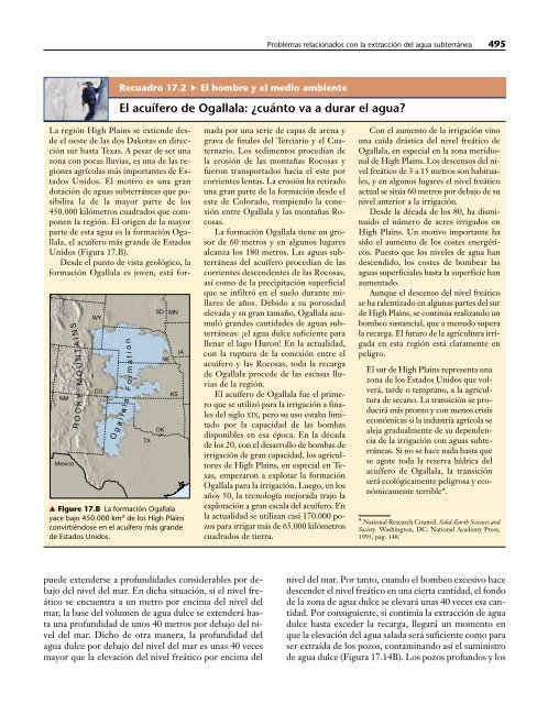
▲ Figure 17.B La formación Ogal<strong>la</strong><strong>la</strong><br />
yace bajo 450.000 km 2 <strong>de</strong> los High P<strong>la</strong>ins<br />
convirtiéndose en el acuífero más gran<strong>de</strong><br />
<strong>de</strong> Estados Unidos.<br />
t i o n<br />
IA<br />
La región High P<strong>la</strong>ins se extien<strong>de</strong> <strong>de</strong>s<strong>de</strong><br />
el oeste <strong>de</strong> <strong>la</strong>s dos Dakotas en dirección<br />
sur hasta Texas. A pesar <strong>de</strong> ser una<br />
zona con pocas lluvias, es una <strong>de</strong> <strong>la</strong>s regiones<br />
agríco<strong>la</strong>s más importantes <strong>de</strong> Estados<br />
Unidos. El motivo es una gran<br />
dotación <strong>de</strong> aguas subterráneas que posibilita<br />
<strong>la</strong> <strong>de</strong> <strong>la</strong> mayor parte <strong>de</strong> los<br />
450.000 kilómetros cuadrados que componen<br />
<strong>la</strong> región. El origen <strong>de</strong> <strong>la</strong> mayor<br />
parte <strong>de</strong> esta agua es <strong>la</strong> formación Ogal<strong>la</strong><strong>la</strong>,<br />
el acuífero más gran<strong>de</strong> <strong>de</strong> Estados<br />
Unidos (Figura 17.B).<br />
Des<strong>de</strong> el punto <strong>de</strong> vista geológico, <strong>la</strong><br />
formación Ogal<strong>la</strong><strong>la</strong> es joven, está formada<br />
por una serie <strong>de</strong> capas <strong>de</strong> arena y<br />
grava <strong>de</strong> finales <strong>de</strong>l Terciario y el Cuaternario.<br />
Los sedimentos procedían <strong>de</strong><br />
<strong>la</strong> erosión <strong>de</strong> <strong>la</strong>s montañas Rocosas y<br />
fueron transportados hacia el este por<br />
corrientes lentas. La erosión ha retirado<br />
una gran parte <strong>de</strong> <strong>la</strong> formación <strong>de</strong>s<strong>de</strong> el<br />
este <strong>de</strong> Colorado, rompiendo <strong>la</strong> conexión<br />
entre Ogal<strong>la</strong><strong>la</strong> y <strong>la</strong>s montañas Rocosas.<br />
La formación Ogal<strong>la</strong><strong>la</strong> tiene un grosor<br />
<strong>de</strong> 60 metros y en algunos lugares<br />
alcanza los 180 metros. Las aguas subterráneas<br />
<strong>de</strong>l acuífero procedían <strong>de</strong> <strong>la</strong>s<br />
corrientes <strong>de</strong>scen<strong>de</strong>ntes <strong>de</strong> <strong>la</strong>s Rocosas,<br />
así como <strong>de</strong> <strong>la</strong> precipitación superficial<br />
que se infiltró en el suelo durante mil<strong>la</strong>res<br />
<strong>de</strong> años. Debido a su porosidad<br />
elevada y su gran tamaño, Ogal<strong>la</strong><strong>la</strong> acumuló<br />
gran<strong>de</strong>s cantida<strong>de</strong>s <strong>de</strong> aguas subterráneas:<br />
¡el agua dulce suficiente para<br />
llenar el <strong>la</strong>go Huron! En <strong>la</strong> actualidad,<br />
con <strong>la</strong> ruptura <strong>de</strong> <strong>la</strong> conexión entre el<br />
acuífero y <strong>la</strong>s Rocosas, toda <strong>la</strong> recarga<br />
<strong>de</strong> Ogal<strong>la</strong><strong>la</strong> proce<strong>de</strong> <strong>de</strong> <strong>la</strong>s escasas lluvias<br />
<strong>de</strong> <strong>la</strong> región.<br />
El acuífero <strong>de</strong> Ogal<strong>la</strong><strong>la</strong> fue el primero<br />
que se utilizó para <strong>la</strong> irrigación a finales<br />
<strong>de</strong>l siglo XIX, pero su uso estaba limitado<br />
por <strong>la</strong> capacidad <strong>de</strong> <strong>la</strong>s bombas<br />
disponibles en esa época. En <strong>la</strong> década<br />
<strong>de</strong> los 20, con el <strong>de</strong>sarrollo <strong>de</strong> bombas <strong>de</strong><br />
irrigación <strong>de</strong> gran capacidad, los agricultores<br />
<strong>de</strong> High P<strong>la</strong>ins, en especial en Texas,<br />
empezaron a explotar <strong>la</strong> formación<br />
Ogal<strong>la</strong><strong>la</strong> para <strong>la</strong> irrigación. Luego, en los<br />
años 50, <strong>la</strong> tecnología mejorada trajo <strong>la</strong><br />
explotación a gran esca<strong>la</strong> <strong>de</strong>l acuífero. En<br />
<strong>la</strong> actualidad se utilizan casi 170.000 pozos<br />
para irrigar más <strong>de</strong> 65.000 kilómetros<br />
cuadrados <strong>de</strong> tierra.<br />
Con el aumento <strong>de</strong> <strong>la</strong> irrigación vino<br />
una caída drástica <strong>de</strong>l nivel freático <strong>de</strong><br />
Ogal<strong>la</strong><strong>la</strong>, en especial en <strong>la</strong> zona meridional<br />
<strong>de</strong> High P<strong>la</strong>ins. Los <strong>de</strong>scensos <strong>de</strong>l nivel<br />
freático <strong>de</strong> 3 a 15 metros son habituales,<br />
y en algunos lugares el nivel freático<br />
actual se sitúa 60 metros por <strong>de</strong>bajo <strong>de</strong> su<br />
nivel anterior a <strong>la</strong> irrigación.<br />
Des<strong>de</strong> <strong>la</strong> década <strong>de</strong> los 80, ha disminuido<br />
el número <strong>de</strong> acres irrigados en<br />
High P<strong>la</strong>ins. Un motivo importante ha<br />
sido el aumento <strong>de</strong> los costes energéticos.<br />
Puesto que los niveles <strong>de</strong> agua han<br />
<strong>de</strong>scendido, los costes <strong>de</strong> bombear <strong>la</strong>s<br />
aguas superficiales hasta <strong>la</strong> superficie han<br />
aumentado.<br />
Aunque el <strong>de</strong>scenso <strong>de</strong>l nivel freático<br />
se ha ralentizado en algunas partes <strong>de</strong>l sur<br />
<strong>de</strong> High P<strong>la</strong>ins, se continúa realizando un<br />
bombeo sustancial, que a menudo supera<br />
<strong>la</strong> recarga. El futuro <strong>de</strong> <strong>la</strong> agricultura irrigada<br />
en esta región está c<strong>la</strong>ramente en<br />
peligro.<br />
El sur <strong>de</strong> High P<strong>la</strong>ins representa una<br />
zona <strong>de</strong> los Estados Unidos que volverá,<br />
tar<strong>de</strong> o temprano, a <strong>la</strong> agricultura<br />
<strong>de</strong> secano. La transición se producirá<br />
más pronto y con menos crisis<br />
económicas si <strong>la</strong> industria agríco<strong>la</strong> se<br />
aleja gradualmente <strong>de</strong> su <strong>de</strong>pen<strong>de</strong>ncia<br />
<strong>de</strong> <strong>la</strong> irrigación con aguas subterráneas.<br />
Si no se hace nada hasta que<br />
se agote toda <strong>la</strong> reserva hídrica <strong>de</strong>l<br />
acuífero <strong>de</strong> Ogal<strong>la</strong><strong>la</strong>, <strong>la</strong> transición<br />
será ecológicamente peligrosa y económicamente<br />
terrible*.<br />
* National Research Council. Solid-Earth Sciences and<br />
Society. Washington, DC: National Aca<strong>de</strong>my Press,<br />
1993, pág. 148.<br />
pue<strong>de</strong> exten<strong>de</strong>rse a profundida<strong>de</strong>s consi<strong>de</strong>rables por <strong>de</strong>bajo<br />
<strong>de</strong>l nivel <strong>de</strong>l mar. En dicha situación, si el nivel freático<br />
se encuentra a un metro por encima <strong>de</strong>l nivel <strong>de</strong>l<br />
mar, <strong>la</strong> base <strong>de</strong>l volumen <strong>de</strong> agua dulce se exten<strong>de</strong>rá hasta<br />
una profundidad <strong>de</strong> unos 40 metros por <strong>de</strong>bajo <strong>de</strong>l nivel<br />
<strong>de</strong>l mar. Dicho <strong>de</strong> otra manera, <strong>la</strong> profundidad <strong>de</strong>l<br />
agua dulce por <strong>de</strong>bajo <strong>de</strong>l nivel <strong>de</strong>l mar es unas 40 veces<br />
mayor que <strong>la</strong> elevación <strong>de</strong>l nivel freático por encima <strong>de</strong>l<br />
nivel <strong>de</strong>l mar. Por tanto, cuando el bombeo excesivo hace<br />
<strong>de</strong>scen<strong>de</strong>r el nivel freático en una cierta cantidad, el fondo<br />
<strong>de</strong> <strong>la</strong> zona <strong>de</strong> agua dulce se elevará unas 40 veces esa cantidad.<br />
Por consiguiente, si continúa <strong>la</strong> extracción <strong>de</strong> agua<br />
dulce hasta exce<strong>de</strong>r <strong>la</strong> recarga, llegará un momento en<br />
que <strong>la</strong> elevación <strong>de</strong>l agua sa<strong>la</strong>da será suficiente como para<br />
ser extraída <strong>de</strong> los pozos, contaminando así el suministro<br />
<strong>de</strong> agua dulce (Figura 17.14B). Los pozos profundos y los