Dismounted Reconnaissance Troop - Army Electronic Publications ...
Dismounted Reconnaissance Troop - Army Electronic Publications ...
Dismounted Reconnaissance Troop - Army Electronic Publications ...

Create successful ePaper yourself
Turn your PDF publications into a flip-book with our unique Google optimized e-Paper software.
Chapter 3<br />
ORGANIZATION OF FORCES<br />
3-68. If augmented with vehicles for each platoon, the DRT can conduct reconnaissance of two vehicle<br />
routes. The integration of ground, air, and other assets can facilitate a faster and more detailed route<br />
reconnaissance.<br />
GRAPHIC CONTROL MEASURES<br />
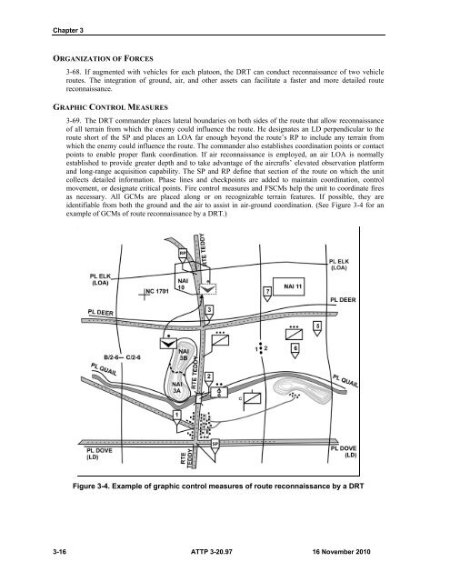
3-69. The DRT commander places lateral boundaries on both sides of the route that allow reconnaissance<br />
of all terrain from which the enemy could influence the route. He designates an LD perpendicular to the<br />
route short of the SP and places an LOA far enough beyond the route’s RP to include any terrain from<br />
which the enemy could influence the route. The commander also establishes coordination points or contact<br />
points to enable proper flank coordination. If air reconnaissance is employed, an air LOA is normally<br />
established to provide greater depth and to take advantage of the aircrafts’ elevated observation platform<br />
and long-range acquisition capability. The SP and RP define that section of the route on which the unit<br />
collects detailed information. Phase lines and checkpoints are added to maintain coordination, control<br />
movement, or designate critical points. Fire control measures and FSCMs help the unit to coordinate fires<br />
as necessary. All GCMs are placed along or on recognizable terrain features. If possible, they are<br />
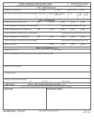
identifiable from both the ground and the air to assist in air-ground coordination. (See Figure 3-4 for an<br />
example of GCMs of route reconnaissance by a DRT.)<br />
Figure 3-4. Example of graphic control measures of route reconnaissance by a DRT<br />
3-16 ATTP 3-20.97 16 November 2010