

Soil Survey of Murray and Whitfield Counties, Georgia
Soil Survey of Murray and Whitfield Counties, Georgia
Soil Survey of Murray and Whitfield Counties, Georgia

Create successful ePaper yourself
Turn your PDF publications into a flip-book with our unique Google optimized e-Paper software.
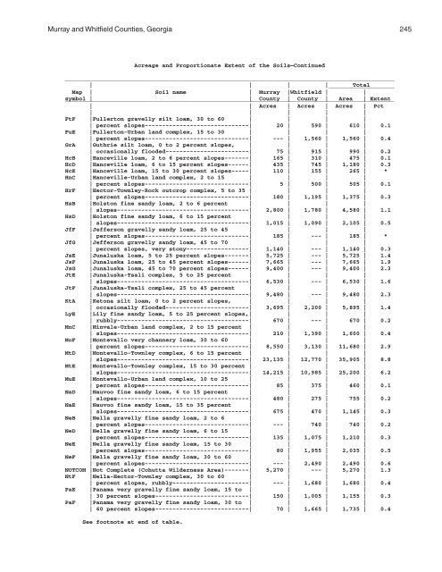
<strong>Murray</strong> <strong>and</strong> <strong>Whitfield</strong> <strong>Counties</strong>, <strong>Georgia</strong> 245<br />
Acreage <strong>and</strong> Proportionate Extent <strong>of</strong> the <strong>Soil</strong>s—Continued<br />
_______________________________________________________________________________________________<br />
| | | | ___________________<br />
Total<br />
Map | <strong>Soil</strong> name | <strong>Murray</strong> |<strong>Whitfield</strong> | |<br />
symbol _______________________________________________________________________________________________<br />
| | County | County | Area | Extent<br />
| | Acres | Acres | Acres | Pct<br />
| | | | |<br />
FtF |Fullerton gravelly silt loam, 30 to 60 | | | |<br />
| percent slopes------------------------------| 20 | 590 | 610 | 0.1<br />
FuE |Fullerton-Urban l<strong>and</strong> complex, 15 to 30 | | | |<br />
| percent slopes------------------------------| --- | 1,560 | 1,560 | 0.4<br />
GrA |Guthrie silt loam, 0 to 2 percent slopes, | | | |<br />
| occasionally flooded------------------------| 75 | 915 | 990 | 0.2<br />
HcB |Hanceville loam, 2 to 6 percent slopes-------| 165 | 310 | 475 | 0.1<br />
HcD |Hanceville loam, 6 to 15 percent slopes------| 435 | 745 | 1,180 | 0.3<br />
HcE |Hanceville loam, 15 to 30 percent slopes-----| 110 | 155 | 265 | *<br />
HnC |Hanceville-Urban l<strong>and</strong> complex, 2 to 15 | | | |<br />
| percent slopes------------------------------| 5 | 500 | 505 | 0.1<br />
HrF |Hector-Townley-Rock outcrop complex, 5 to 35 | | | |<br />
| percent slopes------------------------------| 180 | 1,195 | 1,375 | 0.3<br />
HsB |Holston fine s<strong>and</strong>y loam, 2 to 6 percent | | | |<br />
| slopes--------------------------------------| 2,800 | 1,780 | 4,580 | 1.1<br />
HsD |Holston fine s<strong>and</strong>y loam, 6 to 15 percent | | | |<br />
| slopes--------------------------------------| 1,015 | 1,090 | 2,105 | 0.5<br />
JfF |Jefferson gravelly s<strong>and</strong>y loam, 25 to 45 | | | |<br />
| percent slopes------------------------------| 185 | --- | 185 | *<br />
JfG |Jefferson gravelly s<strong>and</strong>y loam, 45 to 70 | | | |<br />
| percent slopes, very stony------------------| 1,140 | --- | 1,140 | 0.3<br />
JsE |Junaluska loam, 5 to 25 percent slopes-------| 5,725 | --- | 5,725 | 1.4<br />
JsF |Junaluska loam, 25 to 45 percent slopes------| 7,665 | --- | 7,665 | 1.9<br />
JsG |Junaluska loam, 45 to 70 percent slopes------| 9,400 | --- | 9,400 | 2.3<br />
JtE |Junaluska-Tsali complex, 5 to 25 percent | | | |<br />
| slopes--------------------------------------| 6,530 | --- | 6,530 | 1.6<br />
JtF |Junaluska-Tsali complex, 25 to 45 percent | | | |<br />
| slopes--------------------------------------| 9,480 | --- | 9,480 | 2.3<br />
KtA |Ketona silt loam, 0 to 2 percent slopes, | | | |<br />
| occasionally flooded------------------------| 3,695 | 2,200 | 5,895 | 1.4<br />
LyE |Lily fine s<strong>and</strong>y loam, 5 to 25 percent slopes,| | | |<br />
| rubbly--------------------------------------| 670 | --- | 670 | 0.2<br />
MnC |Minvale-Urban l<strong>and</strong> complex, 2 to 15 percent | | | |<br />
| slopes--------------------------------------| 210 | 1,390 | 1,600 | 0.4<br />
MoF |Montevallo very channery loam, 30 to 60 | | | |<br />
| percent slopes------------------------------| 8,550 | 3,130 | 11,680 | 2.9<br />
MtD |Montevallo-Townley complex, 6 to 15 percent | | | |<br />
| slopes--------------------------------------| 23,135 | 12,770 | 35,905 | 8.8<br />
MtE |Montevallo-Townley complex, 15 to 30 percent | | | |<br />
| slopes--------------------------------------| 14,215 | 10,985 | 25,200 | 6.2<br />
MuE |Montevallo-Urban l<strong>and</strong> complex, 10 to 25 | | | |<br />
| percent slopes------------------------------| 85 | 375 | 460 | 0.1<br />
NaD |Nauvoo fine s<strong>and</strong>y loam, 6 to 15 percent | | | |<br />
| slopes--------------------------------------| 480 | 275 | 755 | 0.2<br />
NaE |Nauvoo fine s<strong>and</strong>y loam, 15 to 35 percent | | | |<br />
| slopes--------------------------------------| 675 | 470 | 1,145 | 0.3<br />
NeB |Nella gravelly fine s<strong>and</strong>y loam, 2 to 6 | | | |<br />
| percent slopes------------------------------| --- | 740 | 740 | 0.2<br />
NeD |Nella gravelly fine s<strong>and</strong>y loam, 6 to 15 | | | |<br />
| percent slopes------------------------------| 135 | 1,075 | 1,210 | 0.3<br />
NeE |Nella gravelly fine s<strong>and</strong>y loam, 15 to 30 | | | |<br />
| percent slopes------------------------------| 80 | 1,955 | 2,035 | 0.5<br />
NeF |Nella gravelly fine s<strong>and</strong>y loam, 30 to 60 | | | |<br />
| percent slopes------------------------------| --- | 2,490 | 2,490 | 0.6<br />
NOTCOM |Not Complete (Cohutta Wilderness Area)-------| 5,270 | --- | 5,270 | 1.3<br />
NtF |Nella-Hector-Townley complex, 30 to 60 | | | |<br />
| percent slopes, rubbly----------------------| --- | 1,680 | 1,680 | 0.4<br />
PaE |Panama very gravelly fine s<strong>and</strong>y loam, 15 to | | | |<br />
| 30 percent slopes---------------------------| 150 | 1,005 | 1,155 | 0.3<br />
PaF |Panama very gravelly fine s<strong>and</strong>y loam, 30 to | | | |<br />
| 60 percent slopes---------------------------| 70 | 1,665 | 1,735 | 0.4<br />
See footnote at end <strong>of</strong> table.


