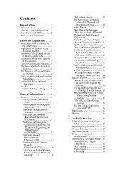
Undergraduate Catalogue - UPRM
Undergraduate Catalogue - UPRM
Undergraduate Catalogue - UPRM

You also want an ePaper? Increase the reach of your titles
YUMPU automatically turns print PDFs into web optimized ePapers that Google loves.
COLLEGE OF ENGINEERING<br />
INCI 4062. LEGAL ASPECTS II. Three credit<br />
hours. Three hours of lecture per week. Corequisite:<br />
INCI 4002.<br />
A study of those laws of Puerto Rico which rule<br />
land ownership, land transfer, and land use.<br />
INCI 4071. ADJUSTMENT COMPUTATION I.<br />
Three credit hours. Three hours of lecture per<br />
week. Prerequisites: INCI 4051 and (MATE 3063<br />
or MATE 3185).<br />
Theory and analysis of random errors, normal<br />
distribution, adjustment of simple triangulation and<br />
leveling networks by condition and observation<br />
equations, least squares.<br />
INCI 4072. ADJUSTMENT COMPUTATION II.<br />
Three credit hours. One lecture and two two-hour<br />
periods of computation per week. Prerequisite:<br />
INCI 4071.<br />
Solution of normal equations; Cholesky's method;<br />
adjustment of leveling and triangulation networks;<br />
method of variation of coordinates; Lagrangian<br />
multipliers; trisection and intersection adjustment.<br />
INCI 4078. TOPOGRAPHIC DRAWING. Two<br />
credit hours. One hour of lecture and three-hour<br />
laboratory or computation per week. Prerequisite:<br />
INCI 4002.<br />
The plane table, drawing, interpretation and<br />
utilization of topographic maps; volume<br />
computation.<br />
INCI 4079. PHOTO INTERPRETATION. Three<br />
credit hours. One lecture and two two-hour periods<br />
of computation or laboratory per week.<br />
Prerequisite: GEOL 4015 .<br />
Analysis and interpretation of patterns in aerial<br />
photography: color tones and vegetation, geologic<br />
formation, erosion, soil and rock types, drainage,<br />
and other engineering works.<br />
INCI 4081. PHOTOGRAMMETRY I. Three<br />
credit hours. Three hours of lecture per week.<br />
Prerequisites: INCI 4002 and INCI 4135.<br />
Geometry of aerial photographs, determination of<br />
distances and coordinates, elevations by radial<br />
displacement, stereoscopy, and parallax.<br />
INCI 4082. PHOTOGRAMMETRY II. Three<br />
credit hours. One hour of lecture and two two-hour<br />
periods of computation or laboratory per week.<br />
Prerequisite: INCI 4081.<br />
Flight planning and photographic control; theory of<br />
stereo plotters of the second and third order;<br />
introduction to analytical photogrammetry.<br />
INCI 4085. THEORY OF MAP PROJECTIONS.<br />
Three credit hours. Three hours of lecture per<br />
week. Prerequisites: INCI 4051 and (MATE 3063<br />
or MATE 3185).<br />
Mathematical analysis of map projections, the<br />
Lambert conformal conic projection of Puerto Rico.<br />
INCI 4086. INTRODUCTION TO PHYSICAL<br />
GEODESY. Three credit hours. Three hours of<br />
lecture per week. Prerequisite: INCI 4071.<br />
The shape of the earth, the geoid, gravimetry,<br />
Stokes' theorem applied to the determination of the<br />
shape of the earth, isostatic equilibrium.<br />
INCI 4087. SPECIAL SURVEYS. Three credit<br />
hours. Three hours of lecture per week.<br />
Prerequisite: INCI 4002.<br />
Techniques and equipment used in topographic<br />
surveys, hydrography, mine surveys, optical<br />
tooling, electronic distance measurements.<br />
INCI 4088. CARTOGRAPHY. Three credit<br />
hours. Three hours of lecture per week.<br />
History of maps; scales and projections, symbols;<br />
map reproduction, map types and their uses.<br />
INCI 4095. MATHEMATICAL METHODS IN<br />
CIVIL ENGINEERING. Two credit hours. Two<br />
hours of lecture per week. Prerequisite: INGE<br />
3016 and (MATE 3063 or MATE 3185).<br />
Numerical methods applied to Civil Engineering<br />
with computer use.<br />
INCI 4125. INTRODUCTION TO LAND<br />
INFORMATION SYSTEMS. Three credit hours.<br />
Two hours of lecture and one two-hour laboratory<br />
per week. Prerequisite: INCI 4002 and be a senior<br />
student.<br />
Methods for the acquisition and conversion of data<br />
to be used in a Land Information System (LIS) for<br />
later analysis. Different types of date structures,<br />
including databases in a LIS. Emphasis in vectorbased<br />
systems. Observe the benefits of a land<br />
information system in Puerto Rico.<br />
286 <strong>Undergraduate</strong> <strong>Catalogue</strong> 2004-2005