- Page 3 and 4:
Table of ContentsList of Figures ..
- Page 5 and 6:
4.1.12 The XML2GDB Script Tool ....
- Page 7 and 8:
Figure 3.24 Components of a Steady
- Page 9 and 10:
Figure 4.50 Create Flood Inundation
- Page 11 and 12: Chapter 1 Introduction1.1 BACKGROUN
- Page 13 and 14: for undeveloped or natural conditio
- Page 15 and 16: All the previous statements favor t
- Page 17 and 18: science, and engineering models as
- Page 19 and 20: Different approaches have been used
- Page 21 and 22: generic and self-described formats,
- Page 23 and 24: externally executed from a central
- Page 25 and 26: though GIS-based, the system does n
- Page 27 and 28: Geographic Information Systems, Arc
- Page 29 and 30: By defining the three basic functio
- Page 31 and 32: containing an inventory of damage s
- Page 33 and 34: Data Models in charge of storing an
- Page 35 and 36: Figure 3.1 Floodplain Modeling Sche
- Page 37 and 38: either with Schematic Nodes (for Su
- Page 39 and 40: channel cross sections, available H
- Page 41 and 42: sequential data, called pathnames,
- Page 43 and 44: Figure 3.5 NEXRAD square cells (873
- Page 45 and 46: geodatabase formatted with the Arc
- Page 47 and 48: The CrossSection feature class in A
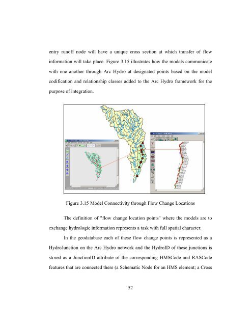
- Page 49 and 50: geodatabase (under Arc Hydro format
- Page 51 and 52: 3.4.4 External Execution of HEC-RAS
- Page 53 and 54: analysis. In particular, GIS has be
- Page 55 and 56: 3.5.3 Model-Specific ElementsA geog
- Page 57 and 58: Figure 3.11 Geographic and Hydrolog
- Page 59 and 60: For HEC-RAS, the connectivity is ac
- Page 61: cross sections in the hydraulic mod
- Page 65 and 66: from the geodatabase back into the
- Page 67 and 68: Figure 3.19 Relationship Classes fo
- Page 69 and 70: Figure 3.20 DSS Time Series content
- Page 71 and 72: Figure 3.22 Extended Time Series Co
- Page 73 and 74: Figure 3.23 Creating a Flow File fr
- Page 75 and 76: etween the HEC-DSS file system and
- Page 77 and 78: The more specific steps for the pos
- Page 79 and 80: Chapter 4 Map2Map Components4.1 MOD
- Page 81 and 82: A subset of NEXRAD time series data
- Page 83 and 84: A folder location is also provided
- Page 85 and 86: Figure 4.4 Radar2GDB Model Componen
- Page 87 and 88: ecords. Figure 4.6 illustrates the
- Page 89 and 90: Figure 4.8 Time Series Tables and R
- Page 91 and 92: having different formats and that a
- Page 93 and 94: Part E: Time Interval of stored dat
- Page 95 and 96: execution time and for their corres
- Page 97 and 98: on the steps needed to transfer the
- Page 99 and 100: Len_sBTime (I): The length of the s
- Page 101 and 102: 52: Invalid precision exponent spec
- Page 103 and 104: methods: user hyetograph, user gage
- Page 105 and 106: Once the hyetograph is defined (for
- Page 107 and 108: The resulting runoff hydrograph is
- Page 109 and 110: Thus, the time period for the entir
- Page 111 and 112: After the ZSRTS subroutine is execu
- Page 113 and 114:
Figure 4.12 HMSCaller Model Compone
- Page 115 and 116:
ased on a process handle (a program
- Page 117 and 118:
These simple command line statement
- Page 119 and 120:
To programmatically accomplish this
- Page 121 and 122:
to provide the hydraulic input for
- Page 123 and 124:
information into the extended Arc H
- Page 125 and 126:
The HydroJunction, used for connect
- Page 127 and 128:
Once the identification of flow cha
- Page 129 and 130:
As with the GDB2HMSDSS, the first t
- Page 131 and 132:
4.1.7 Time Series ExtractionOnce th
- Page 133 and 134:
accomplish this have been developed
- Page 135 and 136:
straight forward for all time stamp
- Page 137 and 138:
As opposed to HEC-DSS, the Arc Hydr
- Page 139 and 140:
Table 4.4: Variable Type Equivalenc
- Page 141 and 142:
ZCAT DSS subroutines) and stored in
- Page 143 and 144:
Table 4.5: Time Interval Equivalenc
- Page 145 and 146:
There are not specific valid values
- Page 147 and 148:
catalog list. For the DSS2GDB appli
- Page 149 and 150:
4.1.9.1 Opening the HEC-DSS fileThe
- Page 151 and 152:
channel (the hydraulic representati
- Page 153 and 154:
the model if the new configuration
- Page 155 and 156:
the main program as a public module
- Page 157 and 158:
Then, the RASCaller application acc
- Page 159 and 160:
Figure 4.31 ProjectName Property in
- Page 161 and 162:
Figure 4.33 RunSteady Method in RAS
- Page 163 and 164:
Figure 4.34 ExportGIS Method in RAS
- Page 165 and 166:
data structures delivered by every
- Page 167 and 168:
The two most well-known models for
- Page 169 and 170:
The water surface elevations obtain
- Page 171 and 172:
Once the water surface elevations f
- Page 173 and 174:
Generate a suitable water surface m
- Page 175 and 176:
Figure 4.42 2 Foot-Contour Lines fo
- Page 177 and 178:
Figure 4.43 Rosillo Creek’s terra
- Page 179 and 180:
standard ArcGIS tool), is used in M
- Page 181 and 182:
By doing this, the water surface el
- Page 183 and 184:
Figure 4.49 Create Flood Polygon Mo
- Page 185 and 186:
Int OperationThe Integer operation
- Page 187 and 188:
case that was developed for Map2Map
- Page 189 and 190:
contours (isohyetals) or by interpo
- Page 191 and 192:
design storm input given its possib
- Page 193 and 194:
Figure 4.55 Workflow for Extracting
- Page 195 and 196:
for it. Finally, the DigitalStorm2H
- Page 197 and 198:
model for water resources (Maidment
- Page 199 and 200:
Hydro, the HydroJunctionHasCrossSec
- Page 201 and 202:
involved in the transformation of r
- Page 203 and 204:
process model in sequence. For the
- Page 205 and 206:
5.6 A TRUE SPATIAL APPROACHAutomate
- Page 207 and 208:
time series between NEXRAD, the HEC
- Page 209 and 210:
value of the entire runoff hydrogra
- Page 211 and 212:
case study. Bigger watersheds (abov
- Page 213 and 214:
The first step consists in installi
- Page 215 and 216:
3.7 Map2Map UsageAll of the model b
- Page 217 and 218:
Congratulations! You have successfu
- Page 219 and 220:
Once the simplified version of Arc
- Page 221 and 222:
cells that cover your study area an
- Page 223 and 224:
Second, the user needs to modify th
- Page 225 and 226:
Appendix BMap2Map CD Content1 CD Da
- Page 227 and 228:
o hmsproj - contains folders with H
- Page 229 and 230:
Goodchild, M.F., Steyaert, L.T., an
- Page 231 and 232:
Olsen R. J., Beling, P. A., Lambert
- Page 233 and 234:
Werner, M. G. F. 2001. Impact of gr