- Page 1 and 2:
Version 6.0EnglishLeica TPS1200+Sys
- Page 3 and 4:
Table of ContentsIn this manual Cha
- Page 5 and 6:
20 Interfaces, Ports, Devices 12520
- Page 7 and 8:
1 User Interface1.1 KeyboardKeysKey
- Page 9 and 10:
1.3 Operating PrinciplesKeyboard an
- Page 11 and 12:
IconDescriptionLOCK active. Prism l
- Page 13:
RCS • RCS settings are displayed.
- Page 16 and 17:
Real-time deviceandReal-time status
- Page 18 and 19:
18 TPS1200+ User Interface
- Page 20 and 21:
2.2 USER KeyDescription • The USE
- Page 22 and 23:
Field Option DescriptionRCS Mode T
- Page 24 and 25:
StepDescription7. Centre the instru
- Page 26 and 27:
4.3 SmartStation SetupSetup step-by
- Page 28 and 29:
4.4 Instrument Setup for Remote Con
- Page 30 and 31:
StepDISTRECALLDescription(F2) to me
- Page 32 and 33:
CLOSE (F4) and OPEN (F4)To change b
- Page 34 and 35:
34 TPS1200+ Manage... - Getting Sta
- Page 36 and 37:
7.2 Creating a New Job/Editing a Jo
- Page 38 and 39:
MANAGEXX JobCoord SystempageMANAGEX
- Page 40 and 41:
8.2 Point Management8.2.1 Creating
- Page 42 and 43:
MANAGEXX Point,Code pageThe setting
- Page 44 and 45:
8.2.2 Mean PageDescription • Vari
- Page 46 and 47:
ColumndHtDescriptionThe height dist
- Page 48 and 49:
8.3.2 Creating a New Line/Area/Edit
- Page 50 and 51:
MANAGEEdit Line: Line ID,Points pag
- Page 52 and 53:
Field Option DescriptionAlways avai
- Page 54 and 55:
54 TPS1200+ Manage...\Data
- Page 56 and 57:
9.2 Creating a New Code/Editing a C
- Page 58 and 59:
Field Option DescriptionBegin LineW
- Page 60 and 61:
Field Option Description• To star
- Page 62 and 63:
10.2 Combining Linework and CodingD
- Page 64 and 65:
Step Field Description for thematic
- Page 66 and 67:
11.2 Creating a New Coordinate Syst
- Page 68 and 69:
11.3 Transformations/Ellipsoids/Pro
- Page 70 and 71:
Field Option Description Choicelist
- Page 72 and 73:
72 TPS1200+ Manage...\Coordinate Sy
- Page 74 and 75:
12.2 Creating a New Configuration S
- Page 76 and 77:
76 TPS1200+ Manage...\Configuration
- Page 78 and 79:
13.2 Creating a New Reflector/Editi
- Page 80 and 81:
14.2 Exporting ASCII DataDescriptio
- Page 82 and 83:
14.3 Exporting DXF DataGeneralAcces
- Page 84 and 85:
84 TPS1200+ Convert...\Export Data
- Page 86 and 87:
15.2 Importing ASCII/GSI DataRequir
- Page 88 and 89:
15.3 Importing DXF DataRequirements
- Page 90 and 91:
90 TPS1200+ Convert...\Copy Points
- Page 92 and 93:
17.1.2 Creating a New ID Template/E
- Page 94 and 95:
Description of fieldsField Option D
- Page 96 and 97:
Next stepPAGE (F6) changes to the L
- Page 98 and 99:
Field Option Description User input
- Page 100 and 101:
Description of fieldsField Option D
- Page 102 and 103:
Field Option DescriptionLow Vis Alw
- Page 104 and 105:
CONFIGURESearch Windows,ATR Window
- Page 106 and 107:
18.4 TPS CorrectionsDescriptionAcce
- Page 108 and 109:
Next stepCONT (F1) returns to the s
- Page 110 and 111:
18.6 Instrument IDDescriptionAccess
- Page 112 and 113:
Description of fieldsField Option D
- Page 114 and 115:
19.2 Hot Keys & User MenuDescriptio
- Page 116 and 117:
19.3 Units & FormatsDescriptionAcce
- Page 118 and 119:
Field Option DescriptionDay.Month.Y
- Page 120 and 121:
19.5 Lights, Display, Beeps, TextDe
- Page 122 and 123:
19.6 Start Up & Power DownDescripti
- Page 124 and 125:
124 TPS1200+ Config...\General Sett
- Page 127 and 128:
20.2 PortsDescription • The instr
- Page 129 and 130:
20.3.2 Configuring a DeviceDescript
- Page 131 and 132:
20.3.4 Creating a New Device/Editin
- Page 133 and 134:
21 Config...\Interfaces... - Editin
- Page 135 and 136: 21.3 RCS ModeDescriptionAccessCONFI
- Page 137 and 138: 21.5 GPS RTKDescription • The set
- Page 139 and 140: 22 Config...\Interfaces... - Contro
- Page 141 and 142: Next stepIF the digitalcellular pho
- Page 143 and 144: 22.3 Radios for GPS Real-TimeDescri
- Page 145 and 146: 22.5 RS232DescriptionConfigure RS23
- Page 147 and 148: 22.7 InternetDescriptionConfig...\I
- Page 149 and 150: 22.8 Creating a New Station to Dial
- Page 151 and 152: 22.9 Creating a New Server to Conne
- Page 153 and 154: 23 Config...\SmartStation...23.1 Re
- Page 156 and 157: CONFIGUREAdditional RoverOptions,NT
- Page 158 and 159: Field Option DescriptionTime,Observ
- Page 160 and 161: 23.3 Satellite SettingsDescriptionA
- Page 162 and 163: 23.4 Local Time ZoneDescriptionAcce
- Page 164 and 165: 23.6 Logging of Raw ObsDescription
- Page 166: 24.2 Transfer Objects...Description
- Page 169 and 170: 24.4 Calculator and File ViewerRefe
- Page 171: 24.6 Field to OfficeDescriptionSupp
- Page 175 and 176: 25.3 STATUS: System InformationAcce
- Page 177 and 178: 25.4 STATUS: Interfaces...Descripti
- Page 179 and 180: 25.6 STATUS: Level & Laser PlummetD
- Page 181 and 182: ColumnAzmthS/N 1 and S/N 2Descripti
- Page 183 and 184: FieldDescriptionAvailable for .Seco
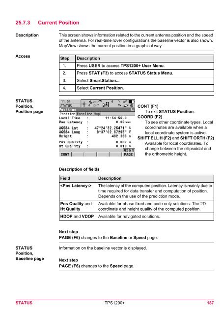
- Page 185: Field • For , or with :The anten
- Page 189 and 190: 25.7.4 Logging StatusDescriptionAcc
- Page 191 and 192: 25.7.5 SmartAntenna System InfoAcce
- Page 193 and 194: 26 NTRIP via Internet26.1 OverviewD
- Page 195 and 196: Step Description12. USER13. STAT (F
- Page 197 and 198: Step DescriptionCheck the Internet
- Page 199 and 200: StepDescription Indicates if charge
- Page 201 and 202: 27 Menu TreeMenu treeMAIN MENU||—
- Page 203 and 204: IndexAAbsolute coordinate differenc
- Page 205 and 206: Dynamic ATR window ................
- Page 207 and 208: Line codeFilter ...................
- Page 209 and 210: Start time ........................