The results for area 5 aga<strong>in</strong> demonstrate that the apparent risk to houses near to the burgledhome is particularly dramatic. However, <strong>in</strong> common with area 3 the risk of burglary appearsto communicate over a greater distance <strong>in</strong> this area.Table 2.21: Weekly Knox analysis for area 5 (values <strong>in</strong> bold are statistically significantaccord<strong>in</strong>g to the residual scores (not shown), N=311)WEEKS1.00 2.00 3.00 4.00 5.00 6.00 7.00 8.00 9.00 10.00 11.00 12.00100 5.29 1.14 0.86 0.71 0.71 0.67 0.83 0.29 0.71 1.17 0.50 0.33200 2.31 1.77 1.14 0.77 0.69 1.08 0.92 0.85 0.46 1.38 1.00 0.45300 2.20 1.21 0.80 0.86 1.07 0.62 0.36 1.14 0.64 1.29 1.67 0.92400 2.33 1.07 0.87 0.71 1.21 0.29 0.71 0.71 0.86 1.00 1.15 0.83500 1.64 1.50 1.43 0.69 0.86 0.54 1.38 1.15 0.77 1.08 0.58 1.08600 1.11 1.06 0.72 0.76 0.94 1.00 1.56 0.88 1.29 1.12 0.53 0.73700 1.53 0.72 0.63 0.89 0.72 0.88 1.24 0.72 1.00 1.12 0.38 1.06800 1.47 0.68 0.79 0.83 1.17 0.94 0.82 1.06 1.06 0.56 1.44 0.94900 1.32 1.11 1.32 0.89 1.00 1.06 1.59 1.06 0.78 0.89 0.81 0.631000 0.72 1.06 1.22 1.41 0.89 1.18 1.41 1.47 0.71 1.12 1.40 1.07Thus, although caution is required when <strong>in</strong>terpret<strong>in</strong>g the above results due to the samplesizes <strong>in</strong>volved, the results suggest different profiles across the different areas. That said, forevery area, the largest Knox ratio (and residual) was for the shortest space-time <strong>in</strong>terval,suggest<strong>in</strong>g the ubiquity of this f<strong>in</strong>d<strong>in</strong>g at all levels of geographic resolution.Temporal variation?For a number of reasons, it is possible that the profile of the communication of risk for eacharea may change over time. For <strong>in</strong>stance, different offenders may adopt dist<strong>in</strong>ct forag<strong>in</strong>gstrategies. Some may prefer to commit <strong>crime</strong>s very close to previously burgled homesimmediately afterwards, whereas others may prefer to commit them nearby after a short<strong>in</strong>terval has elapsed. This may particularly affect the time-space pattern<strong>in</strong>g of burglary if newoffenders move <strong>in</strong>to an area, were arrested or move elsewhere. Also, it is possible that thedevelopment or demolition of hous<strong>in</strong>g would change the availability of targets and hence thepatterns of <strong>crime</strong>.For this reason, Knox profiles were generated for Mansfield and ‘A’ Division for sequentialtime periods to determ<strong>in</strong>e whether or not the profiles do change, and if so <strong>in</strong> what way. To dothis, for each area a Knox profile was generated us<strong>in</strong>g twelve months worth of data. Next, anew profile was generated us<strong>in</strong>g twelve months of data but which, compared to the previousanalysis, <strong>in</strong>cluded the next two weeks of data, and excluded the oldest two weeks of data.This was repeated 22 times for each area. Thus the analysis was completed us<strong>in</strong>g a mov<strong>in</strong>gw<strong>in</strong>dow of data, which <strong>in</strong>cluded new data on each iteration. The results of the analyses werethen animated and compared.The general pattern of results suggested that while the Knox profiles did vary a little from oneprofile to the next they tended to rema<strong>in</strong> stable over time. This may suggest that, <strong>in</strong> general,offenders adopt similar forag<strong>in</strong>g patterns or that a sufficiently small proportion of activeburglars were ever <strong>in</strong> custody to modify the overall picture. There is ubiquity of the f<strong>in</strong>d<strong>in</strong>gthat burglary clusters <strong>in</strong> space and time, as evidenced by recent research that shows thatthese patterns are apparent <strong>in</strong> all other countries for which data have so far been analysedsuch as the UK, US, Netherlands, New Zealand and Australia (Johnson et al., 2006). Oneexplanation for the differences <strong>in</strong> the profiles observed for each area could relate todifferences <strong>in</strong> target density between the different areas. Thus, the risk of victimisation maycommunicate over greater distances <strong>in</strong> areas <strong>in</strong> which houses are more dispersed, whereasrisks may communicate over shorter distances where houses are spatially concentrated and17
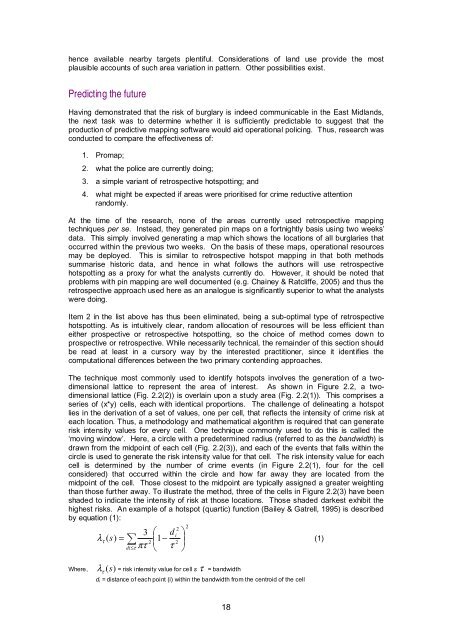
hence available nearby targets plentiful. Considerations of land use provide the mostplausible accounts of such area variation <strong>in</strong> pattern. Other possibilities exist.Predict<strong>in</strong>g the futureHav<strong>in</strong>g demonstrated that the risk of burglary is <strong>in</strong>deed communicable <strong>in</strong> the East Midlands,the next task was to determ<strong>in</strong>e whether it is sufficiently predictable to suggest that theproduction of predictive <strong>mapp<strong>in</strong>g</strong> software would aid <strong>operational</strong> polic<strong>in</strong>g. Thus, research wasconducted to compare the effectiveness of:1. Promap;2. what the police are currently do<strong>in</strong>g;3. a simple variant of retrospective hotspott<strong>in</strong>g; and4. what might be expected if areas were prioritised for <strong>crime</strong> reductive attentionrandomly.At the time of the research, none of the areas currently used retrospective <strong>mapp<strong>in</strong>g</strong>techniques per se. Instead, they generated p<strong>in</strong> maps on a fortnightly basis us<strong>in</strong>g two weeks’data. This simply <strong>in</strong>volved generat<strong>in</strong>g a map which shows the locations of all burglaries thatoccurred with<strong>in</strong> the previous two weeks. On the basis of these maps, <strong>operational</strong> resourcesmay be deployed. This is similar to retrospective hotspot <strong>mapp<strong>in</strong>g</strong> <strong>in</strong> that both methodssummarise historic data, and hence <strong>in</strong> what follows the authors will use retrospectivehotspott<strong>in</strong>g as a proxy for what the analysts currently do. However, it should be noted thatproblems with p<strong>in</strong> <strong>mapp<strong>in</strong>g</strong> are well documented (e.g. Cha<strong>in</strong>ey & Ratcliffe, 2005) and thus theretrospective approach used here as an analogue is significantly superior to what the analystswere do<strong>in</strong>g.Item 2 <strong>in</strong> the list above has thus been elim<strong>in</strong>ated, be<strong>in</strong>g a sub-optimal type of retrospectivehotspott<strong>in</strong>g. As is <strong>in</strong>tuitively clear, random allocation of resources will be less efficient thaneither prospective or retrospective hotspott<strong>in</strong>g, so the choice of method comes down toprospective or retrospective. While necessarily technical, the rema<strong>in</strong>der of this section shouldbe read at least <strong>in</strong> a cursory way by the <strong>in</strong>terested practitioner, s<strong>in</strong>ce it identifies thecomputational differences between the two primary contend<strong>in</strong>g approaches.The technique most commonly used to identify hotspots <strong>in</strong>volves the generation of a twodimensionallattice to represent the area of <strong>in</strong>terest. As shown <strong>in</strong> Figure 2.2, a twodimensionallattice (Fig. 2.2(2)) is overla<strong>in</strong> upon a study area (Fig. 2.2(1)). This comprises aseries of (x*y) cells, each with identical proportions. The challenge of del<strong>in</strong>eat<strong>in</strong>g a hotspotlies <strong>in</strong> the derivation of a set of values, one per cell, that reflects the <strong>in</strong>tensity of <strong>crime</strong> risk ateach location. Thus, a methodology and mathematical algorithm is required that can generaterisk <strong>in</strong>tensity values for every cell. One technique commonly used to do this is called the‘mov<strong>in</strong>g w<strong>in</strong>dow’. Here, a circle with a predeterm<strong>in</strong>ed radius (referred to as the bandwidth) isdrawn from the midpo<strong>in</strong>t of each cell (Fig. 2.2(3)), and each of the events that falls with<strong>in</strong> thecircle is used to generate the risk <strong>in</strong>tensity value for that cell. The risk <strong>in</strong>tensity value for eachcell is determ<strong>in</strong>ed by the number of <strong>crime</strong> events (<strong>in</strong> Figure 2.2(1), four for the cellconsidered) that occurred with<strong>in</strong> the circle and how far away they are located from themidpo<strong>in</strong>t of the cell. Those closest to the midpo<strong>in</strong>t are typically assigned a greater weight<strong>in</strong>gthan those further away. To illustrate the method, three of the cells <strong>in</strong> Figure 2.2(3) have beenshaded to <strong>in</strong>dicate the <strong>in</strong>tensity of risk at those locations. Those shaded darkest exhibit thehighest risks. An example of a hotspot (quartic) function (Bailey & Gatrell, 1995) is describedby equation (1):223 ⎛ d ⎞( ) = 1 ⎟2 ⎜ −iλτs ∑(1)2di≤τπτ ⎝ τ ⎠Where, λτ(s)= risk <strong>in</strong>tensity value for cell s τ = bandwidthd i = distance of each po<strong>in</strong>t (i) with<strong>in</strong> the bandwidth from the centroid of the cell18
- Page 2 and 3: 1. UCL JILL DANDO INSTITUTE OF CRIM
- Page 4 and 5: ContentsAcknowledgementsExecutive s
- Page 6 and 7: 2.5 Illustration of a simple neares
- Page 8 and 9: Project outcomesPatterns of burglar
- Page 10 and 11: those that involved collaboration w
- Page 12 and 13: 1. IntroductionThis report represen
- Page 14 and 15: optimally calibrated system, the go
- Page 16 and 17: e ij = n .j x n i.nWhere, e ij is t
- Page 18 and 19: Table 2.2: Knox ratios for Mansfiel
- Page 20 and 21: Table 2.6: Monte-Carlo results for
- Page 22 and 23: Table 2.10: Weekly Knox ratios for
- Page 24 and 25: Table 2.14: Monte-Carlo results for
- Page 26 and 27: Figure 2.1: The five policing areas
- Page 30 and 31: The bandwidth used to generate the
- Page 32: a densely populated urban area this
- Page 35 and 36: Table 2.24: Average number of crime
- Page 37 and 38: Patrolling efficiencyAs discussed e
- Page 39 and 40: 3. Tactical options and selecting a
- Page 41 and 42: Selecting a pilot siteThe decision
- Page 43 and 44: Table 3.2: Tactical options matrixT
- Page 45 and 46: Type ofinterventionStudyUse ofintel
- Page 47 and 48: Other potential tactical optionsAt
- Page 49 and 50: 4. System development and evolution
- Page 51 and 52: the same time of day as each other
- Page 53 and 54: unfortunately, implementation or us
- Page 55 and 56: any tactical options were employed
- Page 57 and 58: the end of the pilot. In addition t
- Page 59 and 60: Figure 5.1: Promap dissemination pr
- Page 61 and 62: the busy schedule of the new Divisi
- Page 63 and 64: Tactical deliveryCommand Team daily
- Page 65 and 66: Table 5.3: Number of respondents wh
- Page 67 and 68: permitted, up to four plain clothed
- Page 69 and 70: observation made by those who used
- Page 71 and 72: A simple time-series analysis (see
- Page 73 and 74: Two approaches were used to compute
- Page 75 and 76: Figure 6.3: Changes in the proporti
- Page 77 and 78: Figure 6.5: Changes in the proporti
- Page 79 and 80:
With respect to implementation real
- Page 81 and 82:
ReferencesAggresti, A. (1996) An In
- Page 83 and 84:
Johnson, S.D., Summers, L., and Pea
- Page 85 and 86:
Appendix 1. The information technol
- Page 87 and 88:
Figure A1.2: Stand-alone applicatio
- Page 89 and 90:
Recommendations that may be realise
- Page 91 and 92:
Section 1: knowledge and understand
- Page 93 and 94:
Extra Comments (please outline any
- Page 95 and 96:
In relation to the evaluation of in
- Page 97 and 98:
Time-series analysisFor the purpose
- Page 99 and 100:
Figure A3.1: Changes in the spatial
- Page 101 and 102:
Figure A3.2: Lorenz curves showing
- Page 103 and 104:
To recapitulate and elaborate, the
- Page 105 and 106:
Concluding comments on methodThe te
- Page 107 and 108:
Figure A5.2: An enlargement of the
- Page 109 and 110:
Figure A5.6: Prospective map magnif
- Page 111:
Produced by the Research Developmen


