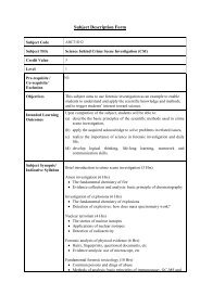
r - The Hong Kong Polytechnic University
r - The Hong Kong Polytechnic University
r - The Hong Kong Polytechnic University

Create successful ePaper yourself
Turn your PDF publications into a flip-book with our unique Google optimized e-Paper software.
flexural tower modes, (vi) longitudinal flexural tower modes and (vii) torsional flexural tower modes. From<br />
these types of vibration mode shapes and their modal participation factors, the major modes and frequencies of<br />
vibration under different types of dynamic loads such as wind and seismic can be identified for<br />
observation/monitoring. <strong>The</strong> customized software tools are also required to compare the measured results with<br />
the analyzed results. <strong>The</strong> flow diagram of the software tools for global dynamic features monitoring is shown in<br />
Figure 23.<br />
J. Customized Software Tools for Stay Forces Monitoring [Ref.15 and 29]<br />
<strong>The</strong> stay forces monitoring refers to the monitoring of the dynamic features of stay cables, hence the tensile<br />
forces and stability against wind-rain-induced vibrations. This monitoring requires the execution of field<br />
vibration measurement works on the stay cables. <strong>The</strong> equipment and facilities required are the PDAS-1, the<br />
removal accelerometers and the associated portable power and signal cables. During measurement, two<br />
accelerometers (one for measurement and the other for control/calibration) should be used and in order to<br />
minimize the measurement errors induced by the stay cable deck anchorage, the first accelerometer should be<br />
fixed as a distance of no less than six meters away from the edge of the stay cable deck anchorage. Customized<br />
software tools are required to: (i) extract the in-plane flexural frequencies, out-of-plane frequencies and<br />
longitudinal frequencies of the stay cable, hence determine the tensile force in stay cable under ambient<br />
vibration measurement, (ii) determine the logarithmic decrement, hence determine the Scruton number basing<br />
on manual-excited forced-free vibration measurement, and (iii) plot the analyzed results and together with the<br />
corresponding analysis/design/as-built values. <strong>The</strong> flow diagram of the software tools for stay forces monitoring<br />
is shown in Figure 24.<br />
K. Customized Software Tools for Tendon Forces Monitoring [Ref. 15]<br />
<strong>The</strong> tendon forces monitoring refers to the monitoring of the forces in the eight tendons per deck-girder-box,<br />
which are designed for enhancing the deck strength at the interfacing regions between steel/concrete in the<br />
side-span. A total of 32 tendons (each of 37 strands) are used and therefore 32 nos. of tensio magnetic gauges<br />
are deployed, i.e. one for each tendon. <strong>The</strong> tensio magnetic gauge used is EM sensor (EM-T-160) with<br />
dimension 400mm length x 220 mm overall diameter for 160 mm strand bundle at a measuring stress range of<br />
1770 MPa and the data logger equipped is PowerStress P-500-08, which is a 8-channel data logger with a<br />
sampling rate of 0.1 Hz. <strong>The</strong> customized software tools for tendon forces monitoring are comparatively simply<br />
as solely time-average statistics analysis is required. <strong>The</strong> flow diagram of the software tools for tendon forces<br />
monitoring is shown in Figure 25.<br />
L. Customized Software Tools for Displacements Monitoring [Ref. 15 and 19]<br />
<strong>The</strong> displacement monitoring of Stonecutters Bridge is based on GPS (rover stations and reference stations) and<br />
tiltmeters. <strong>The</strong> GPS (rover stations – for measurement of bridge motions) are installed at tower-tops and on two<br />
edges of the bridge-deck section at 1/4, 1/2 and 3/4 of main span; whereas the tiltmeters are installed in both<br />
towers at H (or tower-top), 2/3H, 1/3H and 0/3H (or deck-level), where H is the tower-height above the deck<br />
level. <strong>The</strong> tiltmeters are also installed on the internal walls of the upper side-span piers. All tiltmeters are<br />
bi-axial tiltmeters. <strong>The</strong> GPS (reference stations – 2 nos., one for master reference and one for backup reference)<br />
are installed at roof-top of East Portal Building which is around 1 km from Stonecutters Bridge. All time-series<br />
data from different types of sensors are synchronized and time-tagged to the GPS (reference stations) with a<br />
minimum accuracy of ±0.1 second. Each GPS is installed at a stiff GPS post so that the GPS installed at the<br />
post-top should have the same motion as the measurement point at the post-base. In order to minimize the<br />
multi-path effects at ground/base level and/or avoidance of obstruction induced by the passage of high-side<br />
vehicles, the heights of the GPS posts at deck-levels, tower-tops and roof-top are around 4 meters, 3 meters and<br />
1.5 meters respectively. Both GPS (digital sensors) and tiltmeters (analogue sensors) are configured to have the<br />
same sampling rate of 20 Hz. Figure 26 illustrates the arrangement of GPS (rover stations) at deck-levels.<br />
All GPS are Leica GPS, in which the GPS (rover station) is GX1230 GG GNSS receiver with AX1202 GG<br />
GNSS antenna; whereas the GPS (reference station) is GX1230 GG GNSS receiver with AT504 GG<br />
Choke-Ring GNSS antenna. <strong>The</strong> acronym of GNSS (or Global Navigation Satellite System) is a technique that<br />
supports the satellite-signals from both systems of American GPS and Russian GLONASS. <strong>The</strong> horizontal<br />
measurement accuracy of GPS is 3mm±0.5ppm (for static mode) and 10mm±1ppm (for real-time kinematic<br />
mode); whereas the vertical measurement accuracy of GPS is 6m±1ppm (for static mode) and 20mm±1ppm (for<br />
real-time kinematic mode). <strong>The</strong> tiltmeter used is Model 716-2A Wall Mount Tiltmeter from Applied<br />
Geomechanics, which has a resolution of 0.1 μ-radian.<br />
-252-