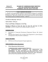
Covington, Kentucky Zoning Ordinance - The City of Covington
Covington, Kentucky Zoning Ordinance - The City of Covington
Covington, Kentucky Zoning Ordinance - The City of Covington

Create successful ePaper yourself
Turn your PDF publications into a flip-book with our unique Google optimized e-Paper software.
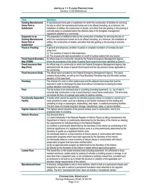
Article 11 Flood ProtectionSection 11.02 DefinitionsTermExisting ManufacturedHome Park orSubdivisionExpansion to anExisting ManufacturedHome Park orSubdivisionFlood or FloodingFlood Hazard BoundaryMap (FHBM)Flood Insurance RateMap (Firm)Flood Insurance StudyFloodwayFloorFunctionally DependentFacilityHighest Adjacent GradeHistoric StructureLowest FloorManufactured HomeDefinitionA manufactured home park or subdivision for which the construction <strong>of</strong> facilities for servicingthe lots on which the manufactured homes are to be affixed (including, at a minimum, theinstallation <strong>of</strong> utilities, the construction <strong>of</strong> streets, and either final site grading or the pouring <strong>of</strong>concrete pads) is completed before the effective date <strong>of</strong> the floodplain managementregulations adopted by a community.<strong>The</strong> preparation <strong>of</strong> additional sites by the construction <strong>of</strong> facilities for servicing the lots onwhich the manufactured homes are to be affixed (including, at a minimum, the installation <strong>of</strong>utilities, the construction <strong>of</strong> streets, and either final site grading or the pouring <strong>of</strong> concretepads.)A general and temporary condition <strong>of</strong> partial or complete inundation <strong>of</strong> normally dry landareas from:(1) <strong>The</strong> overflow <strong>of</strong> inland or tidal waterways;(2) <strong>The</strong> unusual and rapid accumulation or run<strong>of</strong>f <strong>of</strong> surface waters from any source.An <strong>of</strong>ficial map <strong>of</strong> a community, issued by the Federal Emergency Management Agency,where the boundaries <strong>of</strong> the areas <strong>of</strong> special flood hazard have been identified as Zone A.An <strong>of</strong>ficial map <strong>of</strong> a community on which the Federal Emergency Management Agency hasdelineated both the areas <strong>of</strong> special flood hazard and the risk premium zones applicable tothe community.<strong>The</strong> <strong>of</strong>ficial report provided by the Federal Emergency Management Agency. <strong>The</strong> reportcontains flood pr<strong>of</strong>iles, as well as the Flood Boundary Floodway map and the water surfaceelevation <strong>of</strong> the base flood.<strong>The</strong> channel <strong>of</strong> a river or other watercourse and the adjacent land areas that must bereserved in order to discharge the base flood without cumulatively increasing the watersurface elevation more than one foot.<strong>The</strong> top surface <strong>of</strong> an enclosed area in a building (including basement), i.e., top <strong>of</strong> slab inconcrete slab construction or top <strong>of</strong> wood flooring in wood frame construction. <strong>The</strong> term doesnot include the floor <strong>of</strong> a garage used solely for parking vehicles.A facility which cannot be used for its intended purpose unless it is located or carried out inclose proximity to water, such as a docking or port facility necessary for the loading andunloading <strong>of</strong> cargo or passengers, shipbuilding, ship repair, or seafood processing facilities.<strong>The</strong> term does not include long-term storage, manufacture, sales, or service facilities.<strong>The</strong> highest natural elevation <strong>of</strong> the ground surface, prior to construction, next to theproposed walls <strong>of</strong> a building.Any structure that is:(1) Listed individually in the National Register <strong>of</strong> Historic Places (a listing maintained by theDepartment <strong>of</strong> Interior) or preliminarily determined by the Secretary <strong>of</strong> the Interior as meetingthe requirements for individual listing on the National Register;(2) Certified or preliminarily determined by the Secretary <strong>of</strong> the Interior as contributing to thehistorical significance <strong>of</strong> a registered historic zone or a zone preliminarily determined by theSecretary to qualify as a registered historic zone;(3) Individually listed on a local inventory <strong>of</strong> historic places in communities with historicpreservation programs which have been approved by the Secretary <strong>of</strong> the Interior;(4) Individually listed on a local inventory <strong>of</strong> historic places in communities with historicpreservation program that have been certified either:(a) By an approved state program as determined by the Secretary <strong>of</strong> the Interior;(b) Directly by the Secretary <strong>of</strong> the Interior in states without approved programs.<strong>The</strong> lowest floor or the lowest enclosed area (including basement). An unfinished or floodresistant enclosure, usable solely for parking <strong>of</strong> vehicles or building access or storage, in anarea other than a basement area, is not considered a building’s lowest floor, provided suchan enclosure is not built so as to render the structure in violation <strong>of</strong> the applicable nonelevationdesign requirements <strong>of</strong> this section.A structure, transportable in one or more sections, which is built on a permanent chassis anddesigned for use with or without a permanent foundation when attached to the requiredutilities. <strong>The</strong> term “manufactured home” does not include a “recreational vehicle.”<strong>Covington</strong>, <strong>Kentucky</strong><strong>Zoning</strong> <strong>Ordinance</strong> Draft: 6/22/05Page 11-2