Piano Sociale - Comunità Alto Garda e Ledro
Piano Sociale - Comunità Alto Garda e Ledro
Piano Sociale - Comunità Alto Garda e Ledro

Create successful ePaper yourself
Turn your PDF publications into a flip-book with our unique Google optimized e-Paper software.
<strong>Piano</strong> <strong>Sociale</strong> di Comunità 2011-13 - Comunità <strong>Alto</strong> <strong>Garda</strong> e <strong>Ledro</strong><br />
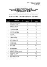
DRO<br />
Superficie (km2) 27,94<br />
Popolazione residente al 31.12.2010 4.435*<br />
Densità di popolazione (abitanti/ km2) 159<br />
Altitudine del comune (m.s.l.m.) 123<br />
Altitudine min. (m.s.l.m.) 100<br />
Altitudine max. (m.s.l.m.) 1.536<br />
LEDRO<br />
Superficie (km2) 154,6<br />
Popolazione residente al 31.12.2010 5.523*<br />
Densità di popolazione (abitanti/ km2) 36<br />
Altitudine del comune (m.s.l.m.) 660<br />
Altitudine min. (m.s.l.m.) 67<br />
Altitudine max. (m.s.l.m.) 2.254<br />
NAGO-TORBOLE<br />
Superficie (km2) 28,43<br />
Popolazione residente al 31.12.2010 2.793*<br />
Densità di popolazione (abitanti/ km2) 98<br />
Altitudine del comune (m.s.l.m.) 85<br />
Altitudine min. (m.s.l.m.) 67<br />
Altitudine max. (m.s.l.m.) 2.079<br />
RIVA DEL GARDA<br />
Superficie (km2) 42,46<br />
Popolazione residente al 31.12.2010 16.170*<br />
Densità di popolazione (abitanti/ km2) 381<br />
Altitudine del comune (m.s.l.m.) 67<br />
Altitudine min. (m.s.l.m.) 67<br />
Altitudine max. (m.s.l.m.) 2.080<br />
TENNO<br />
Superficie (km2) 28,29<br />
Popolazione residente al 31.12.2010 2.029*<br />
Densità di popolazione (abitanti/ km2) 72<br />
Altitudine del comune (m.s.l.m.) 428<br />
Altitudine min. (m.s.l.m.) 159<br />
Altitudine max. (m.s.l.m.) 2.147<br />
* Fonte dei dati sulla popolazione: Servizio Statistica PAT<br />
19