- Page 1 and 2:
PENNY HILL WIND FARM ENVIRONMENTAL
- Page 3 and 4:
PREFACE This Environmental Statemen
- Page 5 and 6:
TABLE OF CONTENTS PREFACE .........
- Page 7 and 8:
1. INTRODUCTION THIS DOCUMENT 1.1 T
- Page 9 and 10:
a summary of the assessment, includ
- Page 11 and 12:
to ensure that every home is adequa
- Page 13 and 14:
PROJECT OBJECTIVES 1.27 The project
- Page 15 and 16:
and enhanced wildlife habitats. In
- Page 17 and 18:
2.6 The proposed turbines would be
- Page 19 and 20:
Meteorological Monitoring 2.17 Wind
- Page 21 and 22:
2.26 Tracks between turbines are re
- Page 23 and 24:
include an appropriate control mech
- Page 25 and 26:
3. ENVIRONMENTAL IMPACT ASSESSMENT
- Page 27 and 28:
SCOPING AND CONSULTATION Submission
- Page 29 and 30:
elevant to each assessment are incl
- Page 31 and 32:
Impact on Landscape Impact on TV Re
- Page 33 and 34:
Regulations, it is important that t
- Page 35 and 36:
4. SITE SELECTION AND DESIGN DESCRI
- Page 37 and 38:
45m AGL as viable (using the BERR U
- Page 39 and 40:
4.26 Again there are no scheduled a
- Page 41 and 42:
environmental sieves must be consid
- Page 43 and 44:
Achieve acceptable noise levels fro
- Page 45 and 46:
5. CONSTRUCTION, OPERATION AND DECO
- Page 47 and 48:
Reinstatement around turbines; Cons
- Page 49 and 50:
5.21 If necessary, to prevent mud e
- Page 51 and 52:
turbine would automatically be appl
- Page 53 and 54:
PART 2: SUMMARY OF ENVIRONMENTAL IM
- Page 55 and 56:
ASSESSMENT METHODOLOGY Published Gu
- Page 57 and 58:
6.15 It is acknowledged that beyond
- Page 59 and 60:
6.30 The viewpoints were selected t
- Page 61 and 62:
6.42 The assessment records no effe
- Page 63 and 64:
Table 6.3: Photomontages A photomon
- Page 65 and 66:
6.51 With regards to the landscape
- Page 67 and 68:
No Change No notable loss or altera
- Page 69 and 70:
IMPACT SIGNIFICANCE 6.70 The ultima
- Page 71 and 72:
designated are clearly outweighed b
- Page 73 and 74:
6.91 ENV2.2 Interest Outside Statut
- Page 75 and 76:
PLANNING DESIGNATIONS 6.99 All rele
- Page 77 and 78:
6.115 In the wider 20km study area
- Page 79 and 80:
BASELINE CONDITIONS Site Specific L
- Page 81 and 82:
oundaries are marked by hedges. On
- Page 83 and 84:
Landscape Character Areas (LCAs) ar
- Page 85 and 86:
Countryside Commission and English
- Page 87 and 88:
Table 6.5: Sensitivity of Surroundi
- Page 89 and 90:
Laughton Common; Todwick Grange; To
- Page 91 and 92:
6.178 The Rotherham Roundwalk passe
- Page 93 and 94:
6.195 Tables 6.6 identifies the vie
- Page 95 and 96:
ASSESSMENT OF EFFECTS EFFECTS ON EX
- Page 97 and 98:
Operational Phase 6.219 As discusse
- Page 99 and 100:
The distance between the character
- Page 101 and 102:
distance, the turbines would be bar
- Page 103 and 104:
6.256 Therefore, it is considered t
- Page 105 and 106:
Nature and Magnitude of Constructio
- Page 107 and 108:
6.283 It should be noted that a num
- Page 109 and 110:
Decommissioning Phase 6.299 The onl
- Page 111 and 112:
6.317 Where there are clear views o
- Page 113 and 114:
6.334 From properties on the easter
- Page 115 and 116:
6.350 Therefore there would be a lo
- Page 117 and 118:
6.365 Therefore there would be no a
- Page 119 and 120:
Decommissioning Phase 6.381 The onl
- Page 121 and 122:
of the M18, the turbines would resu
- Page 123 and 124:
6.413 The top of the meteorological
- Page 125 and 126:
such the only properties within the
- Page 127 and 128:
would also be visible but at this d
- Page 129 and 130:
Significance of Construction Effect
- Page 131 and 132:
Nature and Magnitude of Operational
- Page 133 and 134:
Nature and Magnitude of Constructio
- Page 135 and 136:
6.507 The view towards the site fro
- Page 137 and 138:
Nature and Magnitude of Constructio
- Page 139 and 140:
number of locations along the publi
- Page 141 and 142:
6.557 The photograph presented in F
- Page 143 and 144:
Significance of Construction Effect
- Page 145 and 146:
6.591 The ZTV and wireframe suggest
- Page 147 and 148:
6.609 The development would result
- Page 149 and 150:
Reference Number Viewpoint Location
- Page 151 and 152:
There is no view from ground floor
- Page 153 and 154:
6.630 Beyond 5km any views of the P
- Page 155 and 156:
motorway. As the M1 approaches the
- Page 157 and 158:
6.658 Therefore there would be a mo
- Page 159 and 160:
6.671 The overall magnitude of chan
- Page 161 and 162:
6.682 From these isolated locations
- Page 163 and 164:
Table 6.9: Summary of Theoretical S
- Page 165 and 166:
6.697 An iterative design approach
- Page 167 and 168:
there is already considerable movem
- Page 169 and 170:
6.724 It is the professional opinio
- Page 171 and 172:
6.739 It has also been assessed tha
- Page 173 and 174:
Planning Policy Statement (PPS) 9:
- Page 175 and 176:
Phase 1 Habitat Survey; Bat Surveys
- Page 177 and 178:
experienced ecologists, holding a c
- Page 179 and 180:
7.17 Residual effects of large adve
- Page 181 and 182:
7.30 Two transects were surveyed wh
- Page 183 and 184:
No water was visible until the vege
- Page 185 and 186:
area is not considered to be a popu
- Page 187 and 188: considered to be minor negative - t
- Page 189 and 190: likelihood of this occurrence the i
- Page 191 and 192: Bats 7.70 It is likely that there w
- Page 193 and 194: 7.83 Where hedgerow sections are re
- Page 195 and 196: there are plans for light work such
- Page 197 and 198: Impact (Construction) Soil and wate
- Page 199 and 200: Impact (Decommissioning) Ecological
- Page 201 and 202: 8. ORNITHOLOGY INTRODUCTION 8.1 Thi
- Page 203 and 204: Sheffield City Ecology Unit; Sheffi
- Page 205 and 206: Very High (International); High (Na
- Page 207 and 208: 8.34 Of the five species, one is in
- Page 209 and 210: eed bunting, grey partridge, starli
- Page 211 and 212: eeding season so that site compound
- Page 213 and 214: Potential Effect Significance witho
- Page 215 and 216: 9.7 For night time periods the reco
- Page 217 and 218: industrial noise exceeds those abou
- Page 219 and 220: Receptor Easting (m) Northing (m) E
- Page 221 and 222: Morthen (H1) Brampton-en-le-morthen
- Page 223 and 224: Morthen (H1) Brampton-en-lemorthen
- Page 225 and 226: 9.37 The manufacturer of the turbin
- Page 227 and 228: Cumulative Effects - consideration
- Page 229 and 230: Visual Assessment of Wind Farms - B
- Page 231 and 232: farm may be viewed, whether the tur
- Page 233 and 234: given to either the nearest turbine
- Page 235 and 236: from the proposed development (whic
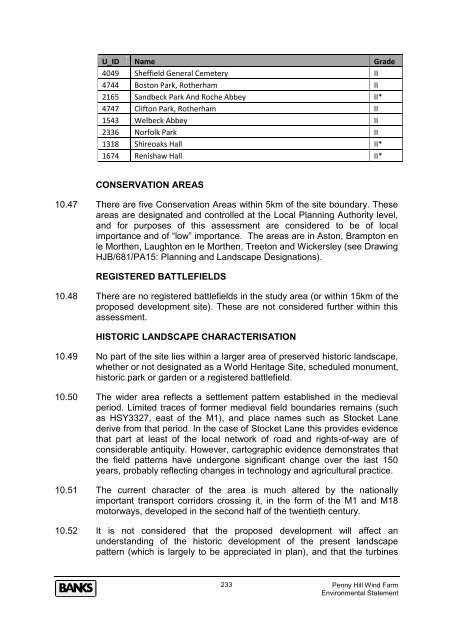
- Page 237: Table 10.6 - Grade I and II* Listed
- Page 241 and 242: SCHEDULE ANCIENT MONUMENTS 10.63 Th
- Page 243 and 244: of the proposed development to the
- Page 245 and 246: considered to be “negligible” i
- Page 247 and 248: neighbouring properties of the sett
- Page 249 and 250: not being considered significant fo
- Page 251 and 252: CUMULATIVE IMPACT ASSESSMENT 10.110
- Page 253 and 254: PART 3: DESCRIPTION OF OTHER EFFECT
- Page 255 and 256: „The Environmental Statement shou
- Page 257 and 258: oth lanes on the eastern approach t
- Page 259 and 260: A631 Bawtry Road, Hellaby - 25,442
- Page 261 and 262: PROPOSED TRANSPORT DATA Proposed Tr
- Page 263 and 264: 11.38 Based on the traffic levels i
- Page 265 and 266: Table 11.4: Peak Increases in Traff
- Page 267 and 268: Extended Servicing - One visit per
- Page 269 and 270: Route 5 - M1 Junction 33 to M1 Junc
- Page 271 and 272: Figure 11.2: The Penny Hill Site an
- Page 273 and 274: High Volts Wind Farm, Hartlepool 11
- Page 275 and 276: MITIGATION however, likely to be lo
- Page 277 and 278: The strategic road network will be
- Page 279 and 280: 11.104 It is not considered that vi
- Page 281 and 282: Figure 12.1: Penny Hill Site and Ci
- Page 283 and 284: GAMSTON 12.17 Gamston is a licensed
- Page 285 and 286: SUMMARY OF EFFECTS 12.34 It has bee
- Page 287 and 288: 13.6 The FRA has been based on a de
- Page 289 and 290:
13.21 A Coal Authority Mining Repor
- Page 291 and 292:
FLOODING FROM SURFACE WATER DRAINAG
- Page 293 and 294:
equired, there is no requirement to
- Page 295 and 296:
links, 3 T-Mobile links, 5 Vodafone
- Page 297 and 298:
Mll Telecom Ltd - Responded stating
- Page 299 and 300:
15. SHADOW FLICKER INTRODUCTION 15.
- Page 301 and 302:
PREDICTED EFFECTS 15.10 Table 15.1
- Page 303 and 304:
„health effects arising from shad
- Page 305 and 306:
16. OTHER ISSUES INTRODUCTION 16.1
- Page 307 and 308:
deliver effective environmental man
- Page 309 and 310:
falling from the blades and therefo
- Page 311 and 312:
Similarly, there is no statutory se
- Page 313:
All fields containing turbines woul


