- Page 1 and 2:
PLANNING FOR A SUSTAINABLE EUROPE?
- Page 3 and 4:
ABSTRACT OF THE DISSERTATION Planni
- Page 5 and 6:
ACKNOWLEDGEMENTS My thanks are due
- Page 7 and 8:
TABLE OF CONTENTS Abstract Acknowle
- Page 9 and 10:
7.7 Conclusions and Consequences 30
- Page 11 and 12:
LIST OF FIGURES Figures Page 1.1 Ke
- Page 13 and 14:
2 1.1 In Search of a Sustainable Tr
- Page 15 and 16:
4 well as ideological ones. Serious
- Page 17 and 18:
6 1.3 Situating the Study within th
- Page 19 and 20:
8 makes it much more difficult to d
- Page 21 and 22:
10 national institution whose legit
- Page 23 and 24:
12 Table 1.1: The Three Levels of E
- Page 25 and 26:
14 Case studies are often accused o
- Page 27 and 28:
16 In adapting this concept of “m
- Page 29 and 30:
18 1.6 Personal Motivations for Cho
- Page 31 and 32:
20 qualifying as “unbiased” is
- Page 33 and 34:
22 Union transport decision-making,
- Page 35 and 36:
24 consistent with the needs assess
- Page 37 and 38:
26 I structured the resulting inqui
- Page 39 and 40:
28 decision-makers. But when focusi
- Page 41 and 42:
30 influence of the EU in the candi
- Page 43 and 44:
32 on multi-location politicking an
- Page 45 and 46:
34 and related propositions form th
- Page 47 and 48:
36 information, and evasion of publ
- Page 49 and 50:
38 maintenance and construction cos
- Page 51 and 52:
40 Printed on October 31, 2002 Last
- Page 53 and 54:
42 relationship between transport,
- Page 55 and 56:
44 elements are knowledge control,
- Page 57 and 58:
46 2.2.2 Macroeconomic aspects of t
- Page 59 and 60:
48 existing businesses is reduced.
- Page 61 and 62:
50 the qualitative aspects of the i
- Page 63 and 64:
52 European researchers warned that
- Page 65 and 66:
54 In examining the difficult quest
- Page 67 and 68:
56 activity from one place to anoth
- Page 69 and 70:
58 The earliest meaning of sustain
- Page 71 and 72:
60 The underdevelopment debates of
- Page 73 and 74:
62 Kousis et al. 1997) makes the im
- Page 75 and 76:
64 to other social scientists. For
- Page 77 and 78:
66 Figure 2.2 The Three Dimensions
- Page 79 and 80:
68 A recent definition provided by
- Page 81 and 82:
70 The Vancouver principles are als
- Page 83 and 84:
72 2.5 Two Ill-Defined Concepts? We
- Page 85 and 86:
74 “We are all Greens now” unat
- Page 87 and 88:
76 a frequently quoted definition,
- Page 89 and 90:
78 concept aims to integrate aspect
- Page 91:
80 influence is reflected in severa
- Page 94 and 95:
83 and policy-making. For these Hab
- Page 96 and 97:
85 Pointing to the ultimate conting
- Page 98 and 99:
87 Allmendinger (2002b:77), in a re
- Page 100 and 101:
89 everything but one-sided interpr
- Page 102 and 103:
91 green consciousness” as the re
- Page 104 and 105:
93 course, also scholars propagatin
- Page 106 and 107:
95 practitioners and a majority of
- Page 108 and 109:
97 strongly agree with these author
- Page 110 and 111:
99 Instead, Baker et al. subsumes t
- Page 112 and 113:
101 policy analysts to built scient
- Page 114 and 115:
103 beliefs, notions of validity an
- Page 116 and 117:
105 Printed Thursday, October 31, 2
- Page 118 and 119:
107 and capture the most important
- Page 120 and 121:
109 4.2 Ecological Modernization: T
- Page 122 and 123:
111 modernization as “the discour
- Page 124 and 125:
113 metabolism, implies major or ba
- Page 126 and 127:
115 defining it as one of two theor
- Page 128 and 129:
117 modernization is about “what
- Page 130 and 131:
119 and World Bank-funded Global En
- Page 132 and 133:
121 The automobile lobby, of course
- Page 134 and 135:
123 external environmental and soci
- Page 136 and 137:
125 The Australian planning theoris
- Page 138 and 139:
127 responsible for rising levels o
- Page 140 and 141:
129 principle) for the development
- Page 142 and 143:
131 automobility as part and parcel
- Page 144 and 145:
133 company Deutsche Bahn is now of
- Page 146 and 147:
135 In related studies, car acciden
- Page 148 and 149:
137 (2001:2) recently summarized:
- Page 150 and 151:
139 excellent, discourse- and rheto
- Page 152 and 153:
141 investments in Central Europe.
- Page 154 and 155:
143 the “communicative rationalit
- Page 156 and 157:
145 by government regulation and fu
- Page 158 and 159:
147 industry (certain segments), bi
- Page 160 and 161:
149 Table 4.3 “Brown” Agenda ve
- Page 162 and 163:
151 or the European Investment Bank
- Page 164 and 165:
153 sustainable transport. Quoting
- Page 166 and 167:
155 “on the move” while the wea
- Page 168 and 169:
157 higher levels of education and
- Page 170 and 171:
159 In sum, political economy argum
- Page 172 and 173:
161 Table 4.4 The Eight Points of D
- Page 174 and 175:
163 International, for example, dem
- Page 176 and 177:
165 regions in the world and the ge
- Page 178 and 179:
167 Man on a bicycle can go three o
- Page 180 and 181:
169 Policy arguments in favor for l
- Page 182 and 183:
171 infrastructures with regard to
- Page 184 and 185:
173 controversial, issue, since man
- Page 186 and 187:
175 Last modified on September 20,
- Page 188 and 189:
177 on EU Research Framework Progra
- Page 190 and 191:
179 development (March 1995) stress
- Page 192 and 193:
181 5.2.3 From the Maastricht Treat
- Page 194 and 195:
183 The 1997 Treaty of Amsterdam (T
- Page 196 and 197:
185 The 1998 Decision is particular
- Page 198 and 199:
187 developments.” This de-coupli
- Page 200 and 201:
189 environmentalists also strongly
- Page 202 and 203:
191 directly focus on transport iss
- Page 204 and 205:
193 foods and subsidized intensive
- Page 206 and 207:
195 (as opposed to viewing transpor
- Page 208 and 209: 197 in the medium to long term due
- Page 210 and 211: 199 document stands out in that it
- Page 212 and 213: 201 improving quality,” and “im
- Page 214 and 215: 203 infrastructure charging systems
- Page 216 and 217: 205 For example, the new White Pape
- Page 218 and 219: 207 This online refusal to consider
- Page 220 and 221: 209 are seen as being intimately re
- Page 222 and 223: 211 transport-related policies, the
- Page 224 and 225: 213 5.5 The EU’s Research Framewo
- Page 226 and 227: 215 Table 5.2 Transport-relevant Re
- Page 228 and 229: 217 perhaps should not, be united i
- Page 230 and 231: 219 Printed on Thursday, October 31
- Page 232 and 233: 221 longstanding, ongoing and mutua
- Page 234 and 235: 223 the Social Science Research Cen
- Page 236 and 237: 225 contradictions of EU decision-m
- Page 238 and 239: 227 6.2.3 Enlargement (Widening) Th
- Page 240 and 241: 229 sustainability is necessarily b
- Page 242 and 243: 231 four poorest member states (Gre
- Page 244 and 245: 233 creator of an idea or storyline
- Page 246 and 247: 235 The 1990s saw the start of the
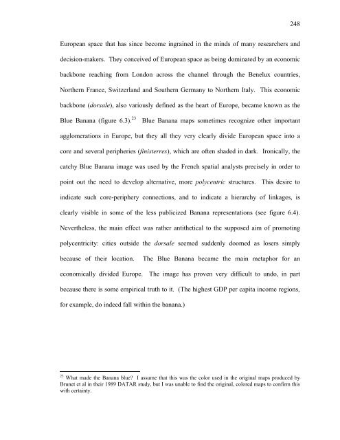
- Page 248 and 249: 237 the poorer member states to agr
- Page 250 and 251: 239 A Cohesion Fund set up by the C
- Page 252 and 253: 241 importance of economies of scal
- Page 254 and 255: 243 more precise, less optimistic a
- Page 256 and 257: 245 based European Federation for T
- Page 260 and 261: 249 Figure 6.3 The Blue Banana I: A
- Page 262 and 263: 251 at the Informal Council of Mini
- Page 264 and 265: 253 urban systems are to be found i
- Page 266 and 267: 255 In particular, ERT’s 1984 rep
- Page 268 and 269: 257 ERT soon created the myth that
- Page 270 and 271: 259 Regardless of these different m
- Page 272 and 273: 261 Once the “Missing Links” st
- Page 274 and 275: 263 most simple form, it is an unqu
- Page 276 and 277: 265 For roads, it might be a bypass
- Page 278 and 279: 267 agglomerations in the core, the
- Page 280 and 281: 269 dissenters of the view that reg
- Page 282 and 283: 271 Printed Sunday, November 17, 20
- Page 284 and 285: 273 between member states, and pros
- Page 286 and 287: 275 having been an intergovernmenta
- Page 288 and 289: 277 links are investigated in any f
- Page 290 and 291: 279 selection, there was no actual
- Page 292 and 293: 281 European ministerial meeting pr
- Page 294 and 295: 283 25,310 km for the rail sector a
- Page 296 and 297: 285 7.4 The Transport Infrastructur
- Page 298 and 299: 287 of the politically defined corr
- Page 300 and 301: 289 Figure 7.5 TINA Rail Network So
- Page 302 and 303: 291 Figure 7.7 TINA Network Hungary
- Page 304 and 305: 293 It is our opinion that the TINA
- Page 306 and 307: 295 In Poland, internationally reno
- Page 308 and 309:
297 example, the range was in fact
- Page 310 and 311:
299 The question of priorities is s
- Page 312 and 313:
301 actual choice considering futur
- Page 314 and 315:
303 projects and the overall develo
- Page 316 and 317:
305 jeopardizing international fund
- Page 318 and 319:
307 Figure 7.9 Proposed Hungarian T
- Page 320 and 321:
309 In the case of the TINA exercis
- Page 322 and 323:
311 With regard to the TINA exercis
- Page 324 and 325:
313 Printed on Sunday, November 17,
- Page 326 and 327:
315 evaluation. 2 What is possible,
- Page 328 and 329:
317 hundreds of EU regulations, dir
- Page 330 and 331:
319 First, as far as funding for th
- Page 332 and 333:
321 8.2.2 EU Transport Sector Grant
- Page 334 and 335:
323 countries will increase substan
- Page 336 and 337:
325 is also an explicit goal. The g
- Page 338 and 339:
327 1. The Community assistance fin
- Page 340 and 341:
329 During the High-Level Meeting i
- Page 342 and 343:
331 MTME 1995) was elaborated in 19
- Page 344 and 345:
333 In fact, the World Bank agreed
- Page 346 and 347:
335 However, due to renewed shifts
- Page 348 and 349:
337 describes Polish transport sect
- Page 350 and 351:
339 that had previously received mo
- Page 352 and 353:
341 Committee, i.e. well over half
- Page 354 and 355:
343 moderate increase in private ve
- Page 356 and 357:
345 As far as mode specific details
- Page 358 and 359:
347 Hungarian National ISPA Strateg
- Page 360 and 361:
349 Table 8.4 The Széchenyi Plan
- Page 362 and 363:
351 construction contracts, and non
- Page 364 and 365:
353 There are thirteen [road sector
- Page 366 and 367:
355 Table 8.5 Overview of ISPA Tran
- Page 368 and 369:
357 most of the more problematic ch
- Page 370 and 371:
359 more up to the CEEC to make sur
- Page 372 and 373:
361 new infrastructures, regardless
- Page 374 and 375:
363 9.1 Introduction: The Significa
- Page 376 and 377:
365 reinvigorated calls to build th
- Page 378 and 379:
367 9.2.2 The Northern Section: A h
- Page 380 and 381:
369 the environment and living cond
- Page 382 and 383:
371 are then listed within the four
- Page 384 and 385:
373 more progressive variant of the
- Page 386 and 387:
375 9.4 Local and International Pro
- Page 388 and 389:
377 The permission plan and the EIA
- Page 390 and 391:
379 since only citizens or legal pe
- Page 392 and 393:
381 environmental matter. Moreover,
- Page 394 and 395:
383 9.5.5 Reexamining the impact of
- Page 396 and 397:
385 Orbital motorways do not necess
- Page 398 and 399:
387 At this point, a suitable defin
- Page 400 and 401:
389 Besides retail and industrial p
- Page 402 and 403:
391 Figure 9.2 New construction of
- Page 404 and 405:
393 city still shows a strong upwar
- Page 406 and 407:
395 Figure 9.8 Budapest’s “Stra
- Page 408 and 409:
397 upgrades in and around the Hung
- Page 410 and 411:
399 infrastructures, including the
- Page 412 and 413:
401 Printed on November 17, 2002 La
- Page 414 and 415:
403 challenging and re-evaluating p
- Page 416 and 417:
405 10.2 Summary of Previous Chapte
- Page 418 and 419:
407 contradictory and ultimately as
- Page 420 and 421:
409 storylines are closely aligned
- Page 422 and 423:
411 internationally-linked priority
- Page 424 and 425:
413 In Chapter 9, I looked at the M
- Page 426 and 427:
415 guideposts for interpreting rea
- Page 428 and 429:
417 explanations of why “in the e
- Page 430 and 431:
419 How far this leverage is then p
- Page 432 and 433:
421 decision-making, and instead re
- Page 434 and 435:
423 or “congestion.” This is wh
- Page 436 and 437:
425 concentration of economic activ
- Page 438 and 439:
427 10.4.1 Taking Action on Strateg
- Page 440 and 441:
429 brought forward not only by man
- Page 442 and 443:
431 Table 10.1 A Two-Dimensional
- Page 444 and 445:
433 space. Transport loans are usua
- Page 446 and 447:
435 APPENDICES, GLOSSARY, BIBLIOGRA
- Page 448 and 449:
437 Table A.2 EIB Transport Loans t
- Page 450 and 451:
439 Table A.4 EBRD and IBRD Transpo
- Page 452 and 453:
441 Annex II: List of Key Contacts
- Page 454 and 455:
443 CEC Tom Robbert SCR, EU lending
- Page 456 and 457:
445 NGO Hana Rihkovsky Comm. of Eur
- Page 458 and 459:
447 ”Poverty Alleviation through
- Page 460 and 461:
449 Annotated Glossary of Terms, Ac
- Page 462 and 463:
451 competitiveness and growth of E
- Page 464 and 465:
453 Pan-European Corridors See “H
- Page 466 and 467:
455 Bibliography Aglietta, M. (1979
- Page 468 and 469:
457 the Infrastructure Studies Grou
- Page 470 and 471:
459 Centre For European Policy Stud
- Page 472 and 473:
461 —— (2001a). A Sustainable E
- Page 474 and 475:
463 Dierkes, M., U. Hoffmann, et al
- Page 476 and 477:
465 European Parliament. European R
- Page 478 and 479:
467 Münster, Lit Verlag. Giunta, A
- Page 480 and 481:
469 Henderson, K., Ed. (1999). Back
- Page 482 and 483:
471 Kesselring, S. (2001). Mobile P
- Page 484 and 485:
473 Race and Class Barriers to Mobi
- Page 486 and 487:
475 Europe: a cross-national compar
- Page 488 and 489:
477 Studies 36(11): 1849-1858. Prug
- Page 490 and 491:
479 Transport Reviews 20(3): 369-38
- Page 492 and 493:
481 Future. New York, United Nation
- Page 494:
483 DEIKE PETERS EDUCATION: CURRICU