- Page 1 and 2:
Atlantic Climate Adaptation Solutio
- Page 3 and 4:
GOVERNMENT OF NEWFOUNDLAND AND LABR
- Page 5 and 6:
June 13, 2012 AMEC Project #TA11127
- Page 7 and 8:
EXECUTIVE SUMMARY The Government of
- Page 9 and 10:
Assessing the Need for New or Updat
- Page 11 and 12:
SUMMARY The Government of Newfoundl
- Page 13 and 14:
Land Use Change A pre-cursor effort
- Page 15 and 16:
fresh water from the Arctic south a
- Page 17 and 18:
watershed, which appears to already
- Page 19 and 20:
RECOMMENDATION SUMMARY Infrastructu
- Page 21 and 22:
7. It is recommended that WRMD deve
- Page 23 and 24:
TABLE OF CONTENTS PAGE EXECUTIVE SU
- Page 25 and 26:
7.3 References for Assess Need for
- Page 27 and 28:
LIST OF TABLES Table 2-1. Flood Eve
- Page 29 and 30:
LIST OF FIGURES Figure 2-1. Water R
- Page 31 and 32:
1. OVERVIEW In the 1980‟s, under
- Page 33 and 34:
Floodway Floodway Fringe Climate Ch
- Page 35 and 36:
2. Task B - Updated Flood Events In
- Page 37 and 38:
Management Framework for Canada def
- Page 39 and 40:
The „Types of Events‟ field is
- Page 41 and 42:
Field Damage Estimate by Community
- Page 43 and 44:
Arrangements 10 (DFAA) damage estim
- Page 45 and 46:
Storm # General Location Year Seaso
- Page 47 and 48:
2.3.2 Weather Events - Annual Occur
- Page 49 and 50:
Figure 2-6. Storm Occurrence by Yea
- Page 51 and 52:
Figure 2-8. Storm Occurrence by Mon
- Page 53 and 54:
Type of Event (Grouped) % Occurrenc
- Page 55 and 56:
Figure 2-11. Flood Occurrence by Se
- Page 57 and 58:
Coastal Flooding Coastal Flooding a
- Page 59 and 60:
September is associated, presently,
- Page 61 and 62:
3. Task C - Assess Existing Flood R
- Page 63 and 64:
Gaudon‟s Brook / Cold Brook Steph
- Page 65 and 66:
3.3.2.1 Community Flood Watersheds
- Page 67 and 68:
3.3.2.3 Earth Observation for Susta
- Page 69 and 70:
Figure 3-3. Graphical model of land
- Page 71 and 72:
Original EOSD Classes Shadow Water
- Page 73 and 74:
surrounding areas were also evaluat
- Page 75 and 76:
Watershed Community Total Area Fore
- Page 77 and 78:
correct). Of the 90 accuracy assess
- Page 79 and 80:
Figure 3-6. GCM sectors selected to
- Page 81 and 82:
Figure 3-7. Percentage change of pr
- Page 83 and 84:
The results for temperature are sim
- Page 85 and 86:
Area Labrador West Central East Sum
- Page 87 and 88:
West sees slightly larger winter in
- Page 89 and 90:
These increases, though slight, in
- Page 91 and 92:
Classification Maximum Sustained Su
- Page 93 and 94:
Since air flow around high pressure
- Page 95 and 96:
10 9 8 7 6 Total Number of Tropical
- Page 97 and 98: One of the reasons for this increas
- Page 99 and 100: Figure 3-19. Frequency of Named Sto
- Page 101 and 102: Figure 3-21. Change in Mean Sea Lev
- Page 103 and 104: The net long term sea level effect
- Page 105 and 106: Southern Oscillation (ENSO). The AM
- Page 107 and 108: middle of North America as it would
- Page 109 and 110: e a higher incidence of tropical st
- Page 111 and 112: extreme will be considered. Areas t
- Page 113 and 114: Storms weaken rapidly once they mak
- Page 115 and 116: Figure 3-27. Selected Hurricane and
- Page 117 and 118: o o a Category 2 Hurricane making l
- Page 119 and 120: o Because winter temperatures show
- Page 121 and 122: Worst Case Scenarios This section
- Page 123 and 124: 5. A hurricane making landfall on t
- Page 125 and 126: Standards Association 21 recommends
- Page 127 and 128: WRMD has defined a preference for h
- Page 129 and 130: The hydrographic network was used t
- Page 131 and 132: 4.1.8 Flood History Identification
- Page 133 and 134: Watershed Slope The slope attribute
- Page 135 and 136: such as number of flood events at a
- Page 137 and 138: Deer Lake Placentia Codroy Steady B
- Page 139 and 140: TA1112733 page 109
- Page 141 and 142: 5.2 Methods The methodology used fo
- Page 143 and 144: Reported Event Damages Storm# Locat
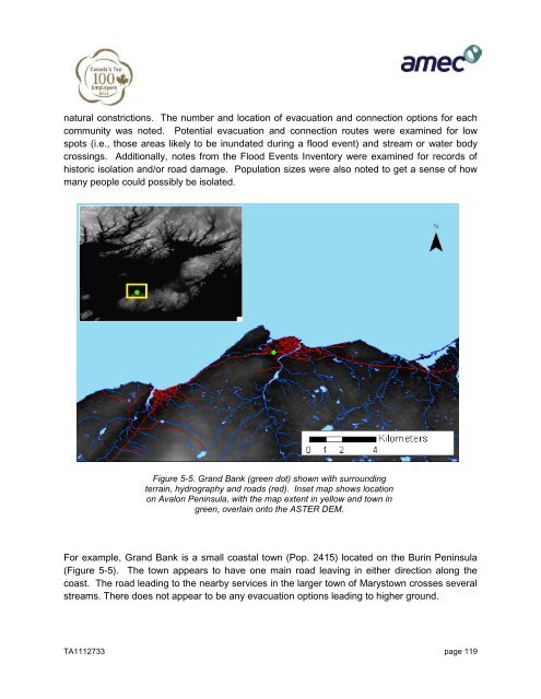
- Page 145 and 146: Given the reported damages resultin
- Page 147: Figure 5-3. Storm tracks for select
- Page 151 and 152: 5.5.2 Community Exposure to Physica
- Page 153 and 154: Community Number of Events 2011 Pop
- Page 155 and 156: Community Access Notes Confinement
- Page 157 and 158: Brook and Deer Lake are both locate
- Page 159 and 160: Warning Systems 1. It is recommende
- Page 161 and 162: source of flood vulnerabilities com
- Page 163 and 164: Figure 6-2. Newfoundland Digital El
- Page 165 and 166: communities ( Gillams, Hughes Brook
- Page 167 and 168: Sub-region Precipitation Climate Ch
- Page 169 and 170: Analysis of the socio-economic data
- Page 171 and 172: East-2 Coastal communities line nea
- Page 173 and 174: 6.2.2 Potential Strategies Table 6-
- Page 175 and 176: 6.3 Mitigation Recommendations Base
- Page 177 and 178: Table 6-5 presents the range of ave
- Page 179 and 180: West-3, West-4, and Central-3 These
- Page 181 and 182: Mitigation Strategy Cost to Impleme
- Page 183 and 184: Sub-region Watershed Characteristic
- Page 185 and 186: TA1112733 page 155
- Page 187 and 188: Music and Caya, 2007 Richter and Ba
- Page 189 and 190: http://www.arcgis.com/home/item.htm
- Page 191 and 192: Rank Community Name LGP# 82 Massey
- Page 193 and 194: Rank Community Name LGP# 252 Little
- Page 195 and 196: Rank Community Name LGP# 423 Thornl
- Page 197 and 198: TA1112733 page 167
- Page 199 and 200:
FOX ISLAND RIVER-POINT GALLANTS GEO
- Page 201 and 202:
GEORGE'S BROOK-MILTON GOOBIES GRAND
- Page 203 and 204:
TA1112733 page 173
- Page 205 and 206:
Flood # Storm # General Location St
- Page 207 and 208:
Flood # Storm # General Location St
- Page 209 and 210:
Flood # Storm # General Location St
- Page 211 and 212:
Flood # Storm # General Location St
- Page 213 and 214:
Flood # Storm # General Location St
- Page 215 and 216:
Flood # Storm # General Location St
- Page 217 and 218:
Flood # Storm # General Location St
- Page 219 and 220:
Flood # Storm # General Location St
- Page 221 and 222:
Flood # Storm # General Location St
- Page 223 and 224:
Flood # Storm # General Location St
- Page 225 and 226:
Flood # Storm # General Location St
- Page 227 and 228:
Flood # Storm # General Location St
- Page 229 and 230:
Flood # Storm # General Location St
- Page 231 and 232:
Flood # Storm # General Location St
- Page 233 and 234:
Flood # Storm # General Location St
- Page 235 and 236:
Flood # Storm # General Location St
- Page 237 and 238:
Flood # Storm # General Location St
- Page 239 and 240:
Flood # Storm # General Location St
- Page 241 and 242:
Flood # Storm # General Location St
- Page 243 and 244:
Flood # Storm # General Location St
- Page 245 and 246:
Flood # Storm # General Location St
- Page 247 and 248:
Flood # Storm # General Location St
- Page 249 and 250:
Flood # Storm # General Location St
- Page 251 and 252:
Flood # Storm # General Location St
- Page 253 and 254:
11. Appendix D IDF Curves Report TA
- Page 255 and 256:
Development of Projected Intensity-
- Page 257 and 258:
Development of Projected Intensity-
- Page 259 and 260:
Development of Projected Intensity-
- Page 261 and 262:
Development of Projected Intensity-
- Page 263 and 264:
Storm Duration Development of Proje
- Page 265 and 266:
Storm Duration Development of Proje
- Page 267 and 268:
Storm Duration Development of Proje
- Page 269 and 270:
Development of Projected Intensity-
- Page 271 and 272:
Development of Projected Intensity-
- Page 273 and 274:
Development of Projected Intensity-
- Page 275 and 276:
Development of Projected Intensity-
- Page 277 and 278:
Development of Projected Intensity-
- Page 279 and 280:
Development of Projected Intensity-
- Page 281 and 282:
Development of Projected Intensity-
- Page 283 and 284:
Development of Projected Intensity-
- Page 285 and 286:
1979 1983 1987 1991 1995 1999 2003
- Page 287 and 288:
Mean Annual Total Precipoitation, m
- Page 289 and 290:
Storm Duration Storm Duration Devel
- Page 291 and 292:
Storm Duration Storm Duration Storm
- Page 293 and 294:
Storm Duration Storm Duration Storm
- Page 295 and 296:
Storm Duration Storm Duration Storm
- Page 297 and 298:
Storm Duration Storm Duration Storm
- Page 299 and 300:
Storm Duration Storm Duration Storm
- Page 301 and 302:
Development of Projected Intensity-
- Page 303 and 304:
Development of Projected Intensity-
- Page 305 and 306:
Development of Projected Intensity-
- Page 307 and 308:
Development of Projected Intensity-
- Page 309 and 310:
Codroy Valley Watershed Topography
- Page 311 and 312:
Parson's Pond Watershed Topography
- Page 313 and 314:
Rushoon Watershed: Topography Eleva
- Page 315 and 316:
Eastern Watersheds, East Topography
- Page 317 and 318:
Eastern 54°0'0"Watersheds, West To
- Page 319 and 320:
Central Watersheds, 57°0'0"W East
- Page 321 and 322:
Central 58°0'0"W and Western Water
- Page 323 and 324:
Badger and Rushy 58°0'0"W Pond Wat
- Page 325 and 326:
Cox's Cove Watershed: Land Cover 58
- Page 327 and 328:
Ferryland Watershed Land Cover 60°
- Page 329 and 330:
49°0'0"N Glenwood-Appleton 56°0'0
- Page 331 and 332:
Parson's Pond Watershed: Land Cover
- Page 333 and 334:
Rushy Pond Watershed: 57°0'0"WLand
- Page 335 and 336:
Stephenville Crossing Watershed: La
- Page 337 and 338:
Whitbourne and Brigus Watersheds: L
- Page 339 and 340:
Eastern Watersheds 2: Land Cover Ha
- Page 341:
Eastern Watersheds, East: Land Cove