

Flood Risk and Vulnerability Analysis Project - Atlantic Climate ...
Flood Risk and Vulnerability Analysis Project - Atlantic Climate ...
Flood Risk and Vulnerability Analysis Project - Atlantic Climate ...

Create successful ePaper yourself
Turn your PDF publications into a flip-book with our unique Google optimized e-Paper software.
<strong>Flood</strong> #<br />
Storm #<br />
General<br />
Location<br />
Start Year<br />
Start Month<br />
Start Day<br />
Start Time<br />
End Year<br />
End Month<br />
End Day<br />
End Time<br />
Duration (days)<br />
Season<br />
Region<br />
LGP#<br />
Community<br />
Name<br />
Water Bodies<br />
Type of Event<br />
Rainfall<br />
Amount<br />
Snowfall<br />
amount<br />
Sea Height<br />
Jam Height<br />
Damage<br />
Estimate by<br />
Community (if<br />
known)<br />
Damage<br />
Estimate by<br />
Storm (once<br />
per storm)<br />
DFAA Damage<br />
Report<br />
DFAA Damage<br />
Report (once<br />
per storm)<br />
Homes<br />
<strong>Flood</strong>ed<br />
People<br />
Displaced<br />
Attachment<br />
Number<br />
Data Added By<br />
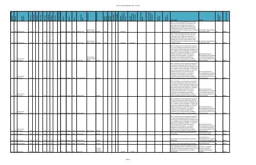
<strong>Flood</strong> Inventory Database 1950 - Present<br />
87 065 Stephenville 1973 8 2 1973 8 3 1 Summer Western 4945 Stephenville<br />
88 065 Stephenville 1973 8 2 1973 8 3 1 Summer Western 3485 Noel's Pond<br />
Warm Creek /<br />
Blanche Brook Rainfall 50.8 $70,000<br />
Warm Creek /<br />
Blanche Brook Rainfall 50.8 $70,000 $70,000<br />
Description<br />
Source<br />
MR: The worst recorded flooding in the towns<br />
history. The main highway into the town was<br />
under water <strong>and</strong> a bridge was washed out,<br />
Basements were flooded <strong>and</strong> a waterline was<br />
damaged leaving many people without water.<br />
Four families forced to evacuate due to 4-6inches Environment Canada Report<br />
of water on floor.<br />
January 8th, 1976 No AMEC<br />
MR: The worst recorded flooding in the towns<br />
history. The main highway into the town was<br />
under water <strong>and</strong> a bridge was washed out,<br />
Basements were flooded <strong>and</strong> a waterline was<br />
damaged leaving many people without water.<br />
Four families forced to evacuate due to 4-6inches<br />
of water on floor.<br />
Environment Canada Report<br />
January 8th, 1976 No AMEC<br />
89 066<br />
Port au Port<br />
Peninsula 1973 8 1 1973 8 4 3 Summer Western 1380 Deer Lake<br />
Corner Brook<br />
Stream / Bell's<br />
Brook<br />
Rainfall<br />
MR: A l<strong>and</strong>slide occurred upstream bringing 30-<br />
40 cords of pulpwood <strong>and</strong> trees down the river<br />
with the flood, several boats were dragged out to<br />
sea. Highway 47 was underwater in at least two<br />
places <strong>and</strong> a bridge was washed out. At least 4<br />
families were forced to leave their homes<br />
because of the flood waters. A number of<br />
basements were flooded as Bell's Brook<br />
overflowed. Corner Brook Stream <strong>and</strong> Bell's<br />
Brook overflowed resulting in some inundation.<br />
MR: <strong>Flood</strong>ing Events in<br />
Newfoundl<strong>and</strong> <strong>and</strong> Labrador<br />
- An Historical Perspective.<br />
Hydro technical Study of the<br />
Deer Lake Area No AMEC<br />
90 066<br />
Port au Port<br />
Peninsula 1973 8 1 1973 8 4 3 Summer Western 1681 Fox Isl<strong>and</strong> River Rainfall<br />
MR: A l<strong>and</strong>slide occurred upstream bringing 30-<br />
40 cords of pulpwood <strong>and</strong> trees down the river<br />
with the flood, several boats were dragged out to<br />
sea. Highway 47 was underwater in at least two<br />
places <strong>and</strong> a bridge was washed out. At least 4<br />
families were forced to leave their homes<br />
because of the flood waters. A number of<br />
basements were flooded as Bell's Brook<br />
overflowed. Corner Brook Stream <strong>and</strong> Bell's<br />
Brook overflowed resulting in some inundation.<br />
MR: <strong>Flood</strong>ing Events in<br />
Newfoundl<strong>and</strong> <strong>and</strong> Labrador<br />
- An Historical Perspective.<br />
Hydro technical Study of the<br />
Deer Lake Area No AMEC<br />
91 066<br />
Port au Port<br />
Peninsula 1973 8 1 1973 8 4 3 Summer Western 4945 Stephenville Rainfall<br />
MR: A l<strong>and</strong>slide occurred upstream bringing 30-<br />
40 cords of pulpwood <strong>and</strong> trees down the river<br />
with the flood, several boats were dragged out to<br />
sea. Highway 47 was underwater in at least two<br />
places <strong>and</strong> a bridge was washed out. At least 4<br />
families were forced to leave their homes<br />
because of the flood waters. A number of<br />
basements were flooded as Bell's Brook<br />
overflowed. Corner Brook Stream <strong>and</strong> Bell's<br />
Brook overflowed resulting in some inundation.<br />
MR: <strong>Flood</strong>ing Events in<br />
Newfoundl<strong>and</strong> <strong>and</strong> Labrador<br />
- An Historical Perspective.<br />
Hydro technical Study of the<br />
Deer Lake Area No AMEC<br />
92 066<br />
Port au Port<br />
Peninsula 1973 8 1 1973 8 4 3 Summer Western 3485 Noel's Pond Rainfall<br />
MR: A l<strong>and</strong>slide occurred upstream bringing 30-<br />
40 cords of pulpwood <strong>and</strong> trees down the river<br />
with the flood, several boats were dragged out to<br />
sea. Highway 47 was underwater in at least two<br />
places <strong>and</strong> a bridge was washed out. At least 4<br />
families were forced to leave their homes<br />
because of the flood waters. A number of<br />
basements were flooded as Bell's Brook<br />
overflowed. Corner Brook Stream <strong>and</strong> Bell's<br />
Brook overflowed resulting in some inundation.<br />
MR: <strong>Flood</strong>ing Events in<br />
Newfoundl<strong>and</strong> <strong>and</strong> Labrador<br />
- An Historical Perspective.<br />
Hydro technical Study of the<br />
Deer Lake Area No AMEC<br />
93 066<br />
Port au Port<br />
Peninsula 1973 8 1 1973 8 4 3 Summer Western 1200 Corner Brook Bell's Brook Rainfall<br />
94 067 St. John's 1974 8 23 1974 8 24 1 Summer Eastern 3345 Mount Pearl Rainfall<br />
MR: A l<strong>and</strong>slide occurred upstream bringing 30-<br />
40 cords of pulpwood <strong>and</strong> trees down the river<br />
with the flood, several boats were dragged out to<br />
sea. Highway 47 was underwater in at least two<br />
places <strong>and</strong> a bridge was washed out. At least 4<br />
families were forced to leave their homes<br />
because of the flood waters. A number of<br />
basements were flooded as Bell's Brook<br />
overflowed. Corner Brook Stream <strong>and</strong> Bell's<br />
Brook overflowed resulting in some inundation.<br />
Storm water runoff led to basement flooding in<br />
Mount Pearl<br />
MR: <strong>Flood</strong>ing Events in<br />
Newfoundl<strong>and</strong> <strong>and</strong> Labrador<br />
- An Historical Perspective.<br />
Hydro technical Study of the<br />
Deer Lake Area No AMEC<br />
Waterford River Area -<br />
Hydro technical Study No AMEC<br />
95 068 St. John's 1974 8 30 1974 8 30 1 Summer Eastern 3345 Mount Pearl Rainfall<br />
Several basements were flooded in Donovans<br />
Street area<br />
96 069 Corner Brook 1974 9 12 1974 9 13 1 Summer Western 1200 Corner Brook Rainfall A home on Old Humber Road was Inundated<br />
97 070 Cape Ray 1974 10 20 1974 10 20 1 Fall Eastern 905 Cape Ray<br />
Coastal<br />
<strong>Flood</strong>ing<br />
<strong>and</strong> Winds $1,000 $1,000<br />
<strong>Flood</strong>ing Events in<br />
Newfoundl<strong>and</strong> <strong>and</strong> Labrador<br />
- An Historical Perspective No AMEC<br />
Hydro technical Study of the<br />
Steady Brook Area No AMEC<br />
MR: High Seas at Cape Ray washed out 30m of<br />
track causing derailment of 2 diesel locomotives. Department of Natural<br />
High seas at Cape Ray washed out about 30 m of Resources Website,<br />
railway track causing derailment of 2 diesel<br />
locomotives.<br />
Heritage Newfoundl<strong>and</strong><br />
Website. 70 AMEC<br />
Page 6


