

Flood Risk and Vulnerability Analysis Project - Atlantic Climate ...
Flood Risk and Vulnerability Analysis Project - Atlantic Climate ...
Flood Risk and Vulnerability Analysis Project - Atlantic Climate ...

Create successful ePaper yourself
Turn your PDF publications into a flip-book with our unique Google optimized e-Paper software.
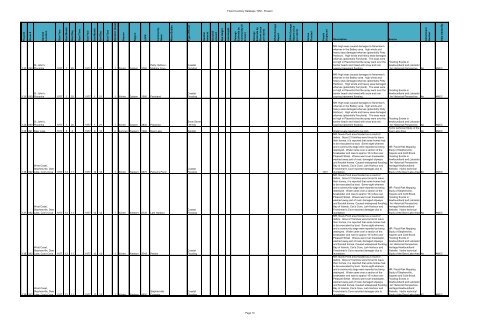
<strong>Flood</strong> #<br />
Storm #<br />
General<br />
Location<br />
Start Year<br />
Start Month<br />
Start Day<br />
Start Time<br />
End Year<br />
End Month<br />
End Day<br />
End Time<br />
Duration (days)<br />
Season<br />
Region<br />
LGP#<br />
Community<br />
Name<br />
Water Bodies<br />
Type of Event<br />
Rainfall<br />
Amount<br />
Snowfall<br />
amount<br />
Sea Height<br />
Jam Height<br />
Damage<br />
Estimate by<br />
Community (if<br />
known)<br />
Damage<br />
Estimate by<br />
Storm (once<br />
per storm)<br />
DFAA Damage<br />
Report<br />
DFAA Damage<br />
Report (once<br />
per storm)<br />
Homes<br />
<strong>Flood</strong>ed<br />
People<br />
Displaced<br />
Attachment<br />
Number<br />
Data Added By<br />
<strong>Flood</strong> Inventory Database 1950 - Present<br />
Description<br />
Source<br />
132 090<br />
St. John's,<br />
Placentia 1977 1 20 1977 1 21 1 Winter Eastern 3760<br />
Petty Harbour -<br />
Maddox Cove<br />
Coastal<br />
<strong>Flood</strong>ing<br />
MR: High seas caused damages to fisherman's<br />
wharves in the Battery area. high winds <strong>and</strong><br />
heavy seas damaged wharves (potentially Petty<br />
Harbour). High winds <strong>and</strong> heavy seas damaged<br />
wharves (potentially Ferryl<strong>and</strong>). The seas were<br />
so high in Placentia that the spray went over the<br />
barrier beach <strong>and</strong> mixed with snow <strong>and</strong> rain<br />
causing basement flooding<br />
<strong>Flood</strong>ing Events in<br />
Newfoundl<strong>and</strong> <strong>and</strong> Labrador<br />
- An Historical Perspective No AMEC<br />
133 090<br />
St. John's,<br />
Placentia 1977 1 20 1977 1 21 1 Winter Eastern 1580 Ferryl<strong>and</strong><br />
Coastal<br />
<strong>Flood</strong>ing<br />
MR: High seas caused damages to fisherman's<br />
wharves in the Battery area. high winds <strong>and</strong><br />
heavy seas damaged wharves (potentially Petty<br />
Harbour). High winds <strong>and</strong> heavy seas damaged<br />
wharves (potentially Ferryl<strong>and</strong>). The seas were<br />
so high in Placentia that the spray went over the<br />
barrier beach <strong>and</strong> mixed with snow <strong>and</strong> rain<br />
causing basement flooding<br />
<strong>Flood</strong>ing Events in<br />
Newfoundl<strong>and</strong> <strong>and</strong> Labrador<br />
- An Historical Perspective No AMEC<br />
134 090<br />
St. John's,<br />
Placentia 1977 1 20 1977 1 21 1 Winter Eastern 3800 Placentia<br />
Snow Storm<br />
/ Winds<br />
MR: High seas caused damages to fisherman's<br />
wharves in the Battery area. high winds <strong>and</strong><br />
heavy seas damaged wharves (potentially Petty<br />
Harbour). High winds <strong>and</strong> heavy seas damaged<br />
wharves (potentially Ferryl<strong>and</strong>). The seas were<br />
so high in Placentia that the spray went over the<br />
barrier beach <strong>and</strong> mixed with snow <strong>and</strong> rain<br />
causing basement flooding<br />
135 091 Deer Lake 1977 6 8 1977 6 10 2 Summer Western 1380 Deer Lake Rainfall Water levels reported to be high<br />
136 092<br />
137 092<br />
138 092<br />
139 092<br />
West Coast,<br />
Stephenville, Deer<br />
Lake, Cox's Cove 1977 12 11 1977 12 12 1 Winter Western 3675 Parson's Pond<br />
West Coast,<br />
Stephenville, Deer<br />
Lake, Cox's Cove 1977 12 11 1977 12 12 1 Winter Western 2730 Lark Harbour<br />
West Coast,<br />
Stephenville, Deer<br />
Lake, Cox's Cove 1977 12 11 1977 12 12 1 Winter Western 3745 Petites<br />
West Coast,<br />
Stephenville, Deer<br />
Lake, Cox's Cove 1977 12 11 1977 12 12 1 Winter Western 4950<br />
Stephenville<br />
Crossing<br />
Coastal<br />
<strong>Flood</strong>ing 100+<br />
Coastal<br />
<strong>Flood</strong>ing<br />
Coastal<br />
<strong>Flood</strong>ing<br />
Coastal<br />
<strong>Flood</strong>ing<br />
<strong>Flood</strong>ing Events in<br />
Newfoundl<strong>and</strong> <strong>and</strong> Labrador<br />
- An Historical Perspective No AMEC<br />
Hydro technical Study of the<br />
Deer Lake Area No AMEC<br />
MR: Noels Pond area flooded as a result of<br />
debris. About 21 families were forced to leave<br />
their homes, it is reported that some homes had<br />
to be evacuated by boat. Some eight wharves<br />
<strong>and</strong> a community stage were reported as being MR: <strong>Flood</strong> <strong>Risk</strong> Mapping<br />
destroyed. Water came over a section of the Study of Stephenville,<br />
breakwater <strong>and</strong> rose to approx 18 inches over Kippens <strong>and</strong> Cold Brook.<br />
Pleasant Street. Waves went over breakwater, <strong>Flood</strong>ing Events in<br />
washed away part of road, damaged slipways Newfoundl<strong>and</strong> <strong>and</strong> Labrador<br />
<strong>and</strong> flooded homes. Caused widespread flooding. - An Historical Perspective.<br />
Bay of Isl<strong>and</strong>s, Cox's Cove, Lark Harbour <strong>and</strong> Heritage Newfoundl<strong>and</strong><br />
Frenchman's Cove reported damages due to Website. Hydro technical<br />
inundation.<br />
Study of the Deer Lake Area 92<br />
MR: Noels Pond area flooded as a result of<br />
debris. About 21 families were forced to leave<br />
their homes, it is reported that some homes had<br />
to be evacuated by boat. Some eight wharves<br />
<strong>and</strong> a community stage were reported as being MR: <strong>Flood</strong> <strong>Risk</strong> Mapping<br />
destroyed. Water came over a section of the Study of Stephenville,<br />
breakwater <strong>and</strong> rose to approx 18 inches over Kippens <strong>and</strong> Cold Brook.<br />
Pleasant Street. Waves went over breakwater, <strong>Flood</strong>ing Events in<br />
washed away part of road, damaged slipways Newfoundl<strong>and</strong> <strong>and</strong> Labrador<br />
<strong>and</strong> flooded homes. Caused widespread flooding. - An Historical Perspective.<br />
Bay of Isl<strong>and</strong>s, Cox's Cove, Lark Harbour <strong>and</strong> Heritage Newfoundl<strong>and</strong><br />
Frenchman's Cove reported damages due to Website. Hydro technical<br />
inundation.<br />
Study of the Deer Lake Area No<br />
MR: Noels Pond area flooded as a result of<br />
debris. About 21 families were forced to leave<br />
their homes, it is reported that some homes had<br />
to be evacuated by boat. Some eight wharves<br />
<strong>and</strong> a community stage were reported as being<br />
destroyed. Water came over a section of the<br />
breakwater <strong>and</strong> rose to approx 18 inches over<br />
Pleasant Street. Waves went over breakwater,<br />
washed away part of road, damaged slipways<br />
<strong>and</strong> flooded homes. Caused widespread flooding.<br />
Bay of Isl<strong>and</strong>s, Cox's Cove, Lark Harbour <strong>and</strong><br />
Frenchman's Cove reported damages due to<br />
inundation.<br />
MR: <strong>Flood</strong> <strong>Risk</strong> Mapping<br />
Study of Stephenville,<br />
Kippens <strong>and</strong> Cold Brook.<br />
<strong>Flood</strong>ing Events in<br />
Newfoundl<strong>and</strong> <strong>and</strong> Labrador<br />
- An Historical Perspective.<br />
Heritage Newfoundl<strong>and</strong><br />
Website. Hydro technical<br />
Study of the Deer Lake Area 92<br />
AMEC<br />
AMEC<br />
AMEC<br />
AMEC<br />
Page 10


