

Flood Risk and Vulnerability Analysis Project - Atlantic Climate ...
Flood Risk and Vulnerability Analysis Project - Atlantic Climate ...
Flood Risk and Vulnerability Analysis Project - Atlantic Climate ...

Create successful ePaper yourself
Turn your PDF publications into a flip-book with our unique Google optimized e-Paper software.
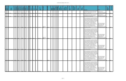
<strong>Flood</strong> #<br />
Storm #<br />
General<br />
Location<br />
Start Year<br />
Start Month<br />
Start Day<br />
Start Time<br />
End Year<br />
End Month<br />
End Day<br />
End Time<br />
Duration (days)<br />
Season<br />
Region<br />
LGP#<br />
Community<br />
Name<br />
Water Bodies<br />
Type of Event<br />
Rainfall<br />
Amount<br />
Snowfall<br />
amount<br />
Sea Height<br />
Jam Height<br />
Damage<br />
Estimate by<br />
Community (if<br />
known)<br />
Damage<br />
Estimate by<br />
Storm (once<br />
per storm)<br />
DFAA Damage<br />
Report<br />
DFAA Damage<br />
Report (once<br />
per storm)<br />
Homes<br />
<strong>Flood</strong>ed<br />
People<br />
Displaced<br />
Attachment<br />
Number<br />
Data Added By<br />
<strong>Flood</strong> Inventory Database 1950 - Present<br />
159 099 St. John's 1978 12 18 1978 12 19 1 Winter Eastern 4400 St. John's Rainfall<br />
160 100 St. John's 1979 1 8 1979 1 9 1 Winter Eastern 4400 St. John's Rainfall 38<br />
Description<br />
Considerable flooding in the city with one section<br />
of road having to be closed as a result of the<br />
heavy rains. Water was said to be up to the<br />
bumpers of some vehicles<br />
Throughout St. John's, streets, driveways <strong>and</strong><br />
some basements were flooded because of<br />
clogged drains <strong>and</strong> melting snow<br />
Source<br />
<strong>Flood</strong>ing Events in<br />
Newfoundl<strong>and</strong> <strong>and</strong> Labrador<br />
- An Historical Perspective No AMEC<br />
<strong>Flood</strong>ing Events in<br />
Newfoundl<strong>and</strong> <strong>and</strong> Labrador<br />
- An Historical Perspective No AMEC<br />
161 101 Avalon Peninsula 1979 1 28 1979 1 30 6 Winter Eastern 4400 St. John's<br />
Quidi Vidi<br />
Lake Rainfall 91<br />
MR: City crews were busy cleaning up flooded<br />
sewers <strong>and</strong> basements, entrance to The Health<br />
Sciences Centre was flooded by a nearby pond.<br />
Ice backed up water inundating the road between<br />
Robinsons <strong>and</strong> Cartyville with about 12 inches of<br />
water. A section of the Cabot Highway near<br />
Catalina was under 6 inches of water but<br />
remained passable. A stream overflowed its<br />
banks <strong>and</strong> 4 families were forced to leave their<br />
homes. Extensive damages to roads in<br />
Marystown. Extensive damages to roads, 1<br />
family had to evacuate because of rising water in<br />
main area of their home.<br />
MR: <strong>Flood</strong> <strong>Risk</strong> Mapping<br />
Study of Gould's, Petty<br />
Harbour <strong>and</strong> Ferryl<strong>and</strong>.<br />
<strong>Flood</strong>ing Events in<br />
Newfoundl<strong>and</strong> <strong>and</strong> Labrador<br />
- An Historical Perspective No AMEC<br />
162 101 Avalon Peninsula 1979 1 28 1979 1 30 6 Winter Eastern Robinson's<br />
Robinson's<br />
River<br />
Rainfall<br />
MR: City crews were busy cleaning up flooded<br />
sewers <strong>and</strong> basements, entrance to The Health<br />
Sciences Centre was flooded by a nearby pond.<br />
Ice backed up water inundating the road between<br />
Robinsons <strong>and</strong> Cartyville with about 12 inches of<br />
water. A section of the Cabot Highway near<br />
Catalina was under 6 inches of water but<br />
remained passable. A stream overflowed its<br />
banks <strong>and</strong> 4 families were forced to leave their<br />
homes. Extensive damages to roads in<br />
Marystown. Extensive damages to roads, 1<br />
family had to evacuate because of rising water in<br />
main area of their home.<br />
MR: <strong>Flood</strong> <strong>Risk</strong> Mapping<br />
Study of Gould's, Petty<br />
Harbour <strong>and</strong> Ferryl<strong>and</strong>.<br />
<strong>Flood</strong>ing Events in<br />
Newfoundl<strong>and</strong> <strong>and</strong> Labrador<br />
- An Historical Perspective No AMEC<br />
163 101 Avalon Peninsula 1979 1 28 1979 1 30 6 Winter Eastern Catalina Rainfall<br />
164 101 Avalon Peninsula 1979 1 28 1979 1 30 6 Winter Eastern 1800 Georges Brook Rainfall 4 families<br />
165 101 Avalon Peninsula 1979 1 28 1979 1 30 6 Winter Eastern 3155 Marystown Rainfall<br />
MR: City crews were busy cleaning up flooded<br />
sewers <strong>and</strong> basements, entrance to The Health<br />
Sciences Centre was flooded by a nearby pond.<br />
Ice backed up water inundating the road between<br />
Robinsons <strong>and</strong> Cartyville with about 12 inches of<br />
water. A section of the Cabot Highway near<br />
Catalina was under 6 inches of water but<br />
remained passable. A stream overflowed its<br />
banks <strong>and</strong> 4 families were forced to leave their<br />
homes. Extensive damages to roads in<br />
Marystown. Extensive damages to roads, 1<br />
family had to evacuate because of rising water in<br />
main area of their home.<br />
MR: <strong>Flood</strong> <strong>Risk</strong> Mapping<br />
Study of Gould's, Petty<br />
Harbour <strong>and</strong> Ferryl<strong>and</strong>.<br />
<strong>Flood</strong>ing Events in<br />
Newfoundl<strong>and</strong> <strong>and</strong> Labrador<br />
- An Historical Perspective No AMEC<br />
Page 13


