

Flood Risk and Vulnerability Analysis Project - Atlantic Climate ...
Flood Risk and Vulnerability Analysis Project - Atlantic Climate ...
Flood Risk and Vulnerability Analysis Project - Atlantic Climate ...

Create successful ePaper yourself
Turn your PDF publications into a flip-book with our unique Google optimized e-Paper software.
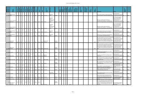
<strong>Flood</strong> #<br />
Storm #<br />
General<br />
Location<br />
Start Year<br />
Start Month<br />
Start Day<br />
Start Time<br />
End Year<br />
End Month<br />
End Day<br />
End Time<br />
Duration (days)<br />
Season<br />
Region<br />
LGP#<br />
Community<br />
Name<br />
Water Bodies<br />
Type of Event<br />
Rainfall<br />
Amount<br />
Snowfall<br />
amount<br />
Sea Height<br />
Jam Height<br />
Damage<br />
Estimate by<br />
Community (if<br />
known)<br />
Damage<br />
Estimate by<br />
Storm (once<br />
per storm)<br />
DFAA Damage<br />
Report<br />
DFAA Damage<br />
Report (once<br />
per storm)<br />
Homes<br />
<strong>Flood</strong>ed<br />
People<br />
Displaced<br />
Attachment<br />
Number<br />
Data Added By<br />
<strong>Flood</strong> Inventory Database 1950 - Present<br />
Description<br />
Source<br />
1 001<br />
Waterford River<br />
Basin 1950 10 31 1950 11 1 2 Fall Eastern 4400 St. John's<br />
Waterford<br />
River Rainfall 77<br />
Over 77mm of rainfall in 2 days led to general<br />
overbank flooding, particularly in Bowering Park<br />
<strong>Flood</strong>ing Events in<br />
Newfoundl<strong>and</strong> <strong>and</strong> Labrador<br />
- An Historical Perspective No AMEC<br />
2 002<br />
Torbay, Waterford<br />
River Basin 1951 4 10 1951 4 12 3 Spring Eastern 5125 Torbay<br />
Waterford<br />
River /<br />
Rennie's River<br />
/ Quidi Vidi<br />
River Rainfall 170<br />
MR: Heavy rainfall raised local lakes to<br />
remarkably high elevations. City streets were<br />
washed out, houses flooded <strong>and</strong> blocked traffic<br />
MR: <strong>Flood</strong> <strong>Risk</strong> Mapping<br />
Study of Goulds, Petty<br />
Harbour <strong>and</strong> Ferryl<strong>and</strong>,<br />
<strong>Flood</strong>ing Events in<br />
Newfoundl<strong>and</strong> <strong>and</strong> Labrador<br />
- An Historical Perspective No AMEC<br />
3 002<br />
Torbay, Waterford<br />
River Basin 1951 4 10 1951 4 13 3 Spring Eastern 4400 St. John's<br />
Waterford<br />
River /<br />
Rennie's River<br />
/ Quidi Vidi<br />
River Rainfall 170<br />
MR: Heavy rainfall raised local lakes to<br />
remarkably high elevations. City streets were<br />
washed out, houses flooded <strong>and</strong> blocked traffic<br />
MR: <strong>Flood</strong> <strong>Risk</strong> Mapping<br />
Study of Goulds, Petty<br />
Harbour <strong>and</strong> Ferryl<strong>and</strong>,<br />
<strong>Flood</strong>ing Events in<br />
Newfoundl<strong>and</strong> <strong>and</strong> Labrador<br />
- An Historical Perspective No AMEC<br />
4 003<br />
Waterford River<br />
Basin 1951 11 4 1951 11 5 1 Fall Eastern 4400 St. John's<br />
Waterford<br />
River Flash <strong>Flood</strong> 44<br />
Some sections of the city were inundated as a<br />
result of blocked storm drains <strong>and</strong> culverts.<br />
<strong>Flood</strong>ing Events in<br />
Newfoundl<strong>and</strong> <strong>and</strong> Labrador<br />
- An Historical Perspective No AMEC<br />
5 004<br />
Waterford River<br />
Basin 1951 11 30 1951 12 1 1 Fall Eastern 4400 St. John's<br />
Waterford<br />
River Rainfall 73<br />
Rainfall over a 2 day period caused flooding at<br />
St. John's Bridge <strong>and</strong> Waterford Bridge<br />
<strong>Flood</strong>ing Events in<br />
Newfoundl<strong>and</strong> <strong>and</strong> Labrador<br />
- An Historical Perspective No AMEC<br />
6 005<br />
Stephenville<br />
Crossing 1951 12 18 1951 12 19 1 Fall Western 4950<br />
Stephenville<br />
Crossing<br />
Coastal<br />
<strong>Flood</strong>ing 600<br />
MR: Storm washed out rail bed <strong>and</strong> 15 telephone<br />
poles blown down. Streets were flooded <strong>and</strong><br />
there was interior damages to several homes.<br />
Damage was also reported at Summerside, Bay<br />
of Isl<strong>and</strong>s <strong>and</strong> many fisherman lost boats <strong>and</strong><br />
gear.<br />
MR: <strong>Flood</strong>ing Events in<br />
Newfoundl<strong>and</strong> <strong>and</strong> Labrador<br />
- An Historical Perspective.<br />
Heritage Newfoundl<strong>and</strong><br />
Website, Department of<br />
Natural Resources Website 307 AMEC<br />
7 005<br />
Stephenville<br />
Crossing 1951 12 18 1951 12 19 1 Fall Western 4985 Summerside<br />
Coastal<br />
<strong>Flood</strong>ing 600<br />
MR: Storm washed out rail bed <strong>and</strong> 15 telephone<br />
poles blown down. Streets were flooded <strong>and</strong><br />
there was interior damages to several homes.<br />
Damage was also reported at Summerside, Bay<br />
of Isl<strong>and</strong>s <strong>and</strong> many fisherman lost boats <strong>and</strong><br />
gear.<br />
MR: <strong>Flood</strong>ing Events in<br />
Newfoundl<strong>and</strong> <strong>and</strong> Labrador<br />
- An Historical Perspective.<br />
Heritage Newfoundl<strong>and</strong><br />
Website, Department of<br />
Natural Resources Website 307 AMEC<br />
8 006 St. John's 1952 2 6 1952 2 7 1 Winter Eastern 4400 St. John's Rainfall 32.8<br />
Torrential rains <strong>and</strong> inadequate storm sewers<br />
caused flooding problems<br />
<strong>Flood</strong>ing Events in<br />
Newfoundl<strong>and</strong> <strong>and</strong> Labrador<br />
- An Historical Perspective No AMEC<br />
9 007 West Coast 1952 2 28 1952 2 29 1 Winter Western 1025<br />
Port aux<br />
Basques<br />
Rainfall<br />
A washout around the Port aux Basque area<br />
halted trains<br />
<strong>Flood</strong>ing Events in<br />
Newfoundl<strong>and</strong> <strong>and</strong> Labrador<br />
- An Historical Perspective No AMEC<br />
10 008 Burin Peninsula 1952 11 5 1952 11 6 1 Fall Eastern Allan's Isl<strong>and</strong><br />
Coastal<br />
<strong>Flood</strong>ing<br />
MR: The approaches to a bridge at Allan's Isl<strong>and</strong><br />
were washed out. A small bridge was washed<br />
inl<strong>and</strong> about 100 ft<br />
<strong>Flood</strong>ing Events in<br />
Newfoundl<strong>and</strong> <strong>and</strong> Labrador<br />
- An Historical Perspective No AMEC<br />
11 008 Burin Peninsula 1952 11 5 1952 11 6 1 Fall Eastern 1545 Epworth<br />
Coastal<br />
<strong>Flood</strong>ing<br />
12 009 St. John's 1953 10 6 1953 10 7 1 Fall Eastern 4400 St. John's Rainfall 111<br />
13 010 St. John's 1953 12 26 1953 12 27 1 Winter Eastern 4400 St. John's Rainfall 85.1<br />
MR: The approaches to a bridge at Allan's Isl<strong>and</strong><br />
were washed out. A small bridge was washed<br />
inl<strong>and</strong> about 100 ft<br />
Heavy rainfall in one day filled Southside Hills<br />
gullies but only caused minor problems<br />
Rainfall caused destruction of Steady Waters<br />
Bridge, washouts at, Mundy Pond brook<br />
overflowed flooding Victoria Park<br />
<strong>Flood</strong>ing Events in<br />
Newfoundl<strong>and</strong> <strong>and</strong> Labrador<br />
- An Historical Perspective No AMEC<br />
Waterford River Area -<br />
Hydro technical Study, Dept<br />
of Natural Resources<br />
Website 303 AMEC<br />
Waterford River Area -<br />
Hydro technical Study No AMEC<br />
14 011 St. John's 1954 3 10 1954 3 11 1 Winter Eastern 4400 St. John's<br />
Long Pond /<br />
Rennie's River Rainfall 80<br />
Many basements flooded <strong>and</strong> some city streets<br />
were turned into rivers<br />
<strong>Flood</strong>ing Events in<br />
Newfoundl<strong>and</strong> <strong>and</strong> Labrador<br />
- An Historical Perspective No AMEC<br />
15 012 St. John's 1954 12 7 1954 12 8 1 Fall Eastern 4400 St. John's Rainfall 28.4<br />
16 013 Corner Brook 1954 12 20 1954 12 N/A 1 Winter Western 1200 Corner Brook Rainfall 65.8<br />
17<br />
014 East Coast, St.<br />
John's <strong>and</strong><br />
Carbonear<br />
1955 1 10 1955 1 10 1 Winter Eastern<br />
4400 St. John's<br />
Coastal<br />
<strong>Flood</strong>ing<br />
$12,000<br />
Heavy rains sent water cascading down the<br />
Southside Hills flooding basements <strong>and</strong> some<br />
residents were temporarily out of their homes<br />
Street flooded <strong>and</strong> 12 basements reported<br />
flooding.<br />
MR: The "worst storm in memory" battered the<br />
East Coast. Surging waves sent water 200 feet in<br />
the air against the steep cliffs around St. John's<br />
Harbour. 12 wharves <strong>and</strong> two small boats were<br />
destroyed. General damages were said to be<br />
extensive<br />
<strong>Flood</strong>ing Events in<br />
Newfoundl<strong>and</strong> <strong>and</strong> Labrador<br />
- An Historical Perspective No AMEC<br />
Department of Natural<br />
Resources Website 13 AMEC<br />
MR: Department of Natural<br />
Resources Website, The<br />
Daily News| 14 AMEC<br />
Page 1


