Brown Field Municipal Airport Land Use Compatibility Plan
Brown Field Municipal Airport Land Use Compatibility Plan
Brown Field Municipal Airport Land Use Compatibility Plan
- No tags were found...

You also want an ePaper? Increase the reach of your titles
YUMPU automatically turns print PDFs into web optimized ePapers that Google loves.
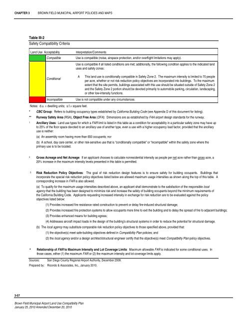
CHAPTER 3BROWN FIELD MUNICIPAL AIRPORT POLICIES AND MAPSTable III-2Safety <strong>Compatibility</strong> Criteria<strong>Land</strong> <strong>Use</strong> AcceptabilityCompatibleInterpretation/Comments<strong>Use</strong> is compatible (noise, airspace protection, and/or overflight limitations may apply).<strong>Use</strong> is compatible if all listed conditions are met; additionally, the following condition applies to the indicated landuses and safety zones:ConditionalIncompatibleAThis land use is conditionally compatible in Safety Zone 2. The maximum intensity is limited to 70 peopleper acre, whether or not risk reduction policy objectives are incorporated into buildings. To the maximumextent that the site permits, buildings associated with this use should be situated outside of Safety Zone 2and the Safety Zone 2 portion should be devoted primarily to automobile parking, circulation, landscaping,or other low-intensity functions.<strong>Use</strong> is not compatible under any circumstances.Notes: d.u. = dwelling units; s.f.= square feet.* CBC Group: Refers to building occupancy types established by California Building Code (see Appendix D of this document for listing).** Runway Safety Area (RSA), Object Free Area (OFA): Dimensions are as established by FAA airport design standards for the runway.1 Ancillary <strong>Use</strong>s: <strong>Land</strong> use types for which a FAR limit is listed in this table as a condition for acceptability in a particular safety zone may have upto 25% of the floor space devoted to an ancillary use of another type, even a use with a higher occupancy load factor, provided that the ancillaryuse is neither:(a) An assembly room having more than 650 occupants; nor(b) A school, day care center, or other risk-sensitive use that is “conditionally compatible” or “incompatible” within the safety zone where theprimary use is to be located.2 Gross Acreage and Net Acreage: If an applicant chooses to calculate nonresidential intensity as people per net acre rather than gross acre, a20% increase in the maximum intensity levels presented in this table is permitted.3Risk Reduction Policy Objectives: The goal of risk reduction design features is to ensure safety for building occupants. Buildings thatincorporate the special risk reduction policy objectives listed below are allowed maximum usage intensities as shown along the top of this table. Acorresponding increase in FAR is also allowed.(a) To qualify for the maximum usage intensities described above, an applicant shall demonstrate to the satisfaction of the responsible localagency that the building has been designed to minimize risk and increase the safety of building occupants beyond the minimum requirements ofthe California Building Code. Applicants requesting increased intensity in exchange for risk reduction are to be evaluated against the policyobjectives listed below:(1) Provides increased fire resistance rated construction to prevent or delay fire-induced structural damage;(2) Provides increased fire protection systems to allow occupants more time to exit the building and to delay the spread of fire to adjacent buildings;(3) Provides enhanced means for building egress;(4) Addresses aircraft impact loads in the design of the building’s structural systems in order to reduce the potential for structural damage.(b) The local agency may substitute comparable risk reduction policy objectives to those specified above, provided that:(1) the objective(s) meet safe-building objectives defined in <strong>Compatibility</strong> <strong>Plan</strong> policies; and(2) the local agency and/or a design architect/structural engineer certify that the objective(s) meet <strong>Compatibility</strong> <strong>Plan</strong> policy objectives.4Relationship of FAR to Maximum Intensity and Lot Coverage Limits: Maximum allowable FAR is indicated for some conditional uses. Inthose cases, either (1) the maximum FAR or (2) the maximum intensity and lot coverage limits apply.Sources: San Diego County Regional <strong>Airport</strong> Authority, December 2009.Prepared by: Ricondo & Associates, Inc., January 2010.3-57<strong>Brown</strong> <strong>Field</strong> <strong>Municipal</strong> <strong>Airport</strong> <strong>Land</strong> <strong>Use</strong> <strong>Compatibility</strong> <strong>Plan</strong>January 25, 2010 Amended December 20, 2010