Okavango Delta Management Plan - Ramsar Convention on Wetlands
Okavango Delta Management Plan - Ramsar Convention on Wetlands
Okavango Delta Management Plan - Ramsar Convention on Wetlands

You also want an ePaper? Increase the reach of your titles
YUMPU automatically turns print PDFs into web optimized ePapers that Google loves.
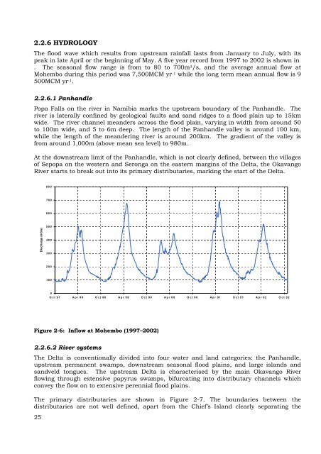
2.2.6 HYDROLOGY<br />
The flood wave which results from upstream rainfall lasts from January to July, with its<br />
peak in late April or the beginning of May. A five year record from 1997 to 2002 is shown in<br />
. The seas<strong>on</strong>al flow range is from to 80 to 700m 3/s, and the average annual flow at<br />
Mohembo during this period was 7,500MCM yr -1 while the l<strong>on</strong>g term mean annual flow is 9<br />
500MCM yr -1.<br />
2.2.6.1 Panhandle<br />
Popa Falls <strong>on</strong> the river in Namibia marks the upstream boundary of the Panhandle. The<br />
river is laterally c<strong>on</strong>fined by geological faults and sand ridges to a flood plain up to 15km<br />
wide. The river channel meanders across the flood plain, varying in width from around 50<br />
to 100m wide, and 5 to 6m deep. The length of the Panhandle valley is around 100 km,<br />
while the length of the meandering river is around 200km. The gradient of the valley is<br />
from around 1,000m (above mean sea level) to 980m.<br />
At the downstream limit of the Panhandle, which is not clearly defined, between the villages<br />
of Sepopa <strong>on</strong> the western and Ser<strong>on</strong>ga <strong>on</strong> the eastern margins of the <str<strong>on</strong>g>Delta</str<strong>on</strong>g>, the <str<strong>on</strong>g>Okavango</str<strong>on</strong>g><br />
River starts to break out into its primary distributaries, marking the start of the <str<strong>on</strong>g>Delta</str<strong>on</strong>g>.<br />
Discharge (m3/s)<br />
Figure 2-6: Inflow at Mohembo (1997–2002)<br />
2.2.6.2 River systems<br />
The <str<strong>on</strong>g>Delta</str<strong>on</strong>g> is c<strong>on</strong>venti<strong>on</strong>ally divided into four water and land categories: the Panhandle,<br />
upstream permanent swamps, downstream seas<strong>on</strong>al flood plains, and large islands and<br />
sandveld t<strong>on</strong>gues. The upstream <str<strong>on</strong>g>Delta</str<strong>on</strong>g> is characterised by the main <str<strong>on</strong>g>Okavango</str<strong>on</strong>g> River<br />
flowing through extensive papyrus swamps, bifurcating into distributary channels which<br />
c<strong>on</strong>vey the flow <strong>on</strong> to extensive perennial flood plains.<br />
The primary distributaries are shown in Figure 2-7. The boundaries between the<br />
distributaries are not well defined, apart from the Chief’s Island clearly separating the<br />
25<br />
800<br />
700<br />
600<br />
500<br />
400<br />
300<br />
200<br />
100<br />
0<br />
Oct 97 Apr 98 Oct 98 Apr 99 Oct 99 Apr 00 Oct 00 Apr 01 Oct 01 Apr 02 Oct 02