Okavango Delta Management Plan - Ramsar Convention on Wetlands
Okavango Delta Management Plan - Ramsar Convention on Wetlands
Okavango Delta Management Plan - Ramsar Convention on Wetlands

You also want an ePaper? Increase the reach of your titles
YUMPU automatically turns print PDFs into web optimized ePapers that Google loves.
Of the three main distributaries, the Thaoge River in the west terminates in a series of<br />
lago<strong>on</strong>s and permanently inundated plains near its upstream end, choked by<br />
sedimentati<strong>on</strong> and vegetati<strong>on</strong>. The Jao/Boro comprises pemanent swamp in its upstream<br />
end. The middle part (essentially the Boro and Kunyere/Xudum/Matsibe) is a system of<br />
seas<strong>on</strong>ally inundated floodplains. In the downstream end it is flowing in c<strong>on</strong>fined channels,<br />
discharging to the Thamalakane and to Lake Ngami. The Maunachira and Khwai, as well as<br />
the Santantadibe in the east, have permanently inundated plains al<strong>on</strong>g the entire length,<br />
with <strong>on</strong>ly narrow bands of seas<strong>on</strong>al floodplains. The Gomoti floods <strong>on</strong>ly in higher rainfall<br />
years. The Khwai, Santantadibe and Gomoti end in single channels. The two latter <strong>on</strong>es<br />
used to c<strong>on</strong>nect to the Thamalakane, which, however, has not been observed since 1989.<br />
The Khwai usually dries out within its channel, but in the past it was probably a major<br />
provider of water to the Mababe depressi<strong>on</strong>; travellers around 1850 described the<br />
depressi<strong>on</strong> as a lake.<br />
2.2.6.3 Outflow<br />
The course of the Thamalakane River follows the Thamalakane Fault line which runs<br />
perpendicular to the main axis of the <str<strong>on</strong>g>Delta</str<strong>on</strong>g> and demarcates its downstream limit. The river<br />
flows south west, and functi<strong>on</strong>s as a collecti<strong>on</strong> drain for the distributaries from upstream.<br />
In low flood years, however, flow in the distributaries succumbs to evaporati<strong>on</strong> and<br />
infiltrati<strong>on</strong> before reaching the Thamalakane River.<br />
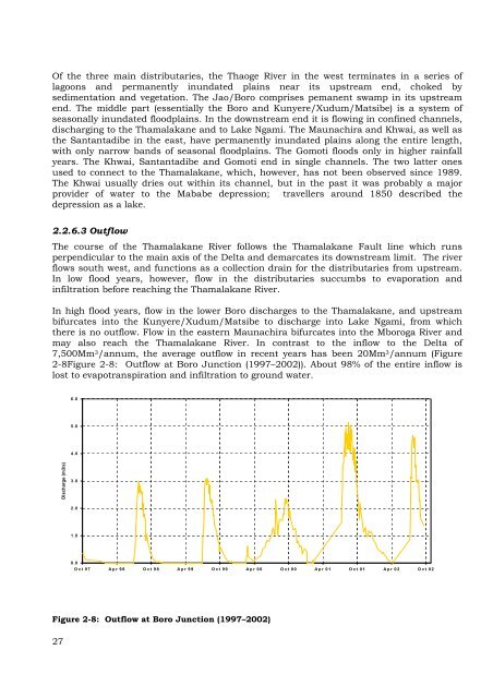
In high flood years, flow in the lower Boro discharges to the Thamalakane, and upstream<br />
bifurcates into the Kunyere/Xudum/Matsibe to discharge into Lake Ngami, from which<br />
there is no outflow. Flow in the eastern Maunachira bifurcates into the Mboroga River and<br />
may also reach the Thamalakane River. In c<strong>on</strong>trast to the inflow to the <str<strong>on</strong>g>Delta</str<strong>on</strong>g> of<br />
7,500Mm 3/annum, the average outflow in recent years has been 20Mm 3/annum (Figure<br />
2-8Figure 2-8: Outflow at Boro Juncti<strong>on</strong> (1997–2002)). About 98% of the entire inflow is<br />
lost to evapotranspirati<strong>on</strong> and infiltrati<strong>on</strong> to ground water.<br />
Discharge (m3/s)<br />
Figure 2-8: Outflow at Boro Juncti<strong>on</strong> (1997–2002)<br />
27<br />
6.0<br />
5.0<br />
4.0<br />
3.0<br />
2.0<br />
1.0<br />
0.0<br />
Oct 97 Apr 98 Oct 98 Apr 99 Oct 99 Apr 00 Oct 00 Apr 01 Oct 01 Apr 02 Oct 02