table of contents - Research and Innovative Technology ...
table of contents - Research and Innovative Technology ...
table of contents - Research and Innovative Technology ...

You also want an ePaper? Increase the reach of your titles
YUMPU automatically turns print PDFs into web optimized ePapers that Google loves.
measure with data, <strong>and</strong> use models for conditions<br />
that cannot be measured directly or that need to<br />
be forecast. The ability to produce credible <strong>and</strong><br />
timely answers to a question varies significantly<br />
by topic, mode, <strong>and</strong> geographic detail.<br />
� Extent <strong>and</strong> Use <strong>of</strong> the<br />
Transportation System<br />
Prior to passage <strong>of</strong> the Intermodal Surface<br />
Transportation Efficiency Act (ISTEA) <strong>of</strong> 1991,<br />
the national picture <strong>of</strong> the transportation system<br />
was limited to very coarse, mode-specific maps<br />
<strong>of</strong> facilities <strong>and</strong> estimates <strong>of</strong> total vehicle activity<br />
by type <strong>of</strong> vehicle. An integrated, geographically<br />
detailed picture <strong>of</strong> transportation facilities<br />
<strong>and</strong> activity across all modes had not been compiled<br />
since the mid-1970s.<br />
Since 1991, BTS has compiled a fairly extensive<br />
picture <strong>of</strong> the components <strong>of</strong> the transportation<br />
system <strong>and</strong> where they are located. The<br />
transportation community is just now beginning<br />
to underst<strong>and</strong> how <strong>and</strong> where the transportation<br />
system is used. The state <strong>of</strong> this knowledge can<br />
be divided into four basic layers <strong>of</strong> information:<br />
facilities, services, flows, <strong>and</strong> context.<br />
� Facilities data include the location, connectivity,<br />
<strong>and</strong> use <strong>of</strong> highways, railroads, airports<br />
<strong>and</strong> air space, ports <strong>and</strong> waterways, <strong>and</strong><br />
pipelines. Good data are available on the<br />
location <strong>and</strong> connectivity for about 10 percent<br />
<strong>of</strong> the nation’s highways, covering the<br />
Interstates <strong>and</strong> other major roads, most railroads,<br />
all rail transit facilities, all public use<br />
airports, <strong>and</strong> ports <strong>and</strong> all navigable waterways.<br />
Facility-specific use data are available<br />
for railroads, ports <strong>and</strong> waterways, airports,<br />
<strong>and</strong> a sample <strong>of</strong> highways. Data on the use <strong>of</strong><br />
specific railroad segments can be estimated.<br />
The location <strong>of</strong> truck <strong>and</strong> rail terminals are<br />
known, primarily for those identified by<br />
states when defining intermodal connector<br />
roads to the National Highway System, but<br />
Chapter 5 The State <strong>of</strong> Transportation Statistics � 109<br />
little is known about the use <strong>of</strong> those facilities.<br />
There is only very coarse information<br />
about the location, connectivity, <strong>and</strong> use <strong>of</strong><br />
pipelines.<br />
� Services data include the geographic domains<br />
<strong>of</strong> carriers <strong>and</strong> the amount <strong>and</strong> type <strong>of</strong> service<br />
provided within those domains. Data on<br />
where commercial airlines <strong>and</strong> long-distance<br />
water carriers operate <strong>and</strong> what service they<br />
provide are available. The ownership <strong>and</strong><br />
trackage rights <strong>of</strong> railroads for each part <strong>of</strong><br />
the rail network are known, but relatively little<br />
is known about the levels <strong>of</strong> service provided<br />
on each segment. The Department <strong>of</strong><br />
Transportation is just now beginning to plot<br />
the location <strong>of</strong> public transit <strong>and</strong> intercity bus<br />
service. Geographic knowledge <strong>of</strong> truck <strong>and</strong><br />
intercity bus operations is very limited, <strong>and</strong><br />
pipeline data are available at best for multistate<br />
regions.<br />
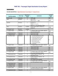
� Flows data include freight, passenger, <strong>and</strong><br />
vehicle movements. The CFS covers most<br />
domestic freight activity, but must be supplemented<br />
by additional information on international,<br />
farm, <strong>and</strong> government shipments to<br />
obtain a complete picture. The surface transborder<br />
part <strong>of</strong> information on international<br />
movements is provided by BTS through the<br />
Census <strong>and</strong> Customs Bureaus. The ATS will<br />
provide information on long-distance passenger<br />
flows <strong>of</strong> U.S. households, but will also<br />
require supplements to identify the domestic<br />
travel <strong>of</strong> foreign visitors. Commercial aircraft<br />
<strong>and</strong> ship movements are tracked in great<br />
detail, but very little is known about the<br />
origin-destination patterns <strong>of</strong> motor vehicles.<br />
� Context data establish the geographic context<br />
in which transportation exists including:<br />
political boundaries <strong>and</strong> other major features<br />
that help to physically locate transportation;<br />
the distribution <strong>of</strong> population <strong>and</strong> economic<br />
activity that generate transportation activity;<br />
<strong>and</strong> the distribution <strong>of</strong> environmental conditions<br />
<strong>and</strong> human activity affected by trans-