- Page 3:
The United States Army inOperation
- Page 6 and 7:
The Library of Congress Cataloging-
- Page 9 and 10:
PrefaceOn Point is a study of Opera
- Page 11 and 12:
AcknowledgementsHistorians prefer t
- Page 13 and 14:
called him unkind names and questio
- Page 15 and 16:
Table of ContentsForeword..........
- Page 19 and 20:
Figure 78. 101st Airborne Division
- Page 21 and 22:
Figure 147. 101st Airborne Division
- Page 23 and 24:
Table of Call Out BoxesThe SIPRNET
- Page 25:
The 8 April Counterattack .........
- Page 29 and 30:
Saddam Hussein and the Ba’athists
- Page 31 and 32:
Army special operations soldiers, a
- Page 34 and 35:
• Information and Knowledge. The
- Page 36 and 37:
successful battles and engagements
- Page 38 and 39:
timelines at the beginning of each
- Page 41 and 42:
Chapter 1Operation DESERT STORM to
- Page 43 and 44:
combat. The US Army’s AirLand Bat
- Page 45 and 46:
The domestic political landscape in
- Page 47 and 48:
was to experiment to anticipate cha
- Page 49 and 50:
The authors also attempted to accou
- Page 51 and 52:
The SIPRNET RevolutionIn addition t
- Page 53 and 54:
efore World War I. 16 The extended
- Page 55 and 56:
commanders to consider the battlesp
- Page 57 and 58:
presence is not possible. Moreover,
- Page 59 and 60:
• The Air Force’s C-17 Globemas
- Page 61 and 62:
GAO Report. Military Transformation
- Page 63 and 64:
On 20 September 2001, President Geo
- Page 65 and 66:
All of these efforts led to a sweep
- Page 67 and 68:
NOTES1. General Frederick M. Franks
- Page 69 and 70:
Chapter 2Prepare, Mobilize, and Dep
- Page 71 and 72:
joint organizations played central
- Page 73 and 74:
Figure 10. Key coalition camps and
- Page 75 and 76:
CLCC LOG and Title 10 PowerPoint pr
- Page 77:
Figure 17. Tern delivers Army water
- Page 80 and 81:
Pre-positioned EquipmentIn Europe d
- Page 82 and 83:
allies in the region in providing s
- Page 84 and 85:
organization to leverage joint inte
- Page 86 and 87:
surprise but allowed a gradual buil
- Page 88 and 89:
Figure 24. V Corps objectivesin any
- Page 90 and 91:
that supported them, while denying
- Page 92 and 93:
Webster and Spider Marks. Marine Br
- Page 94 and 95:
V Corps Command Brief, 15 July 2003
- Page 96 and 97:
V Corps Command Brief, 15 July 2003
- Page 98 and 99:
completing its work in February. BC
- Page 100 and 101:
Figure 32. Soldiers posing with a D
- Page 102 and 103:
Figure 33. V Corps assault command
- Page 104 and 105:
ight thing to do. More than 6,200 s
- Page 106 and 107:
defense coordinator (TAAMCOORD), an
- Page 108 and 109:
attalion leadership, with the USARE
- Page 110 and 111:
The 18th MP Brigade, stationed in M
- Page 112 and 113: and environment of Iraq. They condu
- Page 114 and 115: proper mix of combat, CS, and CSS u
- Page 116 and 117: Given all that can go wrong, the pe
- Page 118 and 119: Jeremiah Johnson, Combat CameraFigu
- Page 120 and 121: opportunities such as a sudden coll
- Page 122 and 123: 27. Major General Robert Blackman,
- Page 124 and 125: 80. Lieutenant Colonel John Huey, p
- Page 126 and 127: Summary of EventsSaddam Hussein and
- Page 128 and 129: • Breaching the berm at the borde
- Page 130 and 131: humanitarian assistance supplies, w
- Page 132 and 133: Intelligence Supporting Operational
- Page 134 and 135: Moving the start of the ground camp
- Page 136 and 137: Figure 42. PSYOP leaflets distribut
- Page 138 and 139: Igor Paustovski, Combat CameraFigur
- Page 140 and 141: Figure 45. Comparison of Iraqi grou
- Page 142 and 143: to secure the first two primary obj
- Page 144 and 145: Crossing The BermThey are coming to
- Page 146 and 147: Figure 50. 3rd ID border breach sch
- Page 148 and 149: covering forces rapidly and simulta
- Page 150 and 151: After the aborted mission, morale s
- Page 152 and 153: act of passing the change of route
- Page 154 and 155: Figure 54. RRP EXXON and FARP SHELL
- Page 156 and 157: Air Base (An Nasiriyah), seize the
- Page 158 and 159: Figure 58. The 3rd BCT scheme of ma
- Page 160 and 161: also captured more than 200 EPWs, i
- Page 164 and 165: Figure 63. Distance from Objective
- Page 166 and 167: Figure 67. Routes of march north to
- Page 168 and 169: Staff Sergeant Dillard Johnson, 1st
- Page 170 and 171: did not see me and began to fire on
- Page 173 and 174: At 1430 on 23 March, 3rd BCT took c
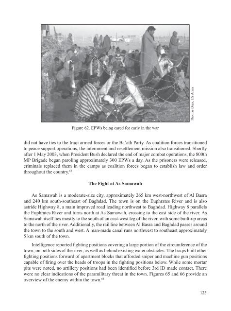
- Page 175: During the fighting at As Samawah,
- Page 178 and 179: 24. Chief Warrant Officer 2 Jay Deh
- Page 180: FLOYD, Johnson’s platoon fought y
- Page 183 and 184: Army Spec. Joshua Earl,a military p
- Page 185: April 1, 2003, black smoke rises fr
- Page 193: US Army photoSgt. 1st Class Anothon
- Page 197 and 198: Chapter 4The March Up-CountryI don
- Page 199 and 200: Figure 74. March up-country sequenc
- Page 201 and 202: working in the LSA and units moving
- Page 203 and 204: Colonel Melvin Frazier, who command
- Page 205 and 206: 101st Abn Div AARFigure 78. 101st A
- Page 207 and 208: Courtesy of V CorpsFigure 80. 3rd I
- Page 209 and 210: All of the estimates accurately ass
- Page 211 and 212: decided to break his convoy into tw
- Page 213 and 214:
Figure 86. The 507th route of movem
- Page 215 and 216:
Figure 87. The 507th Maintenance Co
- Page 217 and 218:
With 3rd BCT, 3rd ID securing the l
- Page 219 and 220:
However, employing LRS is not a Lon
- Page 221 and 222:
the attack on Baghdad. Practically
- Page 223 and 224:
Marcone and Grimsley justifiably ex
- Page 225 and 226:
Figure 92. Ambush Alley—officiall
- Page 227 and 228:
advantage in fighting in the dark.
- Page 229 and 230:
Robert Woodward, US ArmyFigure 93.
- Page 231 and 232:
Figure 95. Chemical soldiers from t
- Page 233 and 234:
all of them. From a broader perspec
- Page 235 and 236:
While never perfect, the Army and e
- Page 237 and 238:
Figure 96. 11th AHR attack scheme f
- Page 239 and 240:
Still, the regiment planned routes
- Page 241 and 242:
Moreover, with less than half of th
- Page 243 and 244:
Figure 99. Apache attack helicopter
- Page 245 and 246:
her husband had been shot and was i
- Page 247 and 248:
AdaptationsFollowing the attack, Ar
- Page 249 and 250:
PlanningThe planned 101st attack ag
- Page 251 and 252:
The 2-101st intended to attack the
- Page 253 and 254:
Figure 104. 101st Airborne Division
- Page 255 and 256:
Figure 107. 3rd ID’s scheme to en
- Page 257 and 258:
followed. The third tank, Lieutenan
- Page 259 and 260:
the division elected to block the e
- Page 261 and 262:
3-73-7CAVCAVFightingFightingininAnA
- Page 263 and 264:
Figure 112. Relief in place of 3-7
- Page 265 and 266:
enemy as they had at As Samawah. Ar
- Page 267 and 268:
Figure 114. Lieutenant General Wall
- Page 269 and 270:
airborne assault, the units had beg
- Page 271 and 272:
From 29-30 March, the 82nd conducte
- Page 273 and 274:
Figure 118. 101st Airborne Division
- Page 275 and 276:
Company at Checkpoint Charlie, subo
- Page 277 and 278:
towns during the five simultaneous
- Page 279 and 280:
Figure 124. PSYOP leaflets to minim
- Page 281 and 282:
The 173rd’s combat capability als
- Page 283 and 284:
moment. The ground had been plowed
- Page 285 and 286:
The brigade also jumped with a high
- Page 287 and 288:
Figure 129. TF 1-63 AR Abrams tank
- Page 289 and 290:
NOTES1. Captain Michael Matthews, O
- Page 291 and 292:
59. Colonel Rodney Mallette, MTMC,
- Page 293 and 294:
133. Oliver.134. Marcone.135. Ibid.
- Page 295:
202. Colonel Blair Ross, A Transfor
- Page 298 and 299:
to Baghdad in the east, and the I M
- Page 300 and 301:
Figure 133. Objectives in the vicin
- Page 302 and 303:
crossed a river or entered the maze
- Page 304 and 305:
three brigade combat teams, 1st BCT
- Page 306 and 307:
paid off in spades. ThroughoutI’v
- Page 308 and 309:
Figure 135. Enemy disposition in th
- Page 310 and 311:
ack toward Baghdad, and began condu
- Page 312 and 313:
Figure 140. Sample district council
- Page 314 and 315:
virtually every type of mission pos
- Page 316 and 317:
Lieutenant General Wallace on theFi
- Page 318 and 319:
Figure 144. Objective MURRAYabout I
- Page 320 and 321:
Figure 145. Enemy and friendly disp
- Page 322 and 323:
The Approach: Isolating An NajafAft
- Page 324 and 325:
Figure 147. 101st Airborne Division
- Page 326 and 327:
130th Engineer BrigadeFigure 149. E
- Page 328 and 329:
When his battalion attacked into to
- Page 330 and 331:
The FeintAt 0600, the Thunderbolts
- Page 332 and 333:
on the way to Al Hillah. Accordingl
- Page 334 and 335:
that the adversary seldom behaves a
- Page 336 and 337:
learned from the 3rd ID, SOF troops
- Page 338 and 339:
The protracted fighting in As Samaw
- Page 340 and 341:
Figure 156. The scheme for the isol
- Page 342 and 343:
Launching the AttackHaving rearmed
- Page 344 and 345:
IN and the tactical command post—
- Page 346 and 347:
Electronic attacks against enemy co
- Page 348 and 349:
Figure 164. TF 3-69 AR attacks to s
- Page 350 and 351:
The Smoke Mission at Objective PEAC
- Page 352 and 353:
Figure 166. 2nd BCT attacks to Obje
- Page 354 and 355:
Figure 168. Iraqi tank burning in t
- Page 356 and 357:
Accelerating the AttackDuring this
- Page 358 and 359:
The ApproachTrue to his word, Grims
- Page 360 and 361:
V CorpsFigure 171. Civilian aircraf
- Page 362 and 363:
First Lieutenant Mark Schenck, writ
- Page 364 and 365:
Essayons: Sergeant First Class Paul
- Page 366 and 367:
to one of the road craters at appro
- Page 368 and 369:
Figure 177. Platoon leaders of Apac
- Page 370 and 371:
Figure 179. The 3rd BCT Objectives
- Page 372 and 373:
TF 2-69 Armor, the brigade’s main
- Page 374 and 375:
Sanderson led from the front near t
- Page 376 and 377:
caught fire and ammunition began to
- Page 379 and 380:
NOTES1. Anthony H. Cordesman, The I
- Page 381 and 382:
61. Ibid. 2-70 AR; and Lieutenant C
- Page 383 and 384:
131. 2nd BCT, 3rd ID, 3. See also L
- Page 385 and 386:
Chapter 6Regime Collapse“There ar
- Page 387 and 388:
Figure 184. Attack to BaghdadBaghda
- Page 389 and 390:
Actions ElsewhereAs the corps’ an
- Page 391 and 392:
While some soldiers worked to help
- Page 393 and 394:
[of Saddam Hussein] were located. T
- Page 395 and 396:
These soldiers collect and process
- Page 397 and 398:
As the situation developed during t
- Page 399 and 400:
Despite the relative ease of their
- Page 401 and 402:
Mason Lowery, US ArmyFigure 190. TF
- Page 403 and 404:
Thunder Run of 7 AprilTask: Attack
- Page 405 and 406:
warrant. 40 If conditions wereGoing
- Page 407 and 408:
they came upon them, passing them o
- Page 409 and 410:
Figure 195. TF 1-64 AR movement int
- Page 411 and 412:
Figure 197. The 2nd BCT disposition
- Page 413 and 414:
dazed. The explosion and fires prod
- Page 415 and 416:
Specialist Gates took it it and ran
- Page 417 and 418:
Task OrganizationOn the evening bef
- Page 419 and 420:
LARRY, and Gator would secure the n
- Page 421 and 422:
The Pros from Dover—Special Force
- Page 423 and 424:
About the same time as Johnson move
- Page 425 and 426:
Rage faced dismounted Republican Gu
- Page 427 and 428:
Firing on all Cylinders— —Engin
- Page 429 and 430:
Figure 206. The Iraqi counterattack
- Page 431 and 432:
Figure 207. The Iraqi counterattack
- Page 433 and 434:
Silver Star RecommendationSpecialis
- Page 435 and 436:
NOTES1. Anthony H. Cordesman, The I
- Page 437 and 438:
Post). This information comes from
- Page 439 and 440:
Chapter 7ImplicationsSoldiers, sail
- Page 441 and 442:
OIF demonstrated that the COE is no
- Page 443 and 444:
from the War in Iraq.” The Russia
- Page 445 and 446:
Bank and Gaza provided grist for Ar
- Page 447 and 448:
Although urban operations in OIF pr
- Page 449 and 450:
Fort Irwin “replicated” the ene
- Page 451 and 452:
level did have satellite communicat
- Page 453 and 454:
The evidence of OIF does not compel
- Page 455 and 456:
Of course, building a doctrine and
- Page 457 and 458:
also find ways to achieve interdepe
- Page 459 and 460:
Special Forces in ActionOn 20 20 Ap
- Page 461 and 462:
Liaison between Army special forces
- Page 463 and 464:
Simply stated, operational maneuver
- Page 465 and 466:
petroleum, oil, and lubricants (POL
- Page 467 and 468:
Logistics SuccessesThere are some g
- Page 469 and 470:
Following the incident, the Army la
- Page 471 and 472:
Grouping so many capabilities in th
- Page 473 and 474:
The efficacy of net-enabled means t
- Page 475 and 476:
Information OperationsOperation OIF
- Page 477 and 478:
There are some obvious OIF implicat
- Page 479 and 480:
Most tactical unit commanders claim
- Page 481 and 482:
NOTES1. JFCOM and TRADOC are moving
- Page 483 and 484:
Chapter 8TransitionPeace enforcemen
- Page 485 and 486:
On Point has not been able to deliv
- Page 487 and 488:
I Guess I Made an ImpressionThis fi
- Page 489 and 490:
him the opportunity to honor his cl
- Page 491:
NOTES1. General Peter J. Schoomaker
- Page 494 and 495:
DESERT STORM as commander of VII Co
- Page 497 and 498:
Combined Forces Land Component Comm
- Page 499 and 500:
Facilities Engineer Team410th Milit
- Page 501 and 502:
244th Theater Aviation Brigade (OPC
- Page 503 and 504:
Facilities Engineer Detachment BFor
- Page 505 and 506:
Detachment/Marine Light Attack Heli
- Page 507 and 508:
Detachment/Marine Aerial Refueler/T
- Page 509 and 510:
4th Light Armored Recon Battalion (
- Page 511 and 512:
10th Logistics Planning Augmentatio
- Page 513 and 514:
315th Tactical PSYOP CoTactical PSY
- Page 515 and 516:
Shadow Tactical Unmanned Aerial Veh
- Page 517 and 518:
1st Brigade, 4th Infantry DivisionH
- Page 519 and 520:
Tactical PSYOP Team 221/362nd Tacti
- Page 521 and 522:
Control Ground Station Team 5/5/D/3
- Page 523 and 524:
Ground Surveillance Systems Platoon
- Page 525 and 526:
Eagle-Intel/Analysis and Control El
- Page 527 and 528:
A/326th Engineer BattalionTeam 1/27
- Page 529 and 530:
Elements/4th Air Support Operations
- Page 531 and 532:
864th Engineer Battalion (-) (Comba
- Page 533 and 534:
HHC (-)/22nd Signal Bde17th Signal
- Page 535 and 536:
51st Movement Control Detachment (D
- Page 537 and 538:
HHC/418th Quartermaster Bn59th Quar
- Page 539 and 540:
507th Medical Co (Air Ambulance) (A
- Page 541 and 542:
AMC Logistics Support Element FWD -
- Page 543 and 544:
381st Military Police Detachment (E
- Page 545 and 546:
513th Transportation Co (Medium Tru
- Page 547 and 548:
249th Quartermaster Co (Repair Part
- Page 549 and 550:
946th Transportation Co (Medium Tru
- Page 551 and 552:
Marine Medium Helicopter Squadron 2
- Page 553 and 554:
Glossary A2C2AAAAAMDCAASLTABC-BLABC
- Page 555 and 556:
C1C2C2C2XC2PCC3C4C4ISRC5C6CACACOMCA
- Page 557 and 558:
EUCOMEXORDF/AFAFAIOFARPFBCB2FIFFIST
- Page 559 and 560:
JLOTSJOEJOPESJRACJRTCJSOTFJSOTF-NOR
- Page 561 and 562:
OBJODAODSOEFOHOIFOIF-SGO/OOOTWOPCON
- Page 563 and 564:
SOCCESOCCENTSOCOMSOFSOPSPSPACECOMSP
- Page 565 and 566:
BibliographyInterviews, Discussions
- Page 567 and 568:
Group InterviewsInterview with CFLC
- Page 569 and 570:
Dilanian, Ken. “Airborne Jumps In
- Page 571 and 572:
Joint Publication 4-01.8. Joint Tac
- Page 573 and 574:
• 335th Theater Signal Command•
- Page 575:
Lieutenant Colonel David Kolleda.
- Page 578 and 579:
103 Military Intelligence Battalion
- Page 580 and 581:
603rd Aviation Support Battalion ·
- Page 582 and 583:
General, USMC, Chief of Staff, CFLC
- Page 584 and 585:
Davis, Wilbur, Staff Sergeant, USA,
- Page 586 and 587:
Operations Officer, National Ground
- Page 588 and 589:
219, 223, 243, 278, 296, 314, 331,
- Page 590 and 591:
198, 284, 315Objective RAMS · 102,
- Page 592 and 593:
427, 430, 518Schwartz, Eric ‘Rick
- Page 594 and 595:
USS Higgins, Aegis Destroyer · 65,
- Page 598:
The United Strates Army in Opera