

airport/documents/Mesquite Master Plan Final.pdf - The City of ...
airport/documents/Mesquite Master Plan Final.pdf - The City of ...
airport/documents/Mesquite Master Plan Final.pdf - The City of ...

You also want an ePaper? Increase the reach of your titles
YUMPU automatically turns print PDFs into web optimized ePapers that Google loves.
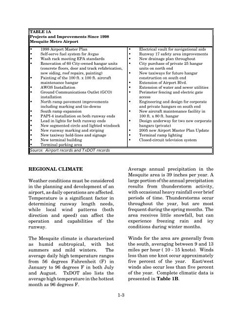
TABLE 1A<br />
Projects and Improvements Since 1998<br />
<strong>Mesquite</strong> Metro Airport<br />
• 1998 Airport <strong>Master</strong> <strong>Plan</strong><br />
• Self-serve fuel system for Avgas<br />
• Wash rack meeting EPA standards<br />
• Renovation <strong>of</strong> 60 <strong>City</strong>-owned hangar units<br />
(concrete floors, door and track refabrication,<br />
new siding, ro<strong>of</strong> repairs, painting)<br />
• Painting <strong>of</strong> the 100 ft. x 100 ft. aircraft<br />
maintenance hangar<br />
• AWOS Installation<br />
• Ground Communications Outlet (GCO)<br />
installation<br />
• North ramp pavement improvements<br />
including marking and tie-downs<br />
• South ramp expansion<br />
• PAPI-4 installation on both runway ends<br />
• Lead in lights for both runway ends<br />
• New segmented circle and lighted windsock<br />
• New runway marking and striping<br />
• New taxiway hold-lines and signage<br />
• New terminal building<br />
• Terminal parking area<br />
Source: Airport records and TxDOT records<br />
REGIONAL CLIMATE<br />
Weather conditions must be considered<br />
in the planning and development <strong>of</strong> an<br />
<strong>airport</strong>, as daily operations are affected.<br />
Temperature is a significant factor in<br />
determining runway length needs,<br />
while local wind patterns (both<br />
direction and speed) can affect the<br />
operation and capabilities <strong>of</strong> the<br />
runway.<br />
<strong>The</strong> <strong>Mesquite</strong> climate is characterized<br />
as humid subtropical, with hot<br />
summers and mild winters. <strong>The</strong><br />
average daily high temperature ranges<br />
from 56 degrees Fahrenheit (F) in<br />
January to 96 degrees F in both July<br />
and August. TxDOT also lists the<br />
average high temperature in the hottest<br />
month as 96 degrees F.<br />
1-3<br />
• Electrical vault for navigational aids<br />
• Runway 17 safety area improvements<br />
• New drainage plan throughout<br />
• <strong>City</strong> purchase <strong>of</strong> private 25 hangar<br />
units on north end<br />
• New taxiways for future hangar<br />
construction on south end<br />
• Extension <strong>of</strong> Airport Blvd.<br />
• Extension <strong>of</strong> water and sewer utilities<br />
• Perimeter fencing and electric gate<br />
access<br />
• Engineering and design for corporate<br />
and private hangars on south end<br />
• New aircraft maintenance facility in<br />
100 ft. x 80 ft. hangar<br />
• Design underway for two new corporate<br />
hangars (private)<br />
• 2005 new Airport <strong>Master</strong> <strong>Plan</strong> Update<br />
• Terminal ramp lighting<br />
• Closed-circuit television system<br />
Average annual precipitation in the<br />
<strong>Mesquite</strong> area is 39 inches per year. A<br />
large portion <strong>of</strong> the annual precipitation<br />
results from thunderstorm activity,<br />
with occasional heavy rainfall over brief<br />
periods <strong>of</strong> time. Thunderstorms occur<br />
throughout the year, but are most<br />
frequent during the spring months. <strong>The</strong><br />
area receives little snowfall, but can<br />
experience freezing rain and icy<br />
conditions during winter months.<br />
Winds for the area are generally from<br />
the south, averaging between 9 and 13<br />
miles per hour ( 10 - 15 knots). Winds<br />
less than one knot occur approximately<br />
five percent <strong>of</strong> the year. East/west<br />
winds also occur less than five percent<br />
<strong>of</strong> the year. Complete climatic data is<br />
presented in Table 1B.

