

airport/documents/Mesquite Master Plan Final.pdf - The City of ...
airport/documents/Mesquite Master Plan Final.pdf - The City of ...
airport/documents/Mesquite Master Plan Final.pdf - The City of ...

You also want an ePaper? Increase the reach of your titles
YUMPU automatically turns print PDFs into web optimized ePapers that Google loves.
TOUCH-AND-GO: an operation by an<br />
aircraft that lands and departs on a runway<br />
without stopping or exiting the<br />
runway. A touch-and-go is recorded as<br />
two operations: one operation for the<br />
landing and one operation for the<br />
take<strong>of</strong>f.<br />
TOUCHDOWN ZONE (TDZ): <strong>The</strong> first<br />
3,000 feet <strong>of</strong> the runway beginning at<br />
the threshold.<br />
TOUCHDOWN ZONE ELEVATION<br />
(TDZE): <strong>The</strong> highest elevation in the<br />
touchdown zone.<br />
TOUCHDOWN ZONE (TDZ) LIGHT-<br />
ING: Two rows <strong>of</strong> transverse light bars<br />
located symmetrically about the runway<br />
centerline normally at 100-foot intervals.<br />
<strong>The</strong> basic system extends 3,000 feet<br />
along the runway.<br />
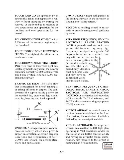
TRAFFIC PATTERN: <strong>The</strong> traffic flow<br />
that is prescribed for aircraft landing at<br />
or taking <strong>of</strong>f from an <strong>airport</strong>. <strong>The</strong> components<br />
<strong>of</strong> a typical traffic pattern are<br />
the upwind leg, crosswind leg, downwind<br />
leg, base leg, and final approach.<br />
BASE<br />
LEG<br />
FINAL APPROACH<br />
RUNWAY<br />
ENTRY<br />
DOWNWIND LEG<br />
UPWIND LEG<br />
CROSS-<br />
WIND<br />
LEG<br />
DEPARTURE LEG<br />
UNICOM: A nongovernment communication<br />
facility which may provide<br />
<strong>airport</strong> information at certain <strong>airport</strong>s.<br />
Locations and frequencies <strong>of</strong> UNI-<br />
COM’s are shown on aeronautical<br />
charts and publications.<br />
A-11<br />
UPWIND LEG: A flight path parallel to<br />
the landing runway in the direction <strong>of</strong><br />
landing. See “traffic pattern.”<br />
VECTOR: A heading issued to an aircraft<br />
to provide navigational guidance<br />
by radar.<br />
VERY HIGH FREQUENCY/ OMNIDI-<br />
RECTIONAL RANGE STATION<br />
(VOR): A ground-based electronic navigation<br />
aid transmitting very high<br />
frequency navigation signals, 360<br />
degrees in azimuth, oriented from<br />
magnetic north. Used as the<br />
basis for navigation in the<br />
national airspace<br />
system. <strong>The</strong> VOR<br />
periodically identifies<br />
itself by Morse Code<br />
and may have an<br />
additional voice<br />
identification feature.<br />
300°<br />
240°<br />
VERY HIGH FREQUENCY OMNI-<br />
DIRECTIONAL RANGE STATION/<br />
TACTICAL AIR NAVIGATION<br />
(VORTAC): A navigation aid providing<br />
VOR azimuth, TACAN azimuth, and<br />
TACAN distance-measuring equipment<br />
(DME) at one site.<br />
VICTOR AIRWAY: A control area or<br />
portion there<strong>of</strong> established in the form<br />
<strong>of</strong> a corridor, the centerline <strong>of</strong> which is<br />
defined by radio navigational aids.<br />
VISUAL APPROACH: An approach<br />
wherein an aircraft on an IFR flight plan,<br />
operating in VFR conditions under the<br />
control <strong>of</strong> an air traffic control facility<br />
and having an air traffic control authorization,<br />
may proceed to the <strong>airport</strong> <strong>of</strong><br />
destination in VFR conditions.<br />
360°<br />
180°<br />
60°<br />
120°<br />
Airport Consultants<br />
www.c<strong>of</strong>fmanassociates.com

