Declaration of Conformity - Nokia
Declaration of Conformity - Nokia
Declaration of Conformity - Nokia

Create successful ePaper yourself
Turn your PDF publications into a flip-book with our unique Google optimized e-Paper software.
Positioning (GPS)<br />
94<br />
● Some vehicles have tinted (athermic) windows,<br />
which may block the satellite signals.<br />
Check satellite signal status<br />
To check how many satellites your device has found,<br />
and whether your device is receiving satellite<br />
signals, press , and select Tools ><br />
Connectivity > GPS data > Position ><br />
Options > Satellite status.<br />
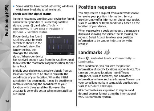
If your device has found<br />
satellites, a bar for each<br />
satellite is shown in the<br />
satellite info view. The<br />
longer the bar, the<br />
stronger the satellite<br />
signal. When your device<br />
has received enough data from the satellite signal<br />
to calculate the coordinates <strong>of</strong> your location, the bar<br />
turns black.<br />
Initially your device must receive signals from at<br />
least four satellites to be able to calculate the<br />
coordinates <strong>of</strong> your location. When the initial<br />
calculation has been made, it may be possible to<br />
continue calculating the coordinates <strong>of</strong> your<br />
location with three satellites. However, the<br />
accuracy is generally better when more satellites<br />
are found.<br />
Position requests<br />
You may receive a request from a network service<br />
to receive your position information. Service<br />
providers may <strong>of</strong>fer information about local topics,<br />
such as weather or traffic conditions, based on the<br />
location <strong>of</strong> your device.<br />
When you receive a position request, a message is<br />
displayed showing the service that is making the<br />
request. Select Accept to allow your position<br />
information to be sent or Reject to deny the<br />
request.<br />
Landmarks<br />
Press , and select Tools > Connectivity ><br />
Landmarks.<br />
With Landmarks, you can save the position<br />
information <strong>of</strong> specific locations in your device. You<br />
can sort the saved locations into different<br />
categories, such as business, and add other<br />
information to them, such as addresses. You can use<br />
your saved landmarks in compatible applications,<br />
such as GPS data and Maps.<br />
GPS coordinates are expressed in degrees and<br />
decimal degrees format using the international<br />
WGS-84 coordinate system.