Smith's Canadian gazetteer - ElectricCanadian.com
Smith's Canadian gazetteer - ElectricCanadian.com
Smith's Canadian gazetteer - ElectricCanadian.com

Create successful ePaper yourself
Turn your PDF publications into a flip-book with our unique Google optimized e-Paper software.
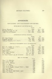
187<br />
TEOUMSKTH.<br />
A Township in the Simcoe District ; is houndi'd on the north by tlie township<br />
of Essa ; on the west by Adjaia ; on the south by Albion and Kinj:; ; and<br />
on the east by Gwillinibury West. In Teciunseth 40,768 aeres are taken up,<br />
11,576 of wliich are under cultivation. The township is well watered by<br />
numerous small streams which unite in the north of the township, forming the<br />
Nottawasaj];a River. A larjje swamp is situated on the town-line between<br />
Tecuinseth and West GwiUinil)ury. wliich borders the Nottawasa;;a River, and<br />
is joined in the north of the township by another swam|), whieli extends into<br />
Adjala. Tecumseth is well settled, and contains many fine farms ; the land is<br />
generally rolling-, and the timber of f>ood (lualiiy. There are in the township<br />
one grist and six saw mills. In Tecumsetli 8,UU0 acres of Crown lauds are open<br />
for sale, at Ss. c'y per acre.<br />
Population in 1842, 2,491, who are principally Scotch, Irish, and Americans.<br />
Ratable property in the township, £27,790.<br />
TEMPERA NCEVILLE.<br />
A Settlement in the township of Malaliide,<br />
on Talbot Street, about ten miles<br />
east from St. Thomas, situatid on Catfish Creek, or River liarbu. It contains<br />
about 100 inliabitants, one store, two taverns, one waggon maker, one tailor,<br />
one blacksmith,<br />
THAMES, RIVER.<br />
One of the principal rivers in Canada West, formerly called La Tranche.<br />
The north, or principal branch, takes its rise in the great swamp, north of the<br />
Huron District; passes through McKillop and Logan, into the north corner of<br />
FuUarton, where it is joined by a branch from Hibbert. Lower down in the<br />
township it is joined by a small bri;ncli; it then passes out of the south <strong>com</strong>er<br />
of FuUarion, cuts across the east corner of Ulanshard into Nissouri, where it is<br />
joined by a branch, called the " Avon." which runs through Easthope and<br />
Zorra. It then tiows into the township of London, where it is joined by a<br />
branch from IJsborn and IJiddulph. At the town of London it is joined by the<br />
east branch, which takes its rise in Easthope forms the dividing line between<br />
Blandford and Zorra, separates \V'esi from North Oxford, North from South<br />
Dorchester, and then flows along the south border of the townshi]) of London,<br />
separating it from Westminster. After joining the north brancli, the united<br />
stream continues its course in a south-westerly direction, forming tlie dividing<br />
boundary between the townships of Lobo, Carradoc, Ekfrid, Mosa, Zone, Camden<br />
West, Chatham and Dover, on the north; and Delaware, Southwold, Dunwieh,<br />
Aklboro, Orford, Howard, Harwich, Raleigh, and East Tilbury, on tlie<br />
soutli; between which last township and Dover, it discharges itself into Lake<br />
St. Clair. It is joined by many small streams in its course, and at Chatham it<br />
is joined by M'Gregor's Ch-eek.<br />
On the upper portions of tiiis river are numerous grist and saw mills.<br />
At and above Delaware, it aii'ords fine trout fishing; and below, during the<br />
spring, (|uantities of white fish, pike, pickerel, and maskelonge are taken, with<br />
occasionally sturgeon. Several hundred barrels offish are frequently cui'ed at<br />
and in the neighbourhood of Chatham.<br />
The Thames is navigable for steamboats and schooners to Louisville, a<br />
village nearly tliirty miles from its month, and might be made navigable to<br />
London, at no very- great expense. To Louisville, it is of an average depth of<br />
16 feet, and in breadth from 200 to 300 feet. The river passes tlirough some<br />
of the fin^'st country in Western Canada; the banks on the upper portion being<br />
high and rolling; while below, for a distance of about thiriy-five n\iles, the land<br />
is mostly level and rich, forming some of the best fainiing laud in the Western<br />
District; and noted for its sujiei-ior growth of wheat. Many of ihe farms ou<br />
this portion of the river, have been settled for fifty years, and are in a high stateof<br />
c-ultivation, with fine orchards.