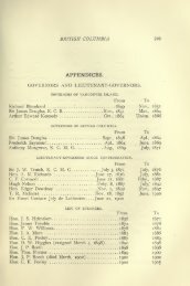
Smith's Canadian gazetteer - ElectricCanadian.com
Smith's Canadian gazetteer - ElectricCanadian.com
Smith's Canadian gazetteer - ElectricCanadian.com

You also want an ePaper? Increase the reach of your titles
YUMPU automatically turns print PDFs into web optimized ePapers that Google loves.
84<br />
10,500 Bushels of Wlieat, valued at £1,968 15<br />
114,000 Pipe Staves " " l.:i82 10<br />
169 Barrels Pork, " " 338<br />
Some seasons, as much as 100 hogsheads of Tobacco have been sliipped from<br />
tha tOT^nship, but latterly, from the diminished dutj' imposed upon tcbacco from<br />
the United States, the crop has be<strong>com</strong>e unprofitable, and the farmers have conseqtently<br />
discontinued the cultivation.<br />
Population in 1845, 1,896.<br />
Ratable property in the township, £22,122.<br />
HULLETT.<br />
A tt)-wnship in the Huron District ; is bounded on the north-east by Crown<br />
lands ; on the west by the towiisliips of Colborne and Goderich ; on the southwest<br />
by Tuckersmith ; and on the south-east by McKillop. A branch of the<br />
Maitland River runs through this township. The soil is generally good. Hullett<br />
contains 35,941 acres, 3,960 of which are leased or sold, of which 324 acres<br />
are undei" cultivation.<br />
Population 195.<br />
Ratable property in the township, £1,470. 4s.<br />
HUMBER RIVER.<br />
Takes its rise in the township of Vaughan, and follows nearly a south course<br />
to Lake Ontario, forming the boundary between the townships of Etobicoke and<br />
York. The village of We.ston is situated on the Humber, in the township of<br />
Etobicoke, aad there are several grist and saw mills on it.<br />
HUMBERSTONE.<br />
A Township in the Niagara District; is bouuded on the east by the township<br />
of Bertie; on the north by Crowland; on the west by Wainfleet; and on the<br />
south by Lake Erie. In Humberstone 20,484 acres are taken up, 0,596 of which<br />
are under cultivation. Humberstone contains good land; but many of the farms<br />
are not well cultivated. There are one grist and two saw mills in the township.<br />
Population in 1841, 1,376; who are principally Pennsylvanian Dutch and<br />
their descendants; with a small mixture of <strong>Canadian</strong>s, Americans and Germans.<br />
Ratable property in the township, £23 7o4.<br />
HUNGERFORD.<br />
A Township in the Victoria District; is bounded on the east by the township<br />
of Sheffield ; on the north by Elzevir ; on the west by Huntingdon ; and on the<br />
south by Tyendenaga and Richmond. In Hungerford 19,472 acres are taken<br />
up, 3,933 of which are under cultivation. A small lake is situated near the<br />
centre of the township, having several small streams running into it. The<br />
Moira River takes its rise in this lake, and leaves the township at its south-west<br />
corner. There are four grist mills and one saw mill in the township. Five<br />
thousand four hundred and fifteen acres of Crown lands are open for sale in<br />
Hungerford, at Ss. currency per acre.<br />
Population in 1842, 880, who are principally protestant Irish.<br />
Ratable property in the township, £10,715.<br />
HUNTINGFORD.<br />
A Settlement in the cast of the township of Zoira: it contains about fifty inhabitants,<br />
an Episcopal cluirch, a tavern, and a Idacksmith's shop.<br />
HUNTINGDON.<br />
\ Township in the Victcrria District ; is bounded on the east by the township<br />
of Hungerford; on the nortli by Madoc; on the west by Raw don ; and on the