- Page 5 and 6:
PREFACEThe Tahoe Regional Planning
- Page 7 and 8:
TABLE OF CONTENTSPREFACE...........
- Page 9:
3.5.5 Stormwater Treatment ........
- Page 12 and 13:
6.3 Projects 1 to 5 Acres and all C
- Page 14 and 15:
8.10.5 Maintenance ................
- Page 16 and 17:
Table 8-4: Federal, State and Regio
- Page 18 and 19:
Figure 4.3-i: Vegetated Swale .....
- Page 20 and 21:
INTRODUCTIONPURPOSE AND USERS OF TH
- Page 22 and 23:
Lake Tahoe’s world renowned blue
- Page 24 and 25:
Urbanization in the Lake Tahoe wate
- Page 26 and 27:
50 percent of the light scattering
- Page 28 and 29:
Figure I-c: Impervious Cover versus
- Page 30 and 31:
Disconnected impervious areasdrain
- Page 32 and 33:
POLLUTANT EFFECT URBAN SOURCES ASSO
- Page 34 and 35:
BEST MANAGEMENT PRACTICESHistorical
- Page 36 and 37: Table I-2: Differences in BMP Retro
- Page 38 and 39: CHAPTER 1: URBAN HYDROLOGY1.1 PURPO
- Page 40 and 41: Figure 1-a: Runoff ProcessesTRPA BM
- Page 42 and 43: Although many urbanized areas face
- Page 44 and 45: watersheds to make the necessary es
- Page 46 and 47: Pollutant load estimates are typica
- Page 48 and 49: differ from the following recommend
- Page 50 and 51: Figure 1-b: Hydrologic Processes an
- Page 52 and 53: 1.3.3.2 NRCS BMP CALCULATION SPREAD
- Page 54 and 55: 1.3.3.3 RATIONAL METHODMODEL SUMMAR
- Page 56 and 57: 1.3.3.4 LOAD REDUCTION PLANNING TOO
- Page 58 and 59: in HMS may be event-based or contin
- Page 60 and 61: 1.3.3.6 POLLUTANT LOAD REDUCTION MO
- Page 62 and 63: AVAILABILITY AND SUPPORTING DOCUMEN
- Page 64 and 65: TYPICAL LEVEL OF EFFORTHSPF and LSP
- Page 66 and 67: few days to a week of time to revie
- Page 68 and 69: USACE studies recommended use of th
- Page 70 and 71: during the initial site visit, or c
- Page 72 and 73: Figure 2-a: Soil Horizons• Depth
- Page 74 and 75: Evidence of compacted and disturbed
- Page 76 and 77: UNMAPPED ROCK OUTCROPS, STEEP SLOPE
- Page 78 and 79: The primary pollutants of concern o
- Page 80 and 81: On the map use an arrow to delineat
- Page 82 and 83: 2.2.3 ADDITIONAL DATA GATHERINGAfte
- Page 84 and 85: and allowable uses. Baseline Land C
- Page 88 and 89: susceptibility to, being erodible (
- Page 91 and 92: SEZ/SEASONAL HIGH GROUNDWATER AREAS
- Page 93 and 94: Board in California and the Nevada
- Page 95 and 96: to be infiltrated. For a small site
- Page 97 and 98: 2.3.2.3 SITE CONSTRAINED PROPERTIES
- Page 99 and 100: to restoration taking place. If it
- Page 101 and 102: • Section 3.9 has considerations
- Page 103 and 104: 3.4.1 STANDARDS AND REGULATIONSIn o
- Page 105 and 106: C. PROTECT NATURAL AREASInstall per
- Page 107 and 108: Table 3-3: Hydrologic Source Contro
- Page 109 and 110: Slotted channel drain collecting dr
- Page 111 and 112: Figure 3-a: BMP Selection Flowchart
- Page 113 and 114: 3.5.1 STANDARDS AND REGULATIONSIn o
- Page 115 and 116: C. DETECT AND REMOVE ILLICIT DISCHA
- Page 117 and 118: not feasible, infiltration basins c
- Page 119 and 120: E. PROTECT STORMWATER DISCHARGE POI
- Page 121 and 122: Table 3-8: Hydrologic Source Contro
- Page 123 and 124: Figure 3-c: Offline SystemA flow sp
- Page 125 and 126: 3.6 PROJECTS GREATER THAN 5 ACRES A
- Page 127 and 128: Lahontan Regional Water Quality Con
- Page 129 and 130: 3.8.2.1 HIGH GROUNDWATER AND BEDROC
- Page 131 and 132: 3.8.2.7 100 PERCENT IMPERVIOUSNESST
- Page 133 and 134: 3.9.4 FOREST SERVICE SUMMER SEASONA
- Page 135 and 136: Certificate of Completion. Project
- Page 137 and 138:
LIST OF FIGURESFigure 4.1-a: Pervio
- Page 139 and 140:
CHAPTER 4: BMP ToolkitTRPA BMP Hand
- Page 141 and 142:
from roads or parking lots that are
- Page 143 and 144:
Turf Blocks:• Open-celled units,
- Page 145 and 146:
Table 4.1-1: Pervious Pavement Insp
- Page 147 and 148:
CHAPTER 4: BMP ToolkitTRPA BMP Hand
- Page 149 and 150:
• Infiltration basins shall not b
- Page 151 and 152:
An infiltration basin functioning d
- Page 153 and 154:
Table 4.1-2: Infiltration Basin Ins
- Page 155 and 156:
Figure 4.1-b: Infiltration BasinCHA
- Page 157 and 158:
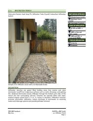
APPLICABILITY• Widely applicable
- Page 159 and 160:
This infiltration trench is too ste
- Page 161 and 162:
Table 4.1-3: Infiltration Trench In
- Page 163 and 164:
Figure 4.1-d: Infiltration Facility
- Page 165 and 166:
Figure 4.1-f: Armored DriplineCHAPT
- Page 167 and 168:
APPLICABILITY• Widely applicable
- Page 170 and 171:
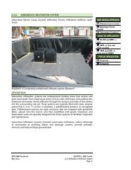
Figure 4.1-g: Subsurface Infiltrati
- Page 172:
Table 4.1-4: Subsurface Infiltratio
- Page 175 and 176:
Advantages• Recycles roof stormwa
- Page 177 and 178:
CHAPTER 4: BMP ToolkitTRPA BMP Hand
- Page 179 and 180:
industrial properties, vehicle fuel
- Page 181 and 182:
INSPECTION AND MAINTENANCE• Inspe
- Page 183 and 184:
DESIGN CONSIDERATIONS• When using
- Page 185 and 186:
Table 4.1-5: Vegetated Filter Strip
- Page 187 and 188:
Figure 4.1-h: Level SpreaderCHAPTER
- Page 189 and 190:
CONTENTS4.2 Pollutant Source Contro
- Page 191 and 192:
4.2 POLLUTANT SOURCE CONTROLUrban l
- Page 193 and 194:
4.2.1.1 ABRASIVE AND DEICER MANAGEM
- Page 195 and 196:
Abrasives and deicers should be sto
- Page 197 and 198:
4.2.1.2 STREET SWEEPINGDESCRIPTIONS
- Page 199 and 200:
OPERATION CONSIDERATIONS• For roa
- Page 201 and 202:
4.2.1.3 SNOW STORAGEDESCRIPTIONSnow
- Page 203 and 204:
• Clearly identify the boundaries
- Page 205 and 206:
4.2.2 SLOPE STABILIZATIONVegetated
- Page 207 and 208:
4.2.2.1 VEGETATED SLOPE STABILIZATI
- Page 209 and 210:
INSTALLATION CONSIDERATIONSGeneral
- Page 211 and 212:
Figure 4.2-b: Willow WattleTRPA BMP
- Page 213 and 214:
Live stakes.• Select live stakes
- Page 215 and 216:
4.2.2.2 TERRACINGAlternate Names: B
- Page 217 and 218:
INSPECTION AND MAINTENANCE• If pr
- Page 219 and 220:
Figure 4.2-c: Terrace Retaining Wal
- Page 221 and 222:
4.2.2.3 RETAINING WALLAlternate Nam
- Page 223 and 224:
• Rock walls are porous and provi
- Page 225 and 226:
Table 4.2-2: Retaining Wall Inspect
- Page 227 and 228:
Figure 4.2-e: Stacked Rock WallTRPA
- Page 229 and 230:
4.2.2.4 RIPRAPAlternative Names: Ro
- Page 231 and 232:
INSTALLATION CONSIDERATIONS• If d
- Page 233 and 234:
Figure 4.2-f: Riprap Slope Protecti
- Page 235 and 236:
4.2.2.5 SLOPE SHAPINGAlternative Na
- Page 237 and 238:
stabilization techniques described
- Page 239 and 240:
Figure 4.2-i: Contour FurrowsTRPA B
- Page 241 and 242:
4.2.3 SOIL STABILIZATION (NON-VEGET
- Page 243 and 244:
4.2.3.1 PAVING PARKING AREAS AND RO
- Page 245 and 246:
• On a relatively level site, gra
- Page 247 and 248:
Figure 4.2-j: Examples of Alternati
- Page 249 and 250:
4.2.3.2 BARE SOIL PROTECTIONAlterna
- Page 251 and 252:
Advantages• Prevents transport of
- Page 253 and 254:
INSTALLATION• Install permeable g
- Page 255 and 256:
4.2.3.3 DECK ARMORAlternative Names
- Page 257 and 258:
INSPECTION AND MAINTENANCE• Inspe
- Page 259 and 260:
4.2.3.4 PARKING AND VEHICLE BARRIER
- Page 261 and 262:
Figure 4.2-m: Parking BarriersTRPA
- Page 263 and 264:
4.2.4 WASTE MANAGEMENT AND MATERIAL
- Page 265 and 266:
4.2.4.1 DUMPSTER MANAGEMENTAlternat
- Page 267 and 268:
Make sure dumpsters are closed, lat
- Page 269 and 270:
4.2.4.2 HAZARDOUS MATERIAL MANAGEME
- Page 271 and 272:
• When wind, rain, snow, or satur
- Page 273 and 274:
Remove contaminated soil and dispos
- Page 275 and 276:
4.2.4.3 NURSERY FACILITY MANAGEMENT
- Page 277 and 278:
and enters ground or surface waters
- Page 279 and 280:
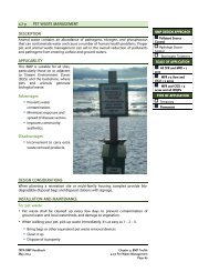
4.2.4.4 PET WASTE MANAGEMENTDESCRIP
- Page 281 and 282:
Some diseases associated with pet w
- Page 283 and 284:
4.2.4.5 LIVESTOCK FACILITY MANAGEME
- Page 285 and 286:
withstand grazing). Livestock grazi
- Page 287 and 288:
4.2.4.6 POOL AND HOT TUB MANAGEMENT
- Page 289 and 290:
4.2.4.7 VEHICLE WASHINGAlternative
- Page 291 and 292:
Additional considerations and proce
- Page 293 and 294:
CONTENTS4.3 Stormwater Collection a
- Page 295 and 296:
4.3 STORMWATER COLLECTION AND CONVE
- Page 297 and 298:
4.3.1.1 CULVERTAlternative Names: C
- Page 299 and 300:
• Design culverts to accommodate
- Page 301 and 302:
Table 4.3-1: Culvert Inspection and
- Page 303 and 304:
4.3.1.2 CURB AND GUTTERDESCRIPTIONC
- Page 305 and 306:
curb cut into an adjacent surface-s
- Page 307 and 308:
Figure 4.3-a: Curb BreakTRPA BMP Ha
- Page 309 and 310:
4.3.1.3 STORM DRAINAlternative Name
- Page 311 and 312:
INSTALLATION CONSIDERATIONS• Repa
- Page 313 and 314:
4.3.1.4 OUTLET PROTECTIONAlternativ
- Page 315 and 316:
Maintenance crews should be prepare
- Page 317 and 318:
Table 4.3-3: Outlet Protection Insp
- Page 319 and 320:
4.3.1.5 DRAIN INLETAlternate Names:
- Page 321 and 322:
• Determine if a drain inlet will
- Page 323 and 324:
4.3.1.6 FLOW SPLITTERAlternate Name
- Page 325 and 326:
Figure 4.3-d: Flow SplitterTRPA BMP
- Page 327 and 328:
4.3.1.7 SLOTTED CHANNEL DRAINAltern
- Page 329 and 330:
Table 4.3-4: Slotted Channel Drain
- Page 331 and 332:
4.3.1.8 A/C SWALEAlternative Names:
- Page 333 and 334:
flow, and structural damage and ens
- Page 335 and 336:
Figure 4.3-f: Pavement SwaleTRPA BM
- Page 337 and 338:
4.3.1.9 SUBSURFACE DRAINAlternate N
- Page 339 and 340:
Table 4.3-6: Subsurface Drain Inspe
- Page 341 and 342:
4.3.1.10 ROCK LINED AND VEGETATED S
- Page 343 and 344:
INSTALLATION CONSIDERATIONS• Use
- Page 345 and 346:
Figure 4.3-h: Rock Lined SwaleTRPA
- Page 347 and 348:
4.3.1.11 CHECK DAMSAlternative Name
- Page 349 and 350:
• Porous check dams: Low piled or
- Page 351 and 352:
Figure 4.3-j: Check DamTRPA BMP Han
- Page 353 and 354:
LIST OF FIGURESFigure 4.4-a: Wet Ba
- Page 355 and 356:
and grease, and some nutrients). We
- Page 357 and 358:
• Wet basins may be particularly
- Page 359 and 360:
• Where possible, pipe slopes sho
- Page 361 and 362:
EFFECTIVENESS CONSIDERATIONSWet bas
- Page 363 and 364:
Chapter 4: BMP ToolkitTRPA BMP Hand
- Page 365 and 366:
Advantages• Promotes removal of s
- Page 367 and 368:
• Irrigate vegetation as necessar
- Page 369 and 370:
Chapter 4: BMP ToolkitTRPA BMP Hand
- Page 371 and 372:
• When outlet designs are used fo
- Page 373 and 374:
Table 4.4-2: Dry Basin Inspection a
- Page 375 and 376:
EFFECTIVENESS CONSIDERATIONSDry bas
- Page 377 and 378:
Chapter 4: BMP ToolkitTRPA BMP Hand
- Page 379 and 380:
Chapter 4: BMP ToolkitTRPA BMP Hand
- Page 381 and 382:
• Typically a dropinlet insert pr
- Page 383 and 384:
Chapter 4: BMP ToolkitTRPA BMP Hand
- Page 385 and 386:
DESIGN CONSIDERATIONSThe following
- Page 387 and 388:
Figure 4.4-d: Subsurface Infiltrati
- Page 389 and 390:
Chapter 4: BMP ToolkitTRPA BMP Hand
- Page 391 and 392:
• When considering the small spac
- Page 393 and 394:
Chapter 4: BMP ToolkitTRPA BMP Hand
- Page 395 and 396:
A media filter installed on a comme
- Page 397 and 398:
adequate filtration capacity. After
- Page 399 and 400:
Three performance monitoring studie
- Page 401 and 402:
Residential driveway with a slotted
- Page 403 and 404:
Table 4.4-3: Sediment Trap Inspecti
- Page 405 and 406:
Figure 4.4-f: Sediment Trap #2Chapt
- Page 407 and 408:
LIST OF FIGURESFigure 4.5-a: Constr
- Page 409 and 410:
Weather is an important considerati
- Page 411 and 412:
Chapter 4: BMP ToolkitTRPA BMP Hand
- Page 413 and 414:
of the project parcel (or the forma
- Page 415 and 416:
• Enforce and protect temporary B
- Page 417 and 418:
• Make maximum use of natural bar
- Page 419 and 420:
Chapter 4: BMP ToolkitTRPA BMP Hand
- Page 421 and 422:
DESIGN CONSIDERATIONS• Shallow gr
- Page 423 and 424:
• If groundwater is suspected to
- Page 425 and 426:
Chapter 4: BMP ToolkitTRPA BMP Hand
- Page 427 and 428:
• Allows for active construction
- Page 429 and 430:
Figure 4.5-c: Flexible DowndrainCha
- Page 431 and 432:
Figure 4.5-e: Chute or FlumeChapter
- Page 433 and 434:
A. Pumped diversions: Effective for
- Page 435 and 436:
INSPECTION AND MAINTENANCE• Inspe
- Page 437 and 438:
DESIGN CONSIDERATIONS• During the
- Page 439 and 440:
professional arborist. While prunin
- Page 441 and 442:
Chapter 4: BMP ToolkitTRPA BMP Hand
- Page 443 and 444:
INSPECTION AND MAINTENANCE• Inspe
- Page 445 and 446:
• Complaints regarding dust pollu
- Page 447 and 448:
Repeat several times daily as neces
- Page 449 and 450:
• If multiple vehicles are expect
- Page 451 and 452:
Figure 4.5-h: Vehicle Tracking Cont
- Page 453 and 454:
INSTALLATION• At inactive constru
- Page 455 and 456:
Chapter 4: BMP ToolkitTRPA BMP Hand
- Page 457 and 458:
• Refer to Section 4.5.1.11, Mate
- Page 459 and 460:
• Keep appropriate spill clean-up
- Page 461 and 462:
Chapter 4: BMP ToolkitTRPA BMP Hand
- Page 463 and 464:
INSTALLATION CONSIDERATIONSTopsoil
- Page 465 and 466:
Chapter 4: BMP ToolkitTRPA BMP Hand
- Page 467 and 468:
scrubbing with a brush by hand) ins
- Page 469 and 470:
Chapter 4: BMP ToolkitTRPA BMP Hand
- Page 471 and 472:
and/or gravel bags. Extend barriers
- Page 473 and 474:
Chapter 4: BMP ToolkitTRPA BMP Hand
- Page 475 and 476:
Chapter 4: BMP ToolkitTRPA BMP Hand
- Page 477 and 478:
• Dispose of sediment swept from
- Page 479 and 480:
• Do not use straw bale drain inl
- Page 481 and 482:
INSPECTION AND MAINTENANCE• Inspe
- Page 483 and 484:
Chapter 4: BMP ToolkitTRPA BMP Hand
- Page 485 and 486:
• Need frequent inspection and ma
- Page 487 and 488:
• Fiber rolls at the toe of slope
- Page 489 and 490:
Chapter 4: BMP ToolkitTRPA BMP Hand
- Page 491 and 492:
DESIGN CONSIDERATIONS• From fabri
- Page 493 and 494:
This silt fence is not functioning
- Page 495 and 496:
Figure 4.5-n: Silt Fence PlacementC
- Page 497 and 498:
• Rocks, debris, or inadequate an
- Page 499 and 500:
Figure 4.5-o: Erosion Control Blank
- Page 501 and 502:
Chapter 4: BMP ToolkitTRPA BMP Hand
- Page 503 and 504:
Advantages• Can be applied in ste
- Page 505 and 506:
CHAPTER 5: SOIL AND VEGETATIONMANAG
- Page 507 and 508:
5.2.1 SOIL RESTORATIONTopsoil devel
- Page 509 and 510:
Native and adapted plants integrate
- Page 511 and 512:
Before using turf on small commerci
- Page 513 and 514:
5.3.2.1 FERTILIZERSLake Tahoe is na
- Page 515 and 516:
5.3.2.2 IRRIGATIONProper irrigation
- Page 517 and 518:
that no detectable concentration of
- Page 519 and 520:
germinate if the compost does not r
- Page 521 and 522:
Although drought tolerant and able
- Page 523 and 524:
Figure 5-b: Fire Districts MapTRPA
- Page 525 and 526:
available for use located at the en
- Page 527 and 528:
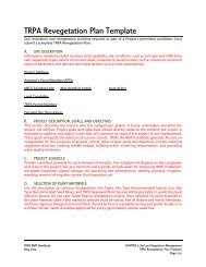
D. INSTALLATION OF PLANT MATERIALSD
- Page 529:
WATERINGDescribe irrigation system,
- Page 532 and 533:
PLANT MATERIALSSpecies(Botanical Na
- Page 534 and 535:
Describe soil stabilization practic
- Page 536 and 537:
DatesSeptember 30 and June 1to Sept
- Page 538 and 539:
areas resulting from rough-grading
- Page 540 and 541:
oadcast seed using hand-held seeder
- Page 542 and 543:
another species or size will be mad
- Page 544 and 545:
Attachment A. BMPs• BMP 4.5.1.5 -
- Page 547 and 548:
Fertilizer Management Plan Template
- Page 549 and 550:
I. PROJECT AND SITE DESCRIPTIONDesc
- Page 551 and 552:
Fertilizer Management Plan ExampleF
- Page 553:
C. RATES AND MEANS OF APPLICATIONZo
- Page 557 and 558:
Table 5-2: Site Type Recommended Sp
- Page 559 and 560:
SITE TYPE RECOMMENDED SPECIES LISTW
- Page 561 and 562:
Table 5-3: Site Type Recommended Se
- Page 563 and 564:
Table 5-4: Attributes of Suitable a
- Page 565 and 566:
TRPA APPROVED PLANT SPECIES ATTRIBU
- Page 567 and 568:
TRPA APPROVED PLANT SPECIES ATTRIBU
- Page 569 and 570:
CHAPTER 6: INSPECTION, MAINTENANCE,
- Page 571 and 572:
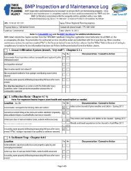
6.3 PROJECTS 1 TO 5 ACRES AND ALL C
- Page 573 and 574:
prevent sediment discharge onto an
- Page 575 and 576:
6.5 MAINTENANCE AGREEMENTS AND BMP-
- Page 577 and 578:
SMALL RESIDENTIAL BMP INSPECTION,MA
- Page 579 and 580:
Overall siteEXAMPLE INSPECTION AND
- Page 581 and 582:
EXAMPLE INSPECTION AND MAINTENANCE
- Page 583 and 584:
3. Sample number shall be large eno
- Page 585 and 586:
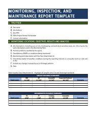
Photo Monitoring (Attachment C)DATE
- Page 587 and 588:
1. SITE DESCRIPTIONThis Sample Site
- Page 589 and 590:
ATTACHMENT ASITE PLAN
- Page 591 and 592:
ATTACHMENT CPHOTO- MONITORING
- Page 593 and 594:
CHAPTER 7: PERMITTING7.1 PURPOSE AN
- Page 595 and 596:
considered an exempt activity. Exem
- Page 597 and 598:
Parcels developed after July 1987 a
- Page 599 and 600:
7.5 SECURITIESSecurities are charge
- Page 601 and 602:
and shorezone management. 6 Althoug
- Page 603 and 604:
Figure 8-a: Planning Approaches for
- Page 605 and 606:
Adaptation and retreat requires the
- Page 607 and 608:
comparing and contrasting alternati
- Page 609 and 610:
8.1.7 REGULATORY PERMITTINGWhen a l
- Page 611 and 612:
Figure 8-b: Shorezone Tolerance Dis
- Page 613 and 614:
infiltrate into dune sands because
- Page 615 and 616:
Figure 8-c: The Shorezone of Lake T
- Page 617 and 618:
8.1.8.3 BACKSHORE SETBACKS AND BUFF
- Page 619 and 620:
FISHERIES1. Is the project area, in
- Page 621 and 622:
TYPESoldier PileGravitySUPPORTSTRUC
- Page 623 and 624:
Figure 8-g illustrates a hypothetic
- Page 625 and 626:
is generally limited in Lake Tahoe.
- Page 627 and 628:
Figure 8-h: Typical Anchored Sheet
- Page 629 and 630:
8.3 STATIC REVETMENTS8.3.1 OVERVIEW
- Page 631 and 632:
evetments. Additionally, excessive
- Page 633 and 634:
not always conservative enough and
- Page 635 and 636:
8.4 DYNAMIC REVETMENTS8.4.1 OVERVIE
- Page 637 and 638:
major storms. A full review of this
- Page 639 and 640:
Figure 8-l: Potential Modes of Fail
- Page 641 and 642:
Table 8-12: Overview of the Advanta
- Page 643 and 644:
h 1. 57(Equation 5.1)cH eWhere:he
- Page 645 and 646:
(1) The A values above, some to fou
- Page 647 and 648:
8.6 JETTIES8.6.1 OVERVIEWIn Lake Ta
- Page 649 and 650:
• Jetties must extend sufficientl
- Page 651 and 652:
ADVANTAGES• Provides wave protect
- Page 653 and 654:
Figure 8-n: Fixed Breakwater Design
- Page 655 and 656:
Table 8-16: Advantages and Disadvan
- Page 657 and 658:
8.9 DREDGING8.9.1 OVERVIEWDredging
- Page 659 and 660:
There are various types of dredges.
- Page 661 and 662:
Transportation and placement of dre
- Page 663 and 664:
The following subjects are typicall
- Page 665 and 666:
weeks); longer durations or extensi
- Page 667 and 668:
8.10.4 INSTALLATIONInstall turbidit
- Page 669 and 670:
8.11 BOATING DISCHARGE CONTROL AND
- Page 671 and 672:
facilities, which may decrease loca
- Page 673 and 674:
• These petroleum products shall
- Page 675 and 676:
8.11.4 INSTALLATIONMuch of the inst
- Page 677 and 678:
TRPA will require a Water Quality M
- Page 679 and 680:
significant grading, dredging, or f
- Page 681 and 682:
Table 8-21: Considerations for Boat
- Page 683 and 684:
8.13 SITE CHARACTERIZATION CHECKLIS
- Page 685 and 686:
In addition to the modeling require
- Page 687 and 688:
emote imagery, and the development
- Page 689 and 690:
etc.) and chemical (dissolved oxyge
- Page 691 and 692:
Noise pollution from dredging or ot
- Page 693 and 694:
8.15 BIBLIOGRAPHYAhrens, J.P., John
- Page 695 and 696:
Komar, P. D., and McDougal, W. G. (
- Page 697 and 698:
U.S. Army Corps of Engineers (1966)
- Page 699 and 700:
Figure 8-q: Fetch Definition 0.00
- Page 701 and 702:
Figure 8-s Wave Height NomographCHA
- Page 703 and 704:
Figure 8-t: Wave Run-UpBased on the
- Page 705 and 706:
8.16.1.4 CALCULATING WAVE HEIGHT AT
- Page 707 and 708:
Case 1: the toe of the protective m
- Page 709 and 710:
• Calculate the remaining height
- Page 711 and 712:
FOR NON-BREAKING WAVES:W50,lbs1.27H
- Page 713 and 714:
Bailey Land Capability System (Land
- Page 715 and 716:
marks shoals or rocks; a whistling
- Page 717 and 718:
DuffThe decomposed mulch layer of p
- Page 719 and 720:
Infiltration FacilityA device used
- Page 721 and 722:
Native PlantA plant that is endemic
- Page 723 and 724:
Revetment1) A facing of stone, conc
- Page 725 and 726:
Shear StressShear stress is the res
- Page 727 and 728:
Water Quality Management Plan for t
- Page 729 and 730:
UpdriftThe direction opposite that
- Page 731 and 732:
FSP - Fine Sediment ParticlesGUI -
- Page 733:
Tahoe RCD - Tahoe Resource Conserva