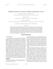
Hurricanes: Their Nature and Impacts on Society - Climate Science ...
Hurricanes: Their Nature and Impacts on Society - Climate Science ...
Hurricanes: Their Nature and Impacts on Society - Climate Science ...

You also want an ePaper? Increase the reach of your titles
YUMPU automatically turns print PDFs into web optimized ePapers that Google loves.
102 HURRICANES: THEIR NATURE AND IMPACT ON SOCIETY<br />
storm. The winds representing the steering current are easterly in the absence<br />
of the isl<str<strong>on</strong>g>and</str<strong>on</strong>g>. With the isl<str<strong>on</strong>g>and</str<strong>on</strong>g> present to block the flow (even without a<br />
hurricane present) the winds would turn southerly to the east of the isl<str<strong>on</strong>g>and</str<strong>on</strong>g>.<br />
With the hurricane present as shown, the circulati<strong>on</strong> around the storm,<br />
interacting with the simulated terrain, resulted in the path plotted in the figure,<br />
which is to the right of the steering current in the absence of the storm. In the<br />
absence of the isl<str<strong>on</strong>g>and</str<strong>on</strong>g>, the hurricane would have moved <strong>on</strong> a general westward<br />
track. In the Atlantic regi<strong>on</strong>, terrain effects of this type occur associated with<br />
the larger isl<str<strong>on</strong>g>and</str<strong>on</strong>g>s of the Caribbean (Cuba, Hispafiola). Flatter l<str<strong>on</strong>g>and</str<strong>on</strong>g>scape, such<br />
as the Yucatan Peninsula <str<strong>on</strong>g>and</str<strong>on</strong>g> Florida, <str<strong>on</strong>g>and</str<strong>on</strong>g> the smaller isl<str<strong>on</strong>g>and</str<strong>on</strong>g>s of the<br />
Caribbean <str<strong>on</strong>g>and</str<strong>on</strong>g> Atlantic have much less of an effect <strong>on</strong> cycl<strong>on</strong>e tracks.<br />
4.4 INTERNAL F1..0W<br />
Even when the steering current is relatively uniform <str<strong>on</strong>g>and</str<strong>on</strong>g> steady, however,<br />
hurricane moti<strong>on</strong> is often somewhat irregular. For example, Figure 4.6 illustrates<br />
the oscillati<strong>on</strong> of the movement of the eye of Hurricane Dora (1964) as<br />
it progressed <strong>on</strong> a general track westward towards the upper east coast of<br />
Florida. This oscillati<strong>on</strong> is primarily due to forces within the hurricane. In<br />
Hurricane Anita (1977), the eye <str<strong>on</strong>g>and</str<strong>on</strong>g> eye wall were observed by aircraft to<br />
have an oscillati<strong>on</strong> around the mean track with an amplitude of 3 miles (5<br />
km) <str<strong>on</strong>g>and</str<strong>on</strong>g> a period of 6 hours (Willoughby 1979). This small-scale irregular<br />
behavior of the center of the storm has been attributed to the thunderstorms<br />
<str<strong>on</strong>g>and</str<strong>on</strong>g> str<strong>on</strong>g winds in the eye wall regi<strong>on</strong>, which causes the center to deviate<br />
short distances to the left or right of its track, similar to the moti<strong>on</strong> of a<br />
spinning top. The larger circulati<strong>on</strong> envelope of the hurricane, with its much<br />
greater inertia, more closely follows the steering current <str<strong>on</strong>g>and</str<strong>on</strong>g> tends to force the<br />
eye wall back towards the center of the larger circulati<strong>on</strong>.<br />
4.5 TROPICAL CYCLONE TRACK, INTENSITY, AND<br />
SEASONAL FORECASTING<br />
Hurricane predicti<strong>on</strong>s in the United States are prepared at the Nati<strong>on</strong>al<br />
Hurricane Center in Miami, Florida for tropical cycl<strong>on</strong>es in the Gulf of<br />
Mexico, the Caribbean <str<strong>on</strong>g>and</str<strong>on</strong>g> the Atlantic Ocean <str<strong>on</strong>g>and</str<strong>on</strong>g> the eastern Pacific (Figure<br />
4.7). Other regi<strong>on</strong>s of resp<strong>on</strong>sibility are shown in Appendix D.<br />
4.5.1 Tropical cycl<strong>on</strong>e track predicti<strong>on</strong>s<br />
The Nati<strong>on</strong>al Hurricane Center utilizes a suite of models to forecast tropical<br />
cycl<strong>on</strong>e tracks (DeMaria 1995; Abers<strong>on</strong> <str<strong>on</strong>g>and</str<strong>on</strong>g> DeMaria 1994). They include<br />
<strong>on</strong>e based <strong>on</strong> climatology <str<strong>on</strong>g>and</str<strong>on</strong>g> persistence (CLIPER), a statistical model which