- Page 1:
INFORMATION TO USERS This manuscrip
- Page 5 and 6:
Urbanization, Urban Policy and City
- Page 7 and 8:
In presenting this dissertation in
- Page 9 and 10:
state in contemporary urban develop
- Page 11 and 12:
IV. Two Decades of Turmoil (1953-19
- Page 13 and 14:
CHAPTER VIII State-led Urbanization
- Page 15 and 16:
LIST OF FIGURES Number Page 1.1 Map
- Page 17 and 18:
CHAPTER I URBANIZATION, URBAN POLIC
- Page 19 and 20:
3 the same time, industrialization'
- Page 21 and 22:
5 macro-social change. He states th
- Page 23 and 24:
7 In addition to this form of livin
- Page 25 and 26:
9 In most cases, even physical plan
- Page 27 and 28:
11 V. RESEARCH METHODOLOGY AND STRU
- Page 29 and 30:
13 overview of the economic and pol
- Page 31 and 32:
15 research findings: an evaluation
- Page 33 and 34:
17 15 Quoted by C. G. Pickvance, "C
- Page 35 and 36:
19 resulted in problematic urbaniza
- Page 37 and 38:
21 Prophet taught that the Biblical
- Page 39 and 40:
23 and/or transformed already exist
- Page 41 and 42:
25 differentiation between the town
- Page 43 and 44:
Those who fled Makkah with the Prop
- Page 45 and 46:
29 left unbuilt for the use of vari
- Page 47 and 48:
31 The origin of the schools of tho
- Page 49 and 50:
33 3. THE CIRCULATION SPACE. The de
- Page 51 and 52:
35 duties including the supervision
- Page 53 and 54:
37 contrasted qualities, between th
- Page 55 and 56:
39 found intimate, lasting bonds of
- Page 57 and 58:
41 checkered early history of eclec
- Page 59 and 60:
43 IV. CRITIQUE OF THE MODEL Accord
- Page 61 and 62:
45 however contributed decisively t
- Page 63 and 64:
47 So, Islam's perception of dunia
- Page 65 and 66:
49 guild, all regulated in the ligh
- Page 67 and 68:
51 Prophet. By doing so , a person
- Page 69 and 70:
53 Kenneth Brown (1986b), 77. M. Bo
- Page 71 and 72:
CHAPTER HI FORCES OF CHANGE IN SAUD
- Page 73 and 74:
attentions from the local level to
- Page 75 and 76:
59 written document spelling out it
- Page 77 and 78:
61 was espoused to create outlets f
- Page 79 and 80:
63 states, Abdul-Aziz mustered his
- Page 81 and 82:
65 his extended family's living dep
- Page 83 and 84:
67 The decline was also partly caus
- Page 85 and 86:
69 toward a polyarchy of tribes lur
- Page 87 and 88:
71 Table 3.1 Oil Production and Rev
- Page 89 and 90:
73 With the shift from traditional,
- Page 91 and 92:
75 which gave the United States acc
- Page 93 and 94:
77 primary and secondary schools, i
- Page 95 and 96:
79 the urgent need to shift gears t
- Page 97 and 98:
81 This intermittent process of sed
- Page 99 and 100:
83 petitioning of the central gover
- Page 101 and 102:
85 leaps toward modernity. And inst
- Page 103 and 104:
87 of surplus population in urban c
- Page 105 and 106:
89 the premise that Ml benefits of
- Page 107 and 108:
91 imports of raw materials and mac
- Page 109 and 110:
93 oil exports and infrastructural
- Page 111 and 112:
95 determined by social status. The
- Page 113 and 114:
97 self-employed peasant earned a m
- Page 115 and 116:
99 small-arms and ammunitions facto
- Page 117 and 118:
101 TABLE 3.5 Top Cities with Popul
- Page 119 and 120:
103 SUMMARY In what seemed at the b
- Page 121 and 122:
105 financial support, complaints,
- Page 123 and 124:
107 Abdul-Rahman H. Al-Said, "The T
- Page 125 and 126:
109 64 N.C. Grill, "Urbanization In
- Page 127 and 128:
Ill My discussion starts with a his
- Page 129 and 130:
113 the modern state, advocating th
- Page 131 and 132:
115 more importance on "means" and
- Page 133 and 134:
117 states "A more important proble
- Page 135 and 136:
119 planning toward expertise and t
- Page 137 and 138:
121 With oil income available to th
- Page 139 and 140:
123 in. SAUDI GOVERNMENT STRUCTURE
- Page 141 and 142:
125 sites. The King, who was advise
- Page 143 and 144:
127 municipalities, 43 village clus
- Page 145 and 146:
129 bustling plexus/center of immen
- Page 147 and 148:
131 services, for the new annexes o
- Page 149 and 150:
133 compensations plus a thirty per
- Page 151 and 152:
135 settlements, nomads and expatri
- Page 153 and 154:
137 the royal family, old-fashioned
- Page 155 and 156:
139 The five-year plan comprises (1
- Page 157 and 158:
141 to sort urban activities into d
- Page 159 and 160:
143 Yanbu occupies public land of 8
- Page 161 and 162:
145 land uses backed with detailed
- Page 163 and 164:
147 imported models, chiefly Wester
- Page 165 and 166:
149 15 Self (1985), 877. 16 Ibid. L
- Page 167 and 168:
151 big multi-story apartment build
- Page 169 and 170:
CHAPTER V MAJOR TRADITIONAL URBAN A
- Page 171 and 172:
155 A. Semi-Local Autonomy and Gove
- Page 173 and 174:
157 development, no master plans, a
- Page 175 and 176:
159 charities, waqf. For instance,
- Page 177 and 178:
161 faced with increasing world dem
- Page 179 and 180:
163 Notes to Chapter V 1 Six major
- Page 181 and 182:
165 The relationship between neighb
- Page 183 and 184:
CHAPTER VI RIYADH: FROM WALLED TOWN
- Page 185 and 186:
169 iMusmak Built Area '-'r.identir
- Page 187 and 188:
171 and saucepans, wooden chests of
- Page 189 and 190:
173 town inhabited mostly by the un
- Page 191 and 192:
175 Muslim center, when compared to
- Page 193 and 194: 177 In the oases and towns, propert
- Page 195 and 196: 179 tribal chiefs and influential t
- Page 197 and 198: 181 improved economy and its increa
- Page 199 and 200: 183 into a nuclei of the Matar subu
- Page 201 and 202: 185 as practiced by Amanat Ar-Riyad
- Page 203 and 204: 187 [AOH \*-\K il 1975 Figure 6.5 R
- Page 205 and 206: 189 land, reflected the Saudi econo
- Page 207 and 208: 191 notion, that is, the realizatio
- Page 209 and 210: 193 It I j i 1 i 1 i Bv gy- - 1 ili
- Page 211 and 212: 195 household itself. Wealthy peopl
- Page 213 and 214: 197 communities. Aramco introduced
- Page 215 and 216: 199 heritage in an era of technolog
- Page 217 and 218: Figure 6.10 Riyadh: King Saud's roy
- Page 219 and 220: 203 LOCALITY PLAN V Figure 6.12 Al-
- Page 221 and 222: 205 leading to the airport. In cont
- Page 223 and 224: 207 on the urban scene. His reforms
- Page 225 and 226: Table 6.1 Number of Permits (Constr
- Page 227 and 228: Municipally population (1940s) Tabl
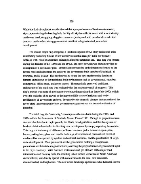
- Page 229 and 230: 213 expanding cities. Master city p
- Page 231 and 232: 215 Commerce. Busincu tad Ciric |QQ
- Page 233 and 234: 217 attention to economic determina
- Page 235 and 236: 219 zr/M Khjzian J T.\. Street Figu
- Page 237 and 238: 221 urban growth consumed most of t
- Page 239 and 240: 223 government spending fueled city
- Page 241 and 242: 225 paying consideration to the cen
- Page 243: 227 bring more customers to the dow
- Page 247 and 248: 231 mollifying and complementing th
- Page 249 and 250: 233 The modern urban form possesses
- Page 251 and 252: 235 developed land use. Another 13
- Page 253 and 254: 237 in 1950, and the transfer of th
- Page 255 and 256: 239 Table 6.5 Riyadh's Land Uses an
- Page 257 and 258: 241 expertise impeded the implement
- Page 259 and 260: 243 16 Adeeb Faris. Ar Riyadh: Wath
- Page 261 and 262: 245 36 H. St J. B. Philby, "Riyadh:
- Page 263 and 264: 247 59 K. Brown. Middle Eastern Cit
- Page 265 and 266: 249 (valleys), Arar and Badanah, wh
- Page 267 and 268: 251 The unprecedented venture of bu
- Page 269 and 270: 253 Between 1973 and 1986 Arar witn
- Page 271 and 272: 255 even shrank considerably follow
- Page 273 and 274: 257 JL IgUi v / • Arar's layout d
- Page 275 and 276: 259 Doxiadis Plan, (5) militarizati
- Page 277 and 278: 261 Aththouqbah, the Tapline compan
- Page 279 and 280: 263 processing and assembly, etc.)
- Page 281 and 282: 265 rising oil revenues. 25 During
- Page 283 and 284: 267 In 1976, the government authori
- Page 285 and 286: 269 rv^ Figure 7.5 King Abdul-Aziz
- Page 287 and 288: 271 I— _r
- Page 289 and 290: 273 ; 'i'% Residential Area rV s3\^
- Page 291 and 292: 275 j "Hf \\\X j»Lfc AR'AR FINAl M
- Page 293 and 294: 277 them to seek better and larger
- Page 295 and 296:
279 mosques and the like. The numbe
- Page 297 and 298:
281 construction permits issued by
- Page 299 and 300:
283 Figure 7.11 The Urban Domain fo
- Page 301 and 302:
285 built environment, all consiste
- Page 303 and 304:
287 Notes to Chapter VII 1 Helmut M
- Page 305 and 306:
289 free of charge. If such person
- Page 307 and 308:
291 47 A1 Hathloul and Amroush (198
- Page 309 and 310:
293 (inevitably calling for the imp
- Page 311 and 312:
295 Ashsha'eeb's topography helped
- Page 313 and 314:
297 impact of these series of battl
- Page 315 and 316:
299 The historical development of H
- Page 317 and 318:
301 Mohammad (1803-14) the grandson
- Page 319 and 320:
303 rectangular forms. In 1965-66 t
- Page 321 and 322:
305 The built form of present Hurai
- Page 323 and 324:
307 dilapidated, mud houses had bec
- Page 325 and 326:
309 fr-xttxw^XvSNsvXvWx^ww&i-xyrX ,
- Page 327 and 328:
311 responsible for issuing buildin
- Page 329 and 330:
313 urban growth and management mus
- Page 331 and 332:
315 Figure 8.11 Starting during the
- Page 333 and 334:
317 to virtually all those who appl
- Page 335 and 336:
319 lid t)3acs • 1 11 iffrhj =3 a
- Page 337 and 338:
321 Huraimla. 22 Between 1970 and 1
- Page 339 and 340:
323 In Huraimla, to encourage and e
- Page 341 and 342:
325 compared to the traditional bui
- Page 343 and 344:
327 Notes to Chapter VIII 1 H. St.
- Page 345 and 346:
329 21 For example, the estate al A
- Page 347 and 348:
331 polarization of power under the
- Page 349 and 350:
333 development. This requires the
- Page 351 and 352:
335 residential suburbs, megalomani
- Page 353 and 354:
337 branches of the central governm
- Page 355 and 356:
339 Whilst steps toward integrated
- Page 357 and 358:
341 such a dynamism to suburban gro
- Page 359 and 360:
343 HI. ENVISIONING THE PLURALISTIC
- Page 361 and 362:
345 government, a greater flexibili
- Page 363 and 364:
347 Notes to Chapter IX 1 The abili
- Page 365 and 366:
BIBLIOGRAPHY Abdulaal, Walead. "Imp
- Page 367 and 368:
351 A1 Rashid, Ibrahim. Documents o
- Page 369 and 370:
353 Bligh, Alexander. "The Saudi Re
- Page 371 and 372:
355 Doxiadis Associates. Northern R
- Page 373 and 374:
357 "Governmental Services and Inte
- Page 375 and 376:
359 Huntington, Samuel P. Political
- Page 377 and 378:
361 Ministry of Communications. Hig
- Page 379 and 380:
363 Morris, A.E.J. History of Urban
- Page 381 and 382:
365 Salamah, Gasssan. "Saudi Arabia
- Page 383 and 384:
367 Wilber, C. and K. Jameson. "Par