Makivik Magazine Issue 90

You also want an ePaper? Increase the reach of your titles
YUMPU automatically turns print PDFs into web optimized ePapers that Google loves.
kN[7u 3vspn3†5<br />
3vspnDt[iq5 23<br />
Nunavik Research<br />
Fact Sheet 23<br />
mr[4 eu3Dxq5<br />
98<br />
Polar Bear Aerial Survey Development<br />
An aerial survey of the Foxe Basin polar bear subpopulation during<br />
August and September 2009, led by the Government of Nunavut<br />
and the University of Minnesota in partnership with the <strong>Makivik</strong>,<br />
Parks Canada, and local hunting and trapping organizations,<br />
represents a significant step in the development of<br />
less invasive ways to monitor polar bear numbers.<br />
Biologists often have used methods that require the<br />
capture of bears to estimate population abundance. Now<br />
a prime benefit of aerial surveys is that they do not require<br />
bear capture and handling. Because they may be completed<br />
in a single season, aerial surveys may enable more rapid<br />
monitoring of polar bear populations.<br />
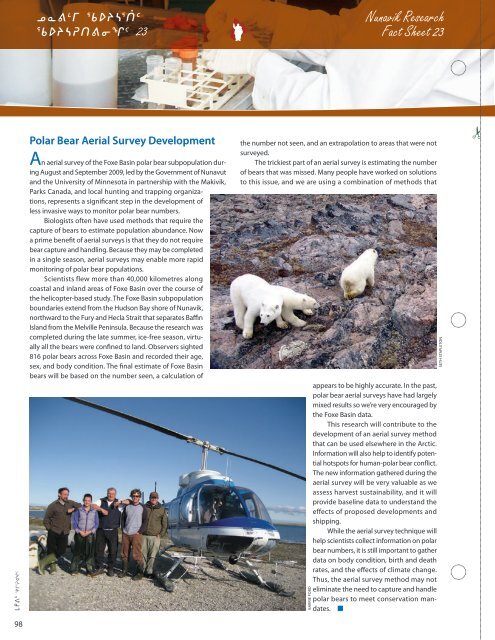
Scientists flew more than 40,000 kilometres along<br />
coastal and inland areas of Foxe Basin over the course of<br />
the helicopter-based study. The Foxe Basin subpopulation<br />
boundaries extend from the Hudson Bay shore of Nunavik,<br />
northward to the Fury and Hecla Strait that separates Baffin<br />
Island from the Melville Peninsula. Because the research was<br />
completed during the late summer, ice-free season, virtually<br />
all the bears were confined to land. Observers sighted<br />
816 polar bears across Foxe Basin and recorded their age,<br />
sex, and body condition. The final estimate of Foxe Basin<br />
bears will be based on the number seen, a calculation of<br />
the number not seen, and an extrapolation to areas that were not<br />
surveyed.<br />
The trickiest part of an aerial survey is estimating the number<br />
of bears that was missed. Many people have worked on solutions<br />
to this issue, and we are using a combination of methods that<br />
barrie ford<br />
appears to be highly accurate. In the past,<br />
polar bear aerial surveys have had largely<br />
mixed results so we’re very encouraged by<br />
the Foxe Basin data.<br />
This research will contribute to the<br />
development of an aerial survey method<br />
that can be used elsewhere in the Arctic.<br />
Information will also help to identify potential<br />
hotspots for human-polar bear conflict.<br />
The new information gathered during the<br />
aerial survey will be very valuable as we<br />
assess harvest sustainability, and it will<br />
provide baseline data to understand the<br />
effects of proposed developments and<br />
shipping.<br />
While the aerial survey technique will<br />
help scientists collect information on polar<br />
bear numbers, it is still important to gather<br />
data on body condition, birth and death<br />
rates, and the effects of climate change.<br />
Thus, the aerial survey method may not<br />
eliminate the need to capture and handle<br />
polar bears to meet conservation mandates.<br />
seth stapleton