

Dealing with salinity in Wheatbelt Valleys - Department of Water
Dealing with salinity in Wheatbelt Valleys - Department of Water
Dealing with salinity in Wheatbelt Valleys - Department of Water

You also want an ePaper? Increase the reach of your titles
YUMPU automatically turns print PDFs into web optimized ePapers that Google loves.
Ali and Coles<br />
expected under these conditions. The quality <strong>of</strong><br />
water flow<strong>in</strong>g <strong>in</strong> the dra<strong>in</strong>s decl<strong>in</strong>ed as it moved<br />
towards the downstream end <strong>of</strong> the sub-catchment.<br />
The quality <strong>of</strong> water flow<strong>in</strong>g <strong>in</strong> the dra<strong>in</strong> at P<strong>in</strong>i was<br />
relatively fresher as compared to that flow<strong>in</strong>g<br />
through the town <strong>of</strong> Narembeen. This is not an<br />
unexpected trend (Figure 4). The deterioration <strong>in</strong><br />
the dra<strong>in</strong> water quality at the Deluise site was<br />
considered to occur as a result <strong>of</strong> evaporation <strong>of</strong><br />
water <strong>in</strong> the dra<strong>in</strong> due to its isolation and role as a<br />
Dra<strong>in</strong> <strong>Water</strong> Quality (EC, mS/cm)<br />
140<br />
120<br />
100<br />
80<br />
60<br />
40<br />
P<strong>in</strong>i<br />
Latham<br />
Deluise<br />
Town<br />
1/05/00 1/06/00 1/07/00 1/08/00 1/09/00 1/10/00 1/11/00 1/12/00<br />
Time (Date)<br />
Figure 4: Temporal variation <strong>of</strong> water<br />
quality dur<strong>in</strong>g 2000 <strong>in</strong> selected dra<strong>in</strong>s<br />
(Narembeen)<br />
Dra<strong>in</strong>age Design, Construction and<br />
Ma<strong>in</strong>tenance<br />
The design, placement and ma<strong>in</strong>tenance <strong>of</strong> dra<strong>in</strong>s are<br />
critical issues that should be considered <strong>in</strong><br />
conjunction <strong>with</strong> environmental impacts. In general,<br />
the majority <strong>of</strong> deep dra<strong>in</strong>s constructed <strong>in</strong> the<br />
<strong>Wheatbelt</strong> are designed on the basis that they do not<br />
allow the entry <strong>of</strong> surface run<strong>of</strong>f. That is why only<br />
base flow is usually considered <strong>in</strong> the design <strong>of</strong> these<br />
dra<strong>in</strong>s. But due to poor protection aga<strong>in</strong>st its entry,<br />
the surface run<strong>of</strong>f usually enters <strong>in</strong>to these dra<strong>in</strong>s as a<br />
result <strong>of</strong> significant ra<strong>in</strong>fall events. Velocities<br />
generated <strong>with</strong><strong>in</strong> these dra<strong>in</strong>s dur<strong>in</strong>g heavy ra<strong>in</strong>s<br />
result <strong>in</strong> the undercutt<strong>in</strong>g <strong>of</strong> the dra<strong>in</strong> slopes and<br />
wash<strong>in</strong>g <strong>of</strong> eroded material <strong>in</strong>to the dra<strong>in</strong>s. This<br />
causes sedimentation and a drastic reduction <strong>in</strong> their<br />
effectiveness. Additionally, at locations where dra<strong>in</strong>s<br />
cross roads, the culverts are usually required. These<br />
are designed on the basis that the dra<strong>in</strong>s are for<br />
groundwater or baseflow only and, therefore, are<br />
<strong>in</strong>capable <strong>of</strong> manag<strong>in</strong>g excess surface run<strong>of</strong>f. This<br />
<strong>of</strong>ten causes extensive damage to both the dra<strong>in</strong> and<br />
the road. Spoil bank slump<strong>in</strong>g <strong>in</strong>to the dra<strong>in</strong>s is<br />
another major cause <strong>of</strong> sedimentation (Figure 6).<br />
– 6 –<br />
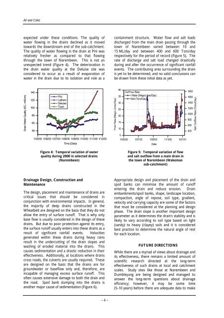
conta<strong>in</strong>ment structure. <strong>Water</strong> flow and salt loads<br />
discharged from the ma<strong>in</strong> dra<strong>in</strong> pass<strong>in</strong>g through the<br />
town <strong>of</strong> Narembeen varied between 10 and<br />
15 ML/day and between 400 and 600 Tons/day<br />
respectively for the period <strong>of</strong> record (Figure 5). The<br />
rate <strong>of</strong> discharge and salt load changed drastically<br />
dur<strong>in</strong>g and after the occurrence <strong>of</strong> significant ra<strong>in</strong>fall<br />
events. The contribut<strong>in</strong>g area surround<strong>in</strong>g the dra<strong>in</strong><br />
is yet to be determ<strong>in</strong>ed, and no valid conclusions can<br />
be drawn from these <strong>in</strong>itial data as yet.<br />
Figure 5: Temporal variation <strong>of</strong> flow<br />
and salt outflow from a ma<strong>in</strong> dra<strong>in</strong> <strong>in</strong><br />
the town <strong>of</strong> Narembeen (Wakeman<br />
sub-catchment)<br />
Appropriate design and placement <strong>of</strong> the dra<strong>in</strong> and<br />
spoil banks can m<strong>in</strong>imise the amount <strong>of</strong> run<strong>of</strong>f<br />
enter<strong>in</strong>g the dra<strong>in</strong> and reduce erosion. Dra<strong>in</strong><br />
embankments/spoil banks, shape, landscape location,<br />
compaction, angle <strong>of</strong> repose, soil type, gradient,<br />
velocity and carry<strong>in</strong>g capacity are some <strong>of</strong> the factors<br />
that must be considered at the plann<strong>in</strong>g and design<br />
phase. The dra<strong>in</strong> slope is another important design<br />
parameter as it determ<strong>in</strong>es the dra<strong>in</strong>'s stability and is<br />
likely to vary accord<strong>in</strong>g to soil type based on light<br />
(sandy) to heavy (clayey) soils and it is considered<br />
best practice to determ<strong>in</strong>e the natural angle <strong>of</strong> rest<br />
for each location.<br />
FUTURE DIRECTIONS<br />
While there are a myriad <strong>of</strong> views about dra<strong>in</strong>age and<br />
its effectiveness, there rema<strong>in</strong>s a limited amount <strong>of</strong><br />
scientific research directed at the long-term<br />
effectiveness <strong>of</strong> such dra<strong>in</strong>s at local and catchment<br />
scales. Study sites like those at Narembeen and<br />
Dumbleyung are be<strong>in</strong>g designed and managed to<br />
answer the long-term questions about dra<strong>in</strong>age<br />
efficiency; however, it may be some time<br />
(5-10 years) before there are adequate data to make


