

Dealing with salinity in Wheatbelt Valleys - Department of Water
Dealing with salinity in Wheatbelt Valleys - Department of Water
Dealing with salinity in Wheatbelt Valleys - Department of Water

Create successful ePaper yourself
Turn your PDF publications into a flip-book with our unique Google optimized e-Paper software.
slope, curvature and sizes <strong>of</strong> catchment areas, which<br />
may be used <strong>in</strong> environmental assessments and risk<br />
analysis.<br />
For the Western Australian <strong>Wheatbelt</strong>, the advent <strong>of</strong><br />
relatively high-resolution DEMs (elevations accurate<br />
to 1-2 m sampled on a 10 m east<strong>in</strong>g/north<strong>in</strong>g grid)<br />
from the Land Monitor project, allows a great variety<br />
<strong>of</strong> variables to be accurately derived, e.g. Caccetta<br />
1999b.<br />
Here we outl<strong>in</strong>e an approach for extract<strong>in</strong>g broadvalleys<br />
from DEMs:<br />
A sample <strong>of</strong> digital elevation data generated by the<br />
Landmonitor project was used <strong>in</strong> the experiments.<br />
The data has an accuracy <strong>of</strong> approximately 1-2 m <strong>in</strong><br />
elevation and is specified on a 10 m grid. The data<br />
were processed <strong>in</strong> a manner consistent <strong>with</strong> that<br />
currently be<strong>in</strong>g used for the <strong>sal<strong>in</strong>ity</strong> mapp<strong>in</strong>g<br />
component <strong>of</strong> the Land Monitor Project:<br />
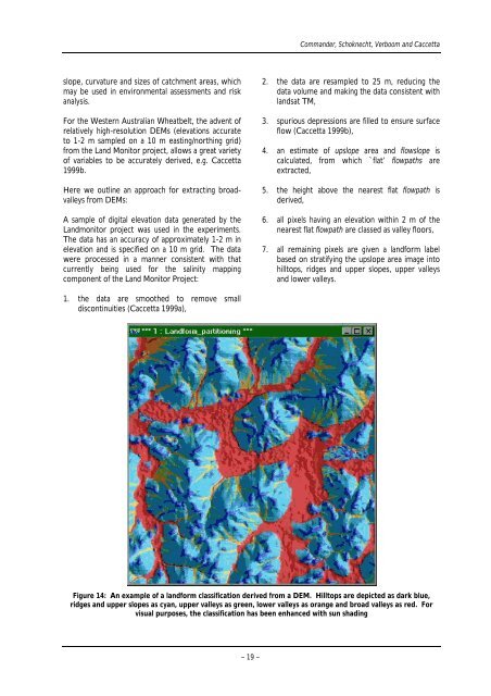
1. the data are smoothed to remove small<br />
discont<strong>in</strong>uities (Caccetta 1999a),<br />
Commander, Schoknecht, Verboom and Caccetta<br />
2. the data are resampled to 25 m, reduc<strong>in</strong>g the<br />
data volume and mak<strong>in</strong>g the data consistent <strong>with</strong><br />
landsat TM,<br />
3. spurious depressions are filled to ensure surface<br />
flow (Caccetta 1999b),<br />
4. an estimate <strong>of</strong> upslope area and flowslope is<br />
calculated, from which `flat’ flowpaths are<br />
extracted,<br />
5. the height above the nearest flat flowpath is<br />
derived,<br />
6. all pixels hav<strong>in</strong>g an elevation <strong>with</strong><strong>in</strong> 2 m <strong>of</strong> the<br />
nearest flat flowpath are classed as valley floors,<br />
7. all rema<strong>in</strong><strong>in</strong>g pixels are given a landform label<br />
based on stratify<strong>in</strong>g the upslope area image <strong>in</strong>to<br />
hilltops, ridges and upper slopes, upper valleys<br />
and lower valleys.<br />
Figure 14: An example <strong>of</strong> a landform classification derived from a DEM. Hilltops are depicted as dark blue,<br />
ridges and upper slopes as cyan, upper valleys as green, lower valleys as orange and broad valleys as red. For<br />
visual purposes, the classification has been enhanced <strong>with</strong> sun shad<strong>in</strong>g<br />
– 19 –


