

Dealing with salinity in Wheatbelt Valleys - Department of Water
Dealing with salinity in Wheatbelt Valleys - Department of Water
Dealing with salinity in Wheatbelt Valleys - Department of Water

You also want an ePaper? Increase the reach of your titles
YUMPU automatically turns print PDFs into web optimized ePapers that Google loves.
Hatton and Ruprecht<br />
water from one to another when and if they<br />
overflow. Grades along the Lockhart and P<strong>in</strong>grup<br />
rivers (the southern tributaries <strong>of</strong> Salt River) are very<br />
low (0.04 m/km and 0.24 m/km respectively), and<br />
from this Beard (1999) concluded that significant<br />
discharges are unlikely (however, see Flood<strong>in</strong>g<br />
section below).<br />
Unlike the valleys <strong>of</strong> most rivers, which usually<br />
broaden downstream, the valley <strong>of</strong> the Avon is wide<br />
near its source (77 km) and narrows to 5 km or less<br />
after Toodyay. These broad shallow valleys <strong>of</strong> the<br />
upper Avon are characteristic <strong>of</strong> the wheatbelt<br />
rivers.<br />
The flatness <strong>of</strong> the bulk <strong>of</strong> the wheatbelt river<br />
systems leads to historic, and amus<strong>in</strong>g, arguments<br />
regard<strong>in</strong>g catchment boundaries, the putative<br />
connections between systems, and even which way<br />
water flows. It is essential to appreciate that these<br />
river systems do not all flow as one l<strong>in</strong>ked system<br />
except <strong>in</strong> the most extreme events. In the<br />
Blackwood catchment, the Cobl<strong>in</strong><strong>in</strong>e River and<br />
Dongolock<strong>in</strong>g Creek are two headwater streams<br />
dra<strong>in</strong><strong>in</strong>g to Lake Dumbleyung. This section <strong>of</strong> the<br />
river has very low grades, approximately 0.17 m/km.<br />
The comb<strong>in</strong>ed dra<strong>in</strong>age enters Lake Dumbleyung,<br />
which is a permanent salt lake that is said to have<br />
been dry before land clear<strong>in</strong>g (Beard 1999). S<strong>in</strong>ce<br />
clear<strong>in</strong>g, Lake Dumbleyung is thought to have<br />
overflowed <strong>in</strong>to the Lower Blackwood only three<br />
times s<strong>in</strong>ce the 1870s. The cha<strong>in</strong>s <strong>of</strong> (mostly dry)<br />
lakes form a series <strong>of</strong> local storages that <strong>in</strong> most<br />
years are not overtopped by the surface flows from<br />
upstream.<br />
Commander et al. (2001, this proceed<strong>in</strong>gs) gives the<br />
geological history and background to the evolution <strong>of</strong><br />
the wheatbelt systems, and George & Coleman<br />
(2001, this proceed<strong>in</strong>gs) provides a description <strong>of</strong> the<br />
hydrogeology <strong>with</strong> special reference to regolith<br />
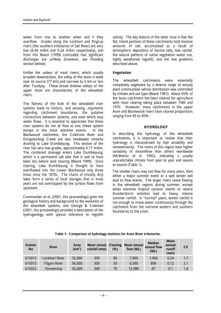
Station<br />
No<br />
River<br />
<strong>sal<strong>in</strong>ity</strong>. The key feature <strong>of</strong> the latter issue is that the<br />
flat, <strong>in</strong>land portions <strong>of</strong> these catchments hold massive<br />
amounts <strong>of</strong> salt, accumulated as a result <strong>of</strong><br />
atmospheric deposition <strong>of</strong> mar<strong>in</strong>e salts, low ra<strong>in</strong>fall,<br />
the natural patterns <strong>of</strong> native vegetation water use,<br />
highly weathered regolith, and the low gradients<br />
described above.<br />
Vegetation<br />
The wheatbelt catchments were essentially<br />
completely vegetated by a diverse range <strong>of</strong> woody<br />
plant communities whose distribution was controlled<br />
by climate and soil type (Beard 1981). About 65% <strong>of</strong><br />
the Avon catchment has been cleared for agriculture<br />
<strong>with</strong> most clear<strong>in</strong>g tak<strong>in</strong>g place between 1940 and<br />
1970. However, many catchments <strong>in</strong> the upper<br />
Avon and Blackwood rivers have cleared proportions<br />
rang<strong>in</strong>g from 85 to 95%.<br />
HYDROLOGY<br />
In describ<strong>in</strong>g the hydrology <strong>of</strong> the wheatbelt<br />
catchments, it is important to realise that their<br />
hydrology is characterised by high variability and<br />
nonstationarity. The rivers <strong>of</strong> this region have higher<br />
variability <strong>of</strong> streamflow than others worldwide<br />
(McMahon et al. 1992), <strong>in</strong>dicat<strong>in</strong>g a usually<br />
unpredictable climate from year to year and season<br />
to season (Table 1).<br />
The smaller rivers may not flow for many years, then<br />
either a major summer event or a wet w<strong>in</strong>ter will<br />
lead to flow events. The larger rivers cease flow<strong>in</strong>g<br />
<strong>in</strong> the wheatbelt regions dur<strong>in</strong>g summer, except<br />
when extreme tropical cyclonic events or severe<br />
thunderstorm activities lead to heavy, <strong>in</strong>tense<br />
summer ra<strong>in</strong>fall. In “normal” years, w<strong>in</strong>ter ra<strong>in</strong>fall is<br />
not enough to move water cont<strong>in</strong>uously through the<br />
catchment from the extreme eastern and southern<br />
boundaries to the coast.<br />
Table 1: Comparison <strong>of</strong> hydrology statistics for Avon River tributaries.<br />
Area<br />
(km 2 )<br />
Mean annual<br />
ra<strong>in</strong>fall (mm)<br />
Clear<strong>in</strong>g<br />
(%)<br />
Mean annual<br />
flow (ML)<br />
Median<br />
annual flow<br />
(ML)<br />
Mean<br />
annual<br />
run<strong>of</strong>f<br />
(mm)<br />
615012 Lockhart River 32,000 350 85 7,900 1,960 0.24 1.7<br />
615015 Yilgarn River 56,000 300 50 6,500 890 0.12 2.1<br />
615022 Yenyenn<strong>in</strong>g 92,000 340 70 12,980 87 0.1 1.4<br />
– 4 –<br />
CV


