

Dealing with salinity in Wheatbelt Valleys - Department of Water
Dealing with salinity in Wheatbelt Valleys - Department of Water
Dealing with salinity in Wheatbelt Valleys - Department of Water

You also want an ePaper? Increase the reach of your titles
YUMPU automatically turns print PDFs into web optimized ePapers that Google loves.
From the po<strong>in</strong>t <strong>of</strong> view <strong>of</strong> mapp<strong>in</strong>g and monitor<strong>in</strong>g<br />
<strong>sal<strong>in</strong>ity</strong>, the landform partition<strong>in</strong>g provides strong<br />
prior evidence <strong>of</strong> which parts <strong>of</strong> the terra<strong>in</strong> are likely<br />
to be/become sal<strong>in</strong>e (the red and orange areas) and<br />
which parts are not (the blue areas) (Caccetta 1997;<br />
Hojsgaard et al. 1997). Observations from satellite<br />
imagery provide further <strong>in</strong>formation on the status <strong>of</strong><br />
the land.<br />
An extension to the above idea is to predict which <strong>of</strong><br />
the valleys will experience high, sal<strong>in</strong>e water tables <strong>in</strong><br />
the future, which serves as a tool for land<br />
management and plann<strong>in</strong>g. This concept forms the<br />
basis for Land Monitor <strong>sal<strong>in</strong>ity</strong> prediction, a<br />
prelim<strong>in</strong>ary result which is shown <strong>in</strong> Figure 16. Here<br />
we note that the DEM provides some morphological<br />
<strong>in</strong>formation (<strong>in</strong> practice about a dozen morphological<br />
variables are derived (Caccetta 1999b), and<br />
geological <strong>in</strong>formation is required to place the<br />
morphological <strong>in</strong>formation <strong>in</strong> context. The third<br />
piece <strong>of</strong> <strong>in</strong>formation required is expert knowledge,<br />
provided by <strong>Department</strong> <strong>of</strong> Agriculture hydrologists<br />
Commander, Schoknecht, Verboom and Caccetta<br />
<strong>in</strong> this <strong>in</strong>stance, presented as samples <strong>of</strong> areas that<br />
are likely to (and not to) go sal<strong>in</strong>e <strong>in</strong> the future. This<br />
<strong>in</strong>formation is used to form a relationship between<br />
terra<strong>in</strong> and potential <strong>sal<strong>in</strong>ity</strong> for each significant<br />
geological region (e.g. Evans et al. 1995; Evans &<br />
Caccetta 2000).<br />
Giv<strong>in</strong>g Traditional Soil Mapp<strong>in</strong>g a New<br />
Perspective<br />
As an example we return to the prediction by Pa<strong>in</strong> &<br />
Ollier (1995) that rejuvenation exposes laterites that<br />
orig<strong>in</strong>ally formed on valley flank, and the prediction<br />
by Verboom & Galloway (2000) that lateritisation<br />
requires leach<strong>in</strong>g conditions and particular types <strong>of</strong><br />
vegetation. These compet<strong>in</strong>g ideas might be tested<br />
by exam<strong>in</strong><strong>in</strong>g the association between rejuvenation<br />
and soil distribution <strong>in</strong> valleys on the marg<strong>in</strong>s <strong>of</strong> the<br />
Yilgarn block. We consider the tectonically affected<br />
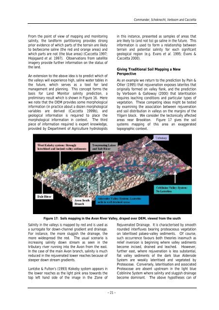
areas near Brookton. Figure 17 gives the soil<br />
systems mapp<strong>in</strong>g <strong>of</strong> this area an exaggerated<br />
topographic context.<br />
Figure 17: Soils mapp<strong>in</strong>g <strong>in</strong> the Avon River Valley, draped over DEM, viewed from the south<br />
Sal<strong>in</strong>ity <strong>in</strong> the valleys is mapped by red and is used as<br />
a surrogate for down-channel gradient and dra<strong>in</strong>age.<br />
For <strong>in</strong>stance, the more sluggish the dra<strong>in</strong>age, the<br />
more widespread the red. The usual scenario is<br />
<strong>in</strong>creas<strong>in</strong>g <strong>sal<strong>in</strong>ity</strong> down stream as seen <strong>in</strong> the<br />
tributary river runn<strong>in</strong>g <strong>in</strong>to the Avon from the east.<br />
In the case <strong>of</strong> the ma<strong>in</strong> Avon branch, <strong>sal<strong>in</strong>ity</strong> is much<br />
reduced <strong>in</strong> the rejuvenated lower reaches because <strong>of</strong><br />
steeper down stream gradients.<br />
Lantzke & Fulton’s (1993) Kokeby system appears <strong>in</strong><br />
the lower reaches as the light p<strong>in</strong>k area towards the<br />
top left hand side <strong>of</strong> the image <strong>in</strong> the Zone <strong>of</strong><br />
– 21 –<br />
Rejuvenated Dra<strong>in</strong>age. It is characterised by smooth<br />
rounded <strong>in</strong>terfluves bear<strong>in</strong>g proteaceous vegetation<br />
on lateritised palaeo-valley sediments. Of course,<br />
such occurrence favours both theories <strong>in</strong>asmuch as<br />
relief <strong>in</strong>version is beg<strong>in</strong>n<strong>in</strong>g where valley sediments<br />
become <strong>in</strong>cised, dra<strong>in</strong>ed and leached. However,<br />
further east, where rejuvenation is less substantial,<br />
flat valley sediments <strong>of</strong> the dark blue Alderside<br />
System are weakly lateritised and vegetated by<br />
Proteaceae. Conversely, lateritisation and associated<br />
Proteaceae are absent upstream <strong>in</strong> the light blue<br />
Cobl<strong>in</strong><strong>in</strong>e System where <strong>sal<strong>in</strong>ity</strong> and sluggish dra<strong>in</strong>age<br />
become dom<strong>in</strong>ant. The above hypotheses can <strong>of</strong>


