

Dealing with salinity in Wheatbelt Valleys - Department of Water
Dealing with salinity in Wheatbelt Valleys - Department of Water
Dealing with salinity in Wheatbelt Valleys - Department of Water

You also want an ePaper? Increase the reach of your titles
YUMPU automatically turns print PDFs into web optimized ePapers that Google loves.
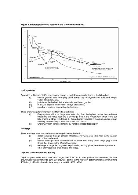
Figure 1. Hydrological cross-section <strong>of</strong> the Merred<strong>in</strong> catchment<br />
Hydrogeology<br />
Accord<strong>in</strong>g to George (1992), groundwater occurs <strong>in</strong> the follow<strong>in</strong>g aquifer types <strong>in</strong> the <strong>Wheatbelt</strong>:<br />
(i) coarse gra<strong>in</strong>ed soils overly<strong>in</strong>g pallid sandy clay (Collgar-duplex soils and Norpayellow<br />
sandpla<strong>in</strong> soils),<br />
(ii) just above the bedrock <strong>in</strong> the <strong>in</strong>tensely weathered granites,<br />
(iii) <strong>in</strong> alluvial deposits <strong>with</strong><strong>in</strong> major valleys (Belka unit),<br />
(iv) possibly <strong>in</strong> aquifers deep <strong>with</strong><strong>in</strong> the bedrock.<br />
There are two aquifer systems <strong>in</strong> the Merred<strong>in</strong> Catchment<br />
(i) Deep system <strong>with</strong> a recharge area extend<strong>in</strong>g from the highest part <strong>of</strong> the catchment<br />
through to the valley floor and a discharge area at the lowest po<strong>in</strong>t which is the salt<br />
lake cha<strong>in</strong>s at H<strong>in</strong>es Hill (Figure 4). Groundwater velocities <strong>in</strong> the deep aquifer system<br />
are very low (5cm/day <strong>in</strong> the mid to lower catchment).<br />
(ii) Shallow system controlled ma<strong>in</strong>ly by variation <strong>in</strong> local topography.<br />
Recharge<br />
There are three ma<strong>in</strong> mechanisms <strong>of</strong> recharge <strong>in</strong> Merred<strong>in</strong> district:<br />
(i) direct recharge through general <strong>in</strong>filtration over wide area (dom<strong>in</strong>ant <strong>in</strong> the eastern<br />
part <strong>of</strong> the catchment);<br />
(ii) <strong>in</strong>direct recharge from concentrations <strong>of</strong> creek flow along water ways (e.g. Cohns<br />
Creek that dra<strong>in</strong>s to the West <strong>of</strong> Merred<strong>in</strong>);<br />
(iii) recharge from garden irrigation, septic tanks, leak<strong>in</strong>g pipes, reticulation systems and<br />
other anthropogenic (man-made) <strong>in</strong>fluences.<br />
Depth to Groundwater and Sal<strong>in</strong>ity<br />
Depth to groundwater <strong>in</strong> the town area ranges from 2 to 7 m. In other parts <strong>of</strong> the catchment, depth <strong>of</strong><br />
groundwater varies from 0 to 35m. Groundwater <strong>sal<strong>in</strong>ity</strong> <strong>in</strong> the Merred<strong>in</strong> catchment ranges from 630 to<br />
43930 mg/L (Electrical conductivity ranges from 30 to 4700 mS/m).


