

Dealing with salinity in Wheatbelt Valleys - Department of Water
Dealing with salinity in Wheatbelt Valleys - Department of Water
Dealing with salinity in Wheatbelt Valleys - Department of Water

You also want an ePaper? Increase the reach of your titles
YUMPU automatically turns print PDFs into web optimized ePapers that Google loves.
Commander, Schoknecht, Verboom and Caccetta<br />
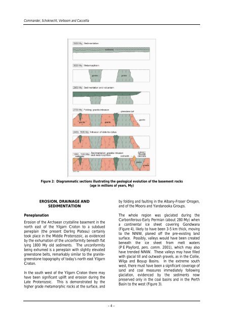
Figure 2: Diagrammatic sections illustrat<strong>in</strong>g the geological evolution <strong>of</strong> the basement rocks<br />
(age <strong>in</strong> millions <strong>of</strong> years, My)<br />
EROSION, DRAINAGE AND<br />
SEDIMENTATION<br />
Peneplanation<br />
Erosion <strong>of</strong> the Archaean crystall<strong>in</strong>e basement <strong>in</strong> the<br />
north east <strong>of</strong> the Yilgarn Craton to a subdued<br />
penepla<strong>in</strong> (the present Darl<strong>in</strong>g Plateau) certa<strong>in</strong>ly<br />
took place <strong>in</strong> the Middle Proterozoic, as evidenced<br />
by the exhumation <strong>of</strong> the unconformity beneath flat<br />
ly<strong>in</strong>g 1800 My old sediments. The unconformity<br />
be<strong>in</strong>g exhumed is a penepla<strong>in</strong> <strong>with</strong> slightly elevated<br />
greenstone belts, remarkably similar to the granitegreenstone<br />
topography <strong>of</strong> today’s north east Yilgarn<br />
Craton.<br />
In the south west <strong>of</strong> the Yilgarn Craton there may<br />
have been significant uplift and erosion dur<strong>in</strong>g the<br />
Late Proterozoic. This is demonstrated by the<br />
higher grade metamorphic rocks at the surface, and<br />
– 4 –<br />
by fold<strong>in</strong>g and fault<strong>in</strong>g <strong>in</strong> the Albany-Fraser Orogen,<br />
and <strong>of</strong> the Moora and Yandanooka Groups.<br />
The whole region was glaciated dur<strong>in</strong>g the<br />
Carboniferous-Early Permian (about 280 My) when<br />
a cont<strong>in</strong>ental ice sheet cover<strong>in</strong>g Gondwana<br />
(Figure 4), likely to have been 3-5 km thick, mov<strong>in</strong>g<br />
to the NNW, planed <strong>of</strong>f the pre-exist<strong>in</strong>g land<br />
surface. Possibly, valleys would have been created<br />
beneath the ice sheet from melt waters<br />
(P E Playford, pers. comm. 2001), which may also<br />
have trended NNW. These valleys may have filled<br />
<strong>with</strong> glacial till and outwash gravels, as <strong>in</strong> the Collie,<br />
Wilga and Boyup Bas<strong>in</strong>s. In the extreme south<br />
west, there must have been a significant coverage <strong>of</strong><br />
sand and coal measures immediately follow<strong>in</strong>g<br />
glaciation, evidenced by the sediments now<br />
preserved only <strong>in</strong> the coal bas<strong>in</strong>s and <strong>in</strong> the Perth<br />
Bas<strong>in</strong> to the west (Figure 3).


