

Dealing with salinity in Wheatbelt Valleys - Department of Water
Dealing with salinity in Wheatbelt Valleys - Department of Water
Dealing with salinity in Wheatbelt Valleys - Department of Water

Create successful ePaper yourself
Turn your PDF publications into a flip-book with our unique Google optimized e-Paper software.
– 11 –<br />
Hatton and Ruprecht<br />
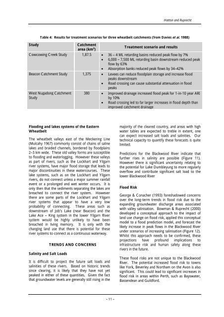
Table 4: Results for treatment scenarios for three wheatbelt catchments (from Davies et al. 1988)<br />
Study Catchment<br />
area (km 2 )<br />
Treatment scenario and results<br />
Cowcow<strong>in</strong>g Creek Study 1,87.5 • 36 – 4 ML retard<strong>in</strong>g bas<strong>in</strong>s reduced peak flow by 7%<br />
• 6,000 – 7,500 ML retard<strong>in</strong>g bas<strong>in</strong> downstream reduced peak<br />
flow by 63%<br />
• Absorption banks reduced peak flows by 34–42%<br />
Beacon Catchment Study 1,375 • Levees can reduce floodpla<strong>in</strong> storage and <strong>in</strong>crease flood<br />
peaks downstream<br />
• Road cross<strong>in</strong>g can cause substantial attenuation <strong>in</strong> flood<br />
peaks<br />
West Nugadong Catchment<br />
Study<br />
Flood<strong>in</strong>g and lakes systems <strong>of</strong> the Eastern<br />
<strong>Wheatbelt</strong><br />
The wheatbelt valleys east <strong>of</strong> the Mecker<strong>in</strong>g L<strong>in</strong>e<br />
(Mulcahy 1967) commonly consist <strong>of</strong> cha<strong>in</strong>s <strong>of</strong> sal<strong>in</strong>e<br />
lakes and braided channels, bordered by floodpla<strong>in</strong>s<br />
2–3 km wide. These old valley forms are susceptible<br />
to flood<strong>in</strong>g and waterlogg<strong>in</strong>g. However these valleys<br />
as part <strong>of</strong> rivers, such as the Lockhart and Yilgarn<br />
river systems, have major flood storage that leads to<br />
major discont<strong>in</strong>uities <strong>in</strong> these watercourses. These<br />
lake systems, such as on the Lockhart and Yilgarn<br />
rivers, do not connect unless a major summer ra<strong>in</strong>fall<br />
event or a prolonged and wet w<strong>in</strong>ter occurs. It is<br />
only then that the sediments separat<strong>in</strong>g the lakes are<br />
breached to connect the river system. However<br />
there are some parts <strong>of</strong> the Lockhart and Yilgarn<br />
river systems that appear to have a very low<br />
probability <strong>of</strong> connect<strong>in</strong>g. These areas such as<br />
downstream <strong>of</strong> Job’s Lake (near Beacon) and the<br />
Lake Ace – K<strong>in</strong>g system <strong>in</strong> the lower Yilgarn River<br />
system would be highly unlikely to have been<br />
breached <strong>in</strong> liv<strong>in</strong>g memory. It is only <strong>with</strong> the<br />
chang<strong>in</strong>g land use that there is potential for these<br />
river systems to connect as a cont<strong>in</strong>uous waterway.<br />
Sal<strong>in</strong>ity and Salt Loads<br />
TRENDS AND CONCERNS<br />
It is difficult to project the future salt loads and<br />
sal<strong>in</strong>ities <strong>of</strong> these rivers. Based on historic trends<br />
s<strong>in</strong>ce clear<strong>in</strong>g, it is likely that they have not yet<br />
peaked <strong>in</strong> either <strong>of</strong> these quantities. Given the fact<br />
that groundwater levels are generally still ris<strong>in</strong>g <strong>in</strong> the<br />
380 • Improved dra<strong>in</strong>age <strong>in</strong>creased flood peak for 1-<strong>in</strong>-10 year ARI<br />
by 10%<br />
• Road cross<strong>in</strong>g led to far larger <strong>in</strong>creases <strong>in</strong> flood depth than<br />
improved catchment dra<strong>in</strong>age<br />
majority <strong>of</strong> the cleared country, and areas <strong>with</strong> high<br />
water tables are expected to treble <strong>in</strong> extent, one<br />
can expect <strong>in</strong>creased salt loads and sal<strong>in</strong>ities. Our<br />
technical capacity to quantify these forecasts is quite<br />
limited.<br />
Predictions for the Blackwood River <strong>in</strong>dicate that<br />
further rises <strong>in</strong> <strong>sal<strong>in</strong>ity</strong> are possible (Figure 11).<br />
However there is significant uncerta<strong>in</strong>ty relat<strong>in</strong>g to<br />
the potential for Lake Dumbleyung to more regularly<br />
overflow and contribute significant salt load to the<br />
lower Blackwood River<br />
Flood Risk<br />
George & Conacher (1993) foreshadowed concerns<br />
over the long-term trends <strong>in</strong> flood risk due to the<br />
expand<strong>in</strong>g groundwater discharge areas associated<br />
<strong>with</strong> valley sal<strong>in</strong>isation. Bowman & Ruprecht (2000)<br />
developed a conceptual approach to the impact <strong>of</strong><br />
land use change on flood risk, applied this conceptual<br />
model to a flood prediction model, and forecast the<br />
likely <strong>in</strong>crease <strong>in</strong> peak flows <strong>in</strong> the Blackwood River<br />
under scenarios <strong>of</strong> <strong>in</strong>creas<strong>in</strong>g sal<strong>in</strong>isation (Figure 12).<br />
Whilst this approach needs to be confirmed, these<br />
projections have pr<strong>of</strong>ound implications to<br />
<strong>in</strong>frastructure risk and human safety along these<br />
rivers <strong>in</strong> the future.<br />
These flood risks are not unique to the Blackwood<br />
River. The potential <strong>in</strong>creased flood risk to towns<br />
like York, Beverley and Northam on the Avon is also<br />
significant. This could lead to significant <strong>in</strong>creases <strong>in</strong><br />
flood risk <strong>in</strong> areas <strong>with</strong><strong>in</strong> Perth, such as Bayswater,<br />
Bassendean and Guildford.


