

Dealing with salinity in Wheatbelt Valleys - Department of Water
Dealing with salinity in Wheatbelt Valleys - Department of Water
Dealing with salinity in Wheatbelt Valleys - Department of Water

Create successful ePaper yourself
Turn your PDF publications into a flip-book with our unique Google optimized e-Paper software.
Commander, Schoknecht, Verboom and Caccetta<br />
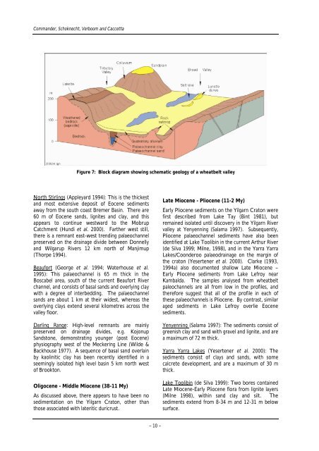
Figure 7: Block diagram show<strong>in</strong>g schematic geology <strong>of</strong> a wheatbelt valley<br />
North Stirl<strong>in</strong>gs (Appleyard 1994): This is the thickest<br />
and most extensive deposit <strong>of</strong> Eocene sediments<br />
away from the south coast Bremer Bas<strong>in</strong>. There are<br />
60 m <strong>of</strong> Eocene sands, lignites and clay, and this<br />
appears to cont<strong>in</strong>ue westward to the Mobrup<br />
Catchment (Hundi et al. 2000). Farther west still,<br />
there is a remnant east-west trend<strong>in</strong>g palaeochannel<br />
preserved on the dra<strong>in</strong>age divide between Donnelly<br />
and Wilgarup Rivers 12 km north <strong>of</strong> Manjimup<br />
(Thorpe 1994).<br />
Beaufort (George et al. 1994; <strong>Water</strong>house et al.<br />
1995): This palaeochannel is 65 m thick <strong>in</strong> the<br />
Boscabel area, south <strong>of</strong> the current Beaufort River<br />
channel, and consists <strong>of</strong> basal sands and overly<strong>in</strong>g clay<br />
<strong>with</strong> a degree <strong>of</strong> <strong>in</strong>terbedd<strong>in</strong>g. The palaeochannel<br />
sands are about 1 km at their widest, whereas the<br />
overly<strong>in</strong>g clays extend several kilometres across the<br />
valley floor.<br />
Darl<strong>in</strong>g Range: High-level remnants are ma<strong>in</strong>ly<br />
preserved on dra<strong>in</strong>age divides, e.g. Kojonup<br />
Sandstone, demonstrat<strong>in</strong>g younger (post Eocene)<br />
physiography west <strong>of</strong> the Mecker<strong>in</strong>g L<strong>in</strong>e (Wilde &<br />
Backhouse 1977). A sequence <strong>of</strong> basal sand overla<strong>in</strong><br />
by kaol<strong>in</strong>itic clay has been recently identified <strong>in</strong> a<br />
seem<strong>in</strong>gly isolated high level bas<strong>in</strong> 5 km north west<br />
<strong>of</strong> Brookton.<br />
Oligocene - Middle Miocene (38-11 My)<br />
As discussed above, there appears to have been no<br />
sedimentation on the Yilgarn Craton, other than<br />
those associated <strong>with</strong> lateritic duricrust.<br />
– 10 –<br />
Late Miocene - Pliocene (11-2 My)<br />
Early Pliocene sediments on the Yilgarn Craton were<br />
first described from Lake Tay (B<strong>in</strong>t 1981), but<br />
rema<strong>in</strong>ed isolated until discovery <strong>in</strong> the Yilgarn River<br />
valley at Yenyenn<strong>in</strong>g (Salama 1997). Subsequently,<br />
Pliocene palaeochannel sediments have also been<br />
identified at Lake Toolib<strong>in</strong> <strong>in</strong> the current Arthur River<br />
(de Silva 1999; Milne, 1998), and <strong>in</strong> the Yarra Yarra<br />
Lakes/Coonderoo palaeodra<strong>in</strong>age on the marg<strong>in</strong> <strong>of</strong><br />
the craton (Yesertener et al. 2000). Clarke (1993,<br />
1994a) also documented shallow Late Miocene –<br />
Early Pliocene sediments from Lake Lefroy near<br />
Kambalda. The samples analysed from wheatbelt<br />
paleochannels are all from low <strong>in</strong> the pr<strong>of</strong>iles, and<br />
therefore suggest that all <strong>of</strong> the pr<strong>of</strong>ile <strong>in</strong> each <strong>of</strong><br />
these palaeochannels is Pliocene. By contrast, similar<br />
aged sediments <strong>in</strong> Lake Lefroy overlie Eocene<br />
sediments.<br />
Yenyenn<strong>in</strong>g (Salama 1997): The sediments consist <strong>of</strong><br />
greenish clay and sand <strong>with</strong> gravel and lignite, and are<br />
a maximum <strong>of</strong> 72 m thick.<br />
Yarra Yarra Lakes (Yesertener et al. 2000): The<br />
sediments consist <strong>of</strong> clays and sands, <strong>with</strong> some<br />
calcrete development, and are a maximum <strong>of</strong> 30 m<br />
thick.<br />
Lake Toolib<strong>in</strong> (de Silva 1999): Two bores conta<strong>in</strong>ed<br />
Late Miocene-Early Pliocene flora from lignite layers<br />
(Milne 1998), <strong>with</strong><strong>in</strong> sand clay and silt. The<br />
sediments extend from 8-34 m and 12-31 m below<br />
surface.


