

Dealing with salinity in Wheatbelt Valleys - Department of Water
Dealing with salinity in Wheatbelt Valleys - Department of Water
Dealing with salinity in Wheatbelt Valleys - Department of Water

You also want an ePaper? Increase the reach of your titles
YUMPU automatically turns print PDFs into web optimized ePapers that Google loves.
Commander, Schoknecht, Verboom and Caccetta<br />
course be tested elsewhere but we leave that for<br />
now.<br />
AIRBORNE GAMMA-RAY SPECTROMETRY<br />
(RADIOMETRICS)<br />
This geophysical technique relies on an airborne<br />
<strong>in</strong>strument conta<strong>in</strong><strong>in</strong>g a thallium doped sodium<br />
iodide crystal. It measures the <strong>in</strong>tensity and energy<br />
<strong>of</strong> gamma radiation emitted from naturally occurr<strong>in</strong>g<br />
radioactive isotopes <strong>of</strong> potassium (K), Bismuth (Bi)<br />
and Thallium (Tl). Emission peaks from isotopes <strong>of</strong><br />
the last two elements are used to estimate the<br />
abundance <strong>of</strong> uranium (U) thorium (Th). N<strong>in</strong>ety<br />
percent <strong>of</strong> these emitted gamma-rays come from the<br />
top 30 - 45 cm <strong>of</strong> soil if it is dry and less than this if it<br />
is wet. An aircraft fly<strong>in</strong>g a series <strong>of</strong> transects at say<br />
100 m spac<strong>in</strong>gs can thus map the abundance <strong>of</strong> the<br />
above elements if the data that it collects is georeferenced.<br />
S<strong>in</strong>ce each element has its own peculiar<br />
soil chemistry and mobility, levels <strong>of</strong> radioactivity<br />
from each element, or comb<strong>in</strong>ation <strong>of</strong> elements<br />
betray soil properties and geomorphic processes.<br />
COMBINING DEM AND RADIOMETRIC<br />
DATA<br />
We have already seen that relationship between<br />
topography and soil depends, <strong>in</strong> large measure, on<br />
the way <strong>in</strong> which water <strong>in</strong>teracts <strong>with</strong> and moves<br />
over the surface and percolates downward. These<br />
<strong>in</strong>teractions determ<strong>in</strong>e the outcome <strong>of</strong> ra<strong>in</strong>wash and<br />
sub-aerial dissolution which <strong>of</strong> course depends on<br />
substrate and biological <strong>in</strong>fluences such as<br />
bioturbation, vegetative cover, exudates and bio-<br />
precipitates. Furthermore, soil landscape processes<br />
also reflect past macro and bioclimates. Not<br />
surpris<strong>in</strong>gly relationships between topography and<br />
soils are not always straight-forward but certa<strong>in</strong><br />
associations stand out when radiometric images are<br />
draped over the DEMs.<br />
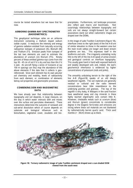
In the image <strong>of</strong> Lake Toolib<strong>in</strong> Catchment (Figure 18),<br />
<strong>in</strong>terfluve crests to the right (east) <strong>of</strong> the l<strong>in</strong>e A-B are<br />
<strong>of</strong> similar elevation to those <strong>in</strong> the western area but<br />
the ma<strong>in</strong> trunk valleys are longer and down stream<br />
gradients are less. This expresses itself <strong>in</strong> the<br />
landforms and soils. The irregularly undulat<strong>in</strong>g rocky<br />
hills to the left <strong>of</strong> the l<strong>in</strong>e A-B speak <strong>of</strong> active erosion<br />
and geological controls on <strong>in</strong>terfluve topography.<br />
This usually goes hand <strong>in</strong> hand <strong>with</strong> exposed bedrock<br />
and weakly developed soils and, <strong>in</strong>deed, the east’s<br />
geochemical <strong>in</strong>heritance is evidenced by higher<br />
concentrations <strong>of</strong> potassium (reds and p<strong>in</strong>ks).<br />
The smoothly undulat<strong>in</strong>g terra<strong>in</strong> to the right <strong>of</strong> the<br />
l<strong>in</strong>e A-B (Figure18) speaks <strong>of</strong> an old deeply<br />
weathered regolith. The soil materials are generally<br />
residual or colluvial and the radio element<br />
concentrations bear little resemblance to the<br />
underly<strong>in</strong>g granites and gneisses. The top <strong>of</strong> the<br />
regolith is very leaky, K feldspars <strong>in</strong> the sand fraction<br />
have weathered away and clay m<strong>in</strong>erals <strong>in</strong> these<br />
highly leached oligotrophic soils conta<strong>in</strong> little K.<br />
However, chelatable metals such as uranium (blue)<br />
and thorium (green) concentrate to considerable<br />
degree <strong>in</strong> the biogenic ferricretes and emissions are<br />
strong where these soil materials are not blanketed<br />
by radiometrically barren quartz sand. Thick sand<br />
mantles (> 30cm) shows up as black.<br />
Figure 18: Ternary radiometric image <strong>of</strong> Lake Toolib<strong>in</strong> catchment draped over a sun-shaded DEM<br />
viewed from the south west<br />
– 22 –


