

Dealing with salinity in Wheatbelt Valleys - Department of Water
Dealing with salinity in Wheatbelt Valleys - Department of Water
Dealing with salinity in Wheatbelt Valleys - Department of Water

You also want an ePaper? Increase the reach of your titles
YUMPU automatically turns print PDFs into web optimized ePapers that Google loves.
George and Coleman<br />
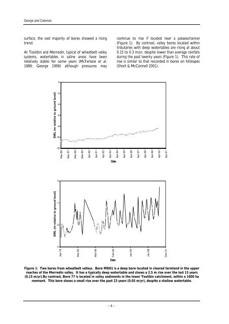
surface, the vast majority <strong>of</strong> bores showed a ris<strong>in</strong>g<br />
trend.<br />
At Toolib<strong>in</strong> and Merred<strong>in</strong>, typical <strong>of</strong> wheatbelt valley<br />
systems, watertables <strong>in</strong> sal<strong>in</strong>e areas have been<br />
relatively stable for some years (McFarlane et al.<br />
1989; George 1999) although pressures may<br />
SWL (m relative to ground level)<br />
SWL (m relative to ground level)<br />
0<br />
-2<br />
-4<br />
-6<br />
-8<br />
-10<br />
-12<br />
0<br />
-1<br />
-2<br />
-3<br />
Mar-86<br />
Apr-78<br />
Mar-87<br />
Mar-88<br />
Mar-82<br />
Mar-89<br />
Apr-90<br />
Apr-91<br />
Mar-86<br />
Apr-92<br />
Apr-93<br />
Date<br />
Feb-90<br />
Date<br />
cont<strong>in</strong>ue to rise if located near a palaeochannel<br />
(Figure 1). By contrast, valley bores located <strong>with</strong><strong>in</strong><br />
tributaries <strong>with</strong> deep watertables are ris<strong>in</strong>g at about<br />
0.15 to 0.3 m/yr, despite lower than average ra<strong>in</strong>falls<br />
dur<strong>in</strong>g the past twenty years (Figure 1). This rate <strong>of</strong><br />
rise is similar to that recorded <strong>in</strong> bores on hillslopes<br />
(Short & McConnell 2001).<br />
Figure 1: Two bores from wheatbelt valleys. Bore MD01 is a deep bore located <strong>in</strong> cleared farmland <strong>in</strong> the upper<br />
reaches <strong>of</strong> the Merred<strong>in</strong> valley. It has a typically deep watertable and shows a 2.5 m rise over the last 15 years<br />
(0.15 m/yr).By contrast, Bore 77 is located <strong>in</strong> valley sediments <strong>in</strong> the lower Toolib<strong>in</strong> catchment, <strong>with</strong><strong>in</strong> a 1000 ha<br />
remnant. This bore shows a small rise over the past 23 years (0.05 m/yr), despite a shallow watertable.<br />
– 4 –<br />
Apr-94<br />
Apr-95<br />
Apr-96<br />
Jan-94<br />
Apr-97<br />
Apr-98<br />
Jan-98<br />
Apr-99<br />
Apr-00<br />
Apr-01<br />
Dec-01


