1822 - Edocs
1822 - Edocs
1822 - Edocs
You also want an ePaper? Increase the reach of your titles
YUMPU automatically turns print PDFs into web optimized ePapers that Google loves.
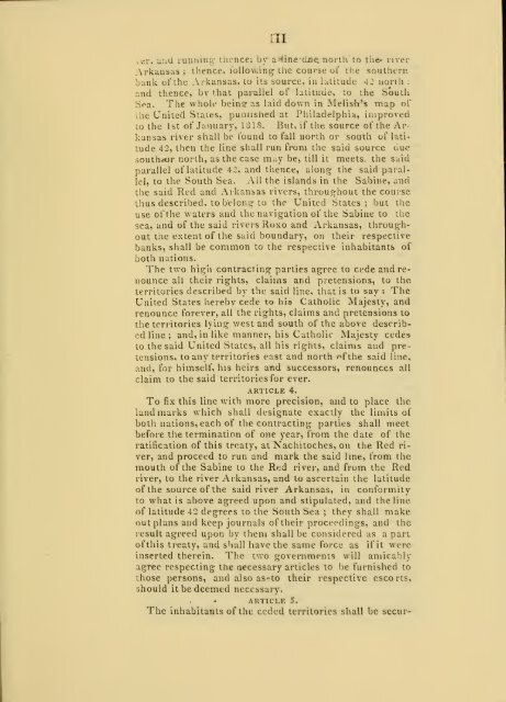
•II<br />
k-ePj unci running thence; by aHine-duanorth'to the- river<br />
Arkansas ; thence, following the course of the southern<br />
bank of the Arkansas, to its source, in latitude 42 uorth :<br />
and thence, by that parallel of latitude, to the South<br />
Sea. The whole being- as laid down in Melish's map of<br />
Jie United States, puoushed at Philadelphia, improved<br />
to the 1st of January, 1818. But, if the source of the Arkansas<br />
river shall be found to fall north or south of latitude<br />
42, then the line shall run from the said source due<br />
souttwor north, as the case m^y be, till it meets, the said<br />
parallel of latitude 42, and thence, along; the said parallel,<br />
to the South Sea. All the islands in the Sabine, and<br />
the said Red and Arkansas rivers, throughout the course<br />
thus described, to belong- to the United States; but the<br />
use of the waters and the navigation of the Sabine to the<br />
sea, and of the said rivers Roxo and Arkansas, throughout<br />
t:ie extent of the said boundary, on their respective<br />
banks, shall be common to the respective inhabitants of<br />
both nations.<br />
The two high contracting parties agree to cede and renounce<br />
all their rights, claims and pretensions, to the<br />
territories described by the said line, that is to say : The<br />
United States hereby cede to his Catholic Majesty, and<br />
renounce forever, all the rights, claims and pretensions to<br />
the territories lying west and south of the above described<br />
line ; and, in like manner, his Catholic Majesty cedes<br />
to the said United States, all his rights, claims and pretensions,<br />
to any territories east and north of the said line,<br />
and, for himself, his heirs and successors, renounces all<br />
claim to the said territories for ever.<br />
article 4.<br />
To fix this line with more precision, and to place the<br />
landmarks which shall designate exactly the limits of<br />
both nations, each of the contracting parties shall meet<br />
before the termination of one year, from the date of the<br />
ratification of this treaty, at Nachitoches, on the Red river,<br />
and proceed to run and mark the said line, from the<br />
mouth of the Sabine to the Red river, and from the Red<br />
river, to the river Arkansas, and to ascertain the latitude<br />
of the source of the said river Arkansas, in conformity<br />
to what is above agreed upon and stipulated, and the line<br />
of latitude 42 degrees to the South Sea ; they shall make<br />
out plans and keep journals of their proceedings, and the<br />
result agreed upon by them shall be considered as a part<br />
ofthis treaty, and shall have the same force as if it were<br />
inserted therein. The two governments will amicably<br />
agree respecting the necessary articles to be furnished to<br />
those persons, and also as-to their respective escorts,<br />
should it be deemed necessary.<br />
article 5.<br />
The inhabitants of the ceded territories shall be secur-


