
You also want an ePaper? Increase the reach of your titles
YUMPU automatically turns print PDFs into web optimized ePapers that Google loves.
ED [<strong>DCS</strong> USER MANUAL]<br />
NAME. For each waypoint you can assign a unique name. Type the name of the<br />
waypoint in this field and this name will then appear next to the waypoint on the map.<br />
TYPE. Each waypoint can be assigned a type of action that the aircraft will perform<br />
when it is at that waypoint. These include:<br />
<br />
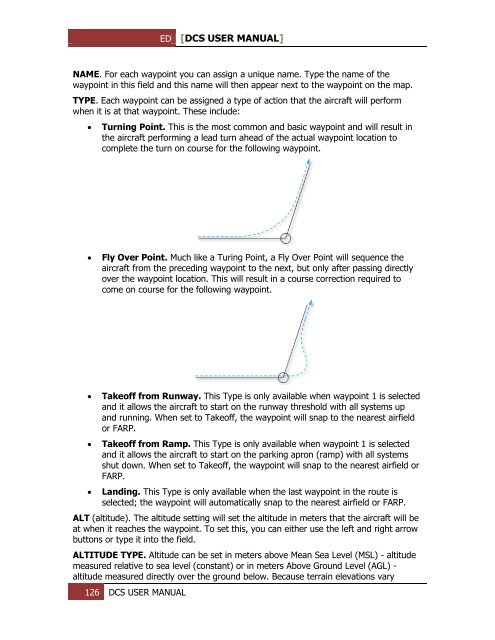
Turning Point. This is the most common and basic waypoint and will result in<br />
the aircraft performing a lead turn ahead of the actual waypoint location to<br />
complete the turn on course for the following waypoint.<br />
<br />
Fly Over Point. Much like a Turing Point, a Fly Over Point will sequence the<br />
aircraft from the preceding waypoint to the next, but only after passing directly<br />
over the waypoint location. This will result in a course correction required to<br />
come on course for the following waypoint.<br />
<br />
<br />
<br />
Takeoff from Runway. This Type is only available when waypoint 1 is selected<br />
and it allows the aircraft to start on the runway threshold with all systems up<br />
and running. When set to Takeoff, the waypoint will snap to the nearest airfield<br />
or FARP.<br />
Takeoff from Ramp. This Type is only available when waypoint 1 is selected<br />
and it allows the aircraft to start on the parking apron (ramp) with all systems<br />
shut down. When set to Takeoff, the waypoint will snap to the nearest airfield or<br />
FARP.<br />
Landing. This Type is only available when the last waypoint in the route is<br />
selected; the waypoint will automatically snap to the nearest airfield or FARP.<br />
ALT (altitude). The altitude setting will set the altitude in meters that the aircraft will be<br />
at when it reaches the waypoint. To set this, you can either use the left and right arrow<br />
buttons or type it into the field.<br />
ALTITUDE TYPE. Altitude can be set in meters above Mean Sea Level (MSL) - altitude<br />
measured relative to sea level (constant) or in meters Above Ground Level (AGL) -<br />
altitude measured directly over the ground below. Because terrain elevations vary<br />
126 <strong>DCS</strong> USER MANUAL