- Page 1 and 2:
Mangatawa Drain Flood Bypass and TE
- Page 3 and 4:
NZ Transport Agency and Tauranga Ci
- Page 5 and 6:
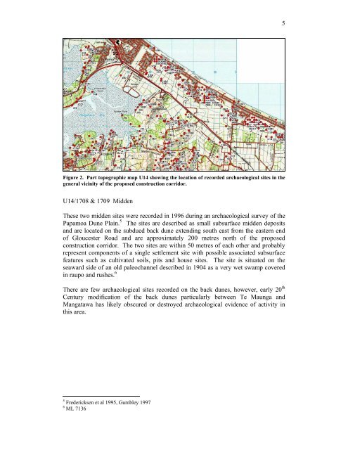
NZ Transport Agency and Tauranga Ci
- Page 7 and 8:
NZ Transport Agency and Tauranga Ci
- Page 9 and 10:
NZ Transport Agency and Tauranga Ci
- Page 11 and 12:
NZ Transport Agency and Tauranga Ci
- Page 13 and 14:
NZ Transport Agency and Tauranga Ci
- Page 16 and 17:
NZ Transport Agency and Tauranga Ci
- Page 18 and 19:
NZ Transport Agency and Tauranga Ci
- Page 20 and 21:
NZ Transport Agency and Tauranga Ci
- Page 22 and 23:
NZ Transport Agency and Tauranga Ci
- Page 24 and 25:
NZ Transport Agency and Tauranga Ci
- Page 26 and 27:
NZ Transport Agency and Tauranga Ci
- Page 28 and 29:
NZ Transport Agency and Tauranga Ci
- Page 30 and 31:
NZ Transport Agency and Tauranga Ci
- Page 32 and 33:
NZ Transport Agency and Tauranga Ci
- Page 34 and 35:
NZ Transport Agency and Tauranga Ci
- Page 36 and 37:
NZ Transport Agency and Tauranga Ci
- Page 38 and 39:
NZ Transport Agency and Tauranga Ci
- Page 40 and 41:
NZ Transport Agency and Tauranga Ci
- Page 43:
NZ Transport Agency and Tauranga Ci
- Page 46 and 47:
NZ Transport Agency and Tauranga Ci
- Page 48 and 49:
NZ Transport Agency and Tauranga Ci
- Page 50 and 51:
NZ Transport Agency and Tauranga Ci
- Page 52 and 53:
NZ Transport Agency and Tauranga Ci
- Page 54 and 55:
NZ Transport Agency and Tauranga Ci
- Page 56 and 57:
NZ Transport Agency and Tauranga Ci
- Page 58 and 59:
NZ Transport Agency and Tauranga Ci
- Page 60 and 61:
NZ Transport Agency and Tauranga Ci
- Page 62 and 63:
NZ Transport Agency and Tauranga Ci
- Page 64 and 65:
NZ Transport Agency and Tauranga Ci
- Page 66 and 67:
NZ Transport Agency and Tauranga Ci
- Page 68 and 69:
NZ Transport Agency and Tauranga Ci
- Page 70 and 71:
NZ Transport Agency and Tauranga Ci
- Page 72 and 73:
NZ Transport Agency and Tauranga Ci
- Page 74 and 75:
NZ Transport Agency and Tauranga Ci
- Page 76 and 77:
NZ Transport Agency and Tauranga Ci
- Page 78 and 79:
NZ Transport Agency and Tauranga Ci
- Page 80 and 81:
NZ Transport Agency and Tauranga Ci
- Page 82 and 83:
NZ Transport Agency and Tauranga Ci
- Page 84 and 85:
NZ Transport Agency and Tauranga Ci
- Page 86 and 87:
NZ Transport Agency and Tauranga Ci
- Page 88 and 89:
NZ Transport Agency and Tauranga Ci
- Page 90 and 91:
NZ Transport Agency and Tauranga Ci
- Page 92 and 93:
NZ Transport Agency and Tauranga Ci
- Page 94 and 95:
NZ Transport Agency and Tauranga Ci
- Page 96 and 97:
NZ Transport Agency and Tauranga Ci
- Page 98 and 99:
NZ Transport Agency and Tauranga Ci
- Page 100 and 101:
NZ Transport Agency and Tauranga Ci
- Page 102 and 103:
NZ Transport Agency and Tauranga Ci
- Page 104 and 105:
NZ Transport Agency and Tauranga Ci
- Page 106 and 107:
NZ Transport Agency and Tauranga Ci
- Page 108 and 109:
NZ Transport Agency and Tauranga Ci
- Page 110 and 111:
NZ Transport Agency and Tauranga Ci
- Page 112 and 113:
NZ Transport Agency and Tauranga Ci
- Page 114 and 115:
NZ Transport Agency and Tauranga Ci
- Page 116:
APPENDIX 1 - Drawing 3932036 ck301R
- Page 120:
APPENDIX 3 - Drawing 3932036 ck119
- Page 126:
APPENDIX 5 - Bioresearches Report:
- Page 205 and 206: APPENDIX 7 - Archaeological Assessm
- Page 207 and 208: ARCHAEOLOGY B.O.P. HERITAGE CONSULT
- Page 209 and 210: 2 INTRODUCTION Project Background T
- Page 211: 4 ARCHAEOLOGICAL LANDSCAPE Previous
- Page 215 and 216: 8 Figure 6. Part ML 8133 showing Pt
- Page 217 and 218: 10 Hungahunga & Toroa A further ton
- Page 219 and 220: 12 APRIL 2008 ARCHAEOLOGICAL SURVEY
- Page 221 and 222: 14 Historic Places Act In addition
- Page 223 and 224: APPENDIX 8 - Hydraulic Modelling: M
- Page 225 and 226: Hydraulic Modelling: Mangatawa Drai
- Page 227 and 228: undertake investigations into the d
- Page 229 and 230: Discharge to Papamoa Beach To disch
- Page 231 and 232: • Riparian planting adjacent to t
- Page 233 and 234: 2.2 Hydrological Assessment 2.2.1 C
- Page 235 and 236: The Maranui catchment area in the m
- Page 237 and 238: Table 7 - 2% AEP Storm Event Top Sp
- Page 239 and 240: These results include climate chang
- Page 241 and 242: 3.3 Maintenance Work in Mangatawa D
- Page 243 and 244: stormwater from the Maranui catchme
- Page 245: Appendix A Mangatawa Drain Layout P
- Page 249: Appendix C Runoff Hydrographs
- Page 255: Appendix E Proposed Lower Mangatawa
- Page 263:
APPENDIX 10 - Drawings 3932036 ck46
- Page 272:
APPENDIX 12 - Drawing 3932036 ck227
- Page 275 and 276:
Report Tauranga Eastern Motorway -
- Page 277 and 278:
1 Introduction This report describe
- Page 279 and 280:
embankment settlement rates, and th
- Page 281 and 282:
3.2 Construction Sequence The typic
- Page 283 and 284:
concrete contamination as well as s
- Page 285 and 286:
Pahse 1 consists of the western sec
- Page 287 and 288:
• Installation of Stage 2 decanti
- Page 289:
Appendix A Erosion and Sediment Con
- Page 295 and 296:
Activity Status Mangatawa Drain 1.1
- Page 297 and 298:
(b) Natural State (River) Water Qua
- Page 299 and 300:
6. Reclamation or drainage of the b
- Page 301 and 302:
APPENDIX 15 - Legal Descriptions of
- Page 303 and 304:
Path: P:\393\3932036\TGI\55_Project
- Page 311 and 312:
32 Harington Street PO Box 903, Tau
- Page 313:
32 Harington Street PO Box 903, Tau